Thursday, 25 October 2018

Skara Brae and Marwick Head

Saturday 1st September 2018

I didn't do my walks on Orkney with any logical progression as I went all over the place with little connection from day to day. At the start of this day I returned to the point where I had ended two days previously to continue along the trail beside the west coast of the Orkney mainland and reach the point where I had ended three days before. The principle motivator for doing this actual walk on this day was actually poor weather, so after enjoying several days of sunshine I was now greeted with low cloud for much of the day. Although it wasn’t raining it also wasn’t the weather to do anything particularly adventurous so I caught a bus to Skara Brae where there are the remains of a Neolithic village that was discovered amongst the dunes behind the Bay of Skaill. This was where I had ended my walk two days before, but I had not had the time then to look around, so now I devoted all of the morning to looking around the exhibition and at the reconstruction of what the Neolithic houses would have looked like when in use, before heading down to the shore to have a look around the actual uncovered village. It is an amazing place, although, it is so difficult to see how people lived in these tiny houses with their very low doorways I wondered if perhaps hobbits had lived in them!

Entry to Skara Brae also gives you entry into Skaill House, which is a large mansion house whose laird originally discovered the buried village. By the time I came out of Skaill House, Skara Brae was becoming excessively packed due to coachloads of tourists from the cruise ships that now flood Orkney every summer. Feeling that I had timed my visit just right I headed onto the beach of the Bay of Skaill and had my lunch while looking out over the mist-enshrouded bay. After eating I made my way north around the bay and joined the clearly marked path that continues the route along the rocky coastline. I couldn’t resist coming off the path several times to venture onto the wave washed rocks to get a closer look at the powerful seas that were pounding the coast. Despite the miserable weather I was fascinated by the craggy scenery and since I was in no hurry I slowly wandered beside the coast soaking in the landscape with no regard to the time. After my rushing about on the day before it was great to be able to take my time and not worry about making an appointment.

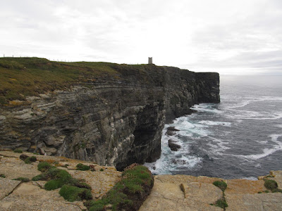
After passing a sea stack called the Spore and rounding Outshore Point I came down to some old fisherman’s huts hidden away in the picturesque inlet of Sand Geo. A short distance from there was the bay of Mar Wick with the hill of Marwick Head and its nature reserve ahead of me where many sea birds screamed over my head as I slowly climbed the hill beside increasingly tall cliffs. At the top of the hill was the impressive tower of the Kitchener Memorial that commemorates the death of Earl Kitchener whose ship, H.M.S. Hampshire, hit a mine on 5th June 1916 near this point. Although his name may not be known to everyone the minister of war is most famous these days as being the face and pointing finger on the “Your Country Needs You” posters. The cliffs below Marwick Head are amazing and once I had descended a short distance I was able to turn around and get a tremendous view of these amazing structures, standing above pounding waves and home to countless sea birds. The clouds above the tower were finally beginning to break with the sun attempting to come through and light up what had been a very grey and dull day.
With the tidal island of the Brough of Birsay before me I descended all the way down to the sea beside Birsay Bay and after crossing the grassy dunes I came into the village of Birsay where I had ended my walk three days before. The bus that I had taken back to Kirkwall on that day was not due for another two hours so I had a lot of time to kill. One option would have been to resume my progress along the St. Magnus Way that I had abandoned at the end of my walk three days earlier, but that trail keeps to roads for much of its traverse of Orkney, which is a little tedious. I did consider walking along the trail as far as the quaintly named Twatt crossroads, but in the end I decided to continue along the coast and return to the Brough of Birsay. From Marwick Head I could see that this tidal island was still cut off from the mainland, but by the time I reached the Point of Buckquoy the tide had sufficiently receded to enable me to make a dry footed crossing onto the island where I could, once again, have a look around the remains of the medieval monastery and Viking settlement.

It is astonishing to consider the time difference between this village and the one at Skara Brae with the latter being five thousand years old while the one on Birsay is just one thousand years old. Ultimately when all you have left is a rectangle of stones on the ground there is not much difference between the two despite supposedly four thousand years of progress, especially after one thousand years of wear has wiped it all away. Even though I had looked around the site just three days ago I still spent a long time walking around again, possibly seeing more than I had seen the first time. I also walked up to the lighthouse again that is at the highest point on the island, taking a different route to the one I had taken before until finally I returned across the causeway to the village of Birsay where I caught the bus back to Kirkwall. By the end of the day the sun had come out and it was just as sunny as it had been on my previous days on Orkney, but this was too late for me to take advantage of it. Despite the poor weather I had an enjoyable day looking around the fascinating Skara Brae before having a good walk along the coast taking my time and enjoying the walk past stunning scenery. The secret to happiness is to take your time.

Thursday, 18 October 2018

Ward Hill and the Ring of Brodgar

Friday 31st August 2018

On planning my holiday in the Orkney Isles I had decided upon the walks that I wanted to do and rather arbitrarily, as I thought of them, assigned a day to them. In the event I have not kept to that original schedule with a lot of changes taken simply to suit my whim at the time. I was going to do a completely different walk on this day until late the previous evening I decided to this walk in order to take advantage of a guided tour around the Ring of Brodgar. First, however, I caught a bus to Orphir where I  headed along a quiet road south until I reached the shore overlooking the vast Scapa Flow, which is the body of water that is sheltered by the encircling islands of Orkney to create one of the great natural harbours of the world, and during the two world wars was the home base for the Royal Navy. There is a fantastic little walk that follows the coast and gave me stunning views across Scarpa Flow with the hills of Hoy on the horizon under spectacular, clear blue skies with a splendid display of wild flowers lining the shore at my feet, but the strong Orkney wind was particularly vicious as I made my way along the shoreline path. Heartbreakingly, this wonderful coastal walk is woefully too short and soon came to an end in Orphir Bay where I turned inland passing through a churchyard.

At this point is the remains of the medieval round church of St Nicholas, the low foundations of the 12th Century manor house, Earl’s Bu, thought to be the one mentioned in Viking sagas, and finally an exhibition in the Orkneyinga Saga Centre, which shows the rich Viking heritage of the area. I didn’t spend much time there being more interested in the coastal walk so I headed back along the road to Orphir, and on the outskirts of the village I turned onto a farmer’s lane and climbed up towards the hill that dominates the view. After a while I realised this lane was a dead end and when I check my map I realised I had turned up the wrong lane, so I had to turn around, return to the main road, find the correct one and climb that. This lane brought me onto the open moorland passing a military firing range (that wasn’t in use) on a track that took me up the hill to the col between Gruf Hill and Ward Hill. At that point the view west towards Stromness opened out before me in spectacular array, but I was not heading that direction. Turning right I followed narrow trails in the heather to climb all the way up to the trig point at the summit of Ward Hill.

I had extensive views across the mainland of Orkney from the top, but there was also clearly a higher point further north so after crossing the saddle I eventually reached the highest point on the mainland. The Ordnance Survey gives this top the rather dull name of Mid Hill, but surely that just means it is the middle top of Ward Hill, and that name covers the whole sprawling upland mass? My eyes were drawn to the view down into the bowl below centred on the Lochs of Stenness and Harray, and especially to the Ness of Brodgar, the narrow strip of land between the two lochs where so much Neolithic excavation has recently been carried out. That was my destination, but first I had to get down off the hills as quickly as possible with no path and through thick heather until eventually I reached an old quarry track in Russa Dale. This was a gorgeous path, richly lined by heavily overgrown plants that was a joy to walk along, and I only wish I hadn’t been in such a hurry so I could have enjoyed this gloriously wild landscape. Instead I hurried down the path and along the road to reach the tour that started at one o’clock quick marching for three miles passing the Stones of Stenness and the vast archaeological dig at the Ness of Brodgar on the way, until eventually I reached the Ring of Brodgar ten minutes late for the tour.

Fortunately I had not missed much of the tour so I was able to join the crowd as the guide described the local flora before heading up to the Ring of Brodgar, a wide circle of standing stones that could be as much as five thousand years old, predating both Stonehenge and the Pyramids of Egypt. After the excellent tour I quickly headed back along the road to keep another date two miles away in the village of Stenness where a guided tour departs for the mysterious chambered cairn of Maes Howe. Access is by pre-booked guided tour only, and I was on the three o’clock tour of the astonishingly well-preserved chamber that is an amazing place to visit with a spooky, otherworldly feel that possibly explains why there are so many extensive Neolithic remains in the area. After returning to Stenness I was now free to wander back to the Stones of Stenness that I had rushed past earlier, but I was now able to explore these enormous standing stones that are far taller than any in the Ring of Brodgar. As the shadows lengthened I returned to the Ring of Brodgar for another visit until finally I made my way once more past the Stones of Stenness and back to the village of Stenness where I caught a bus back to Kirkwall.

While rushing around these Neolithic sites all afternoon the weather was amazing, despite strong winds, with bright sunshine and blue skies that created a perfect backdrop for these awesome standing stones. No one really knows what these Neolithic monuments were built for, or even what purpose the chambered cairn of Maes Howe served though historians will always speculate, but they must have had very special significance for the people who built them to have gone to the enormous effort required. I felt fortunate to see these amazing artefacts, and be able to enjoy them in such good weather.  Orkney is a fabulous place with coastal paths alongside a natural harbour steeped in history, to moorland hills with extensive views and ancient monuments that intrigue with the mysteries of their purpose and setting.

Friday, 12 October 2018

Black Craig and the Yesnasby cliffs

Thursday 30th August 2018

It started raining as soon as I left the Kirkwall Youth Hostel at the start of this day, so by the time I reached the bus station the short, heavy shower had left me quite wet, but fortunately the rain was short-lived and the weather gradually improved throughout the rest of the day providing me with an amazing afternoon of walking along some truly sensational coastal terrain. The bus took me to Stromness, the second largest town on Orkney and the main ferry terminal from the Scottish mainland, but I wasn’t taking the ferry anywhere. Instead I walked through the narrow streets out to the point of Ness where I had views across the Sound of Hoy to the island of Hoy where the biggest hills in all of Orkney beckoned me over and teased me for not making the crossing. Instead I continued along the coast passing some World War Two gun emplacements, Links Battery, while further along the coast and up the hill was a much larger and better preserved complex of gun emplacements and barracks, Ness Battery. Unfortunately access is only available as part of a guided tour and the tour for that day was at four o’clock. If I’d known this in advance I could have done the walk in the opposite direction and ended at Ness Battery, but instead I continued along the coast while the morning cloud-cover slowly began to clear.

The path slowly deteriorated as I passed Warebeth beach until eventually I reached a sign declaring that the coastal path to Skara Brae headed inland at this point. I had wanted to keep to the coast so was rather annoyed, but since there was barley in the next field I felt I couldn’t proceed further, though I suppose I could have tried walking along the stony beach. However, I didn’t consider this option at the time, so I turned inland heading up the hill until I reached a farmer’s track where I could see no indication whether I should turn left or right. In order to keep following the coast I turned left and soon came into a grassy field, but rather than turning around I crossed to the far corner of the field, climbed over a wire fence and kept going like that until eventually I dropped back down onto the beach. When I ran out of beach I had to continue trying to cross various barbed wire and electrified fences, until eventually, after a lot of difficulty, I reached some very modern looking buildings that is the wave test site for the European Marine Energy Centre. From there a faint path between the fields and the shore provided me with a more reliable route towards the imposing cliffs of Black Craig.

As the terrain steepened I decided to branch away from the clifftop path in order to reach the structure that sits at the top of Black Craig, which I found to be an old lookout station now used by EMEC for their wave energy research. There I sheltered from the ever-present Orkney wind and had my lunch before setting off along a now clear path onto open moorland north. Since I was now restored to the correct route along the coast after my earlier transgressions I now made rapid progress and after one last, brief, shower the skies cleared so I was now able to enjoy lovely sunshine under bright blue skies beside increasingly dramatic coastal scenery. After passing the spectacular sea stack of the Castle of North Gaulton, the terrain became exceptional with awesome cliffs below a craggy shoreline washed clear of soil by the tremendous power of the waves surmounting the cliffs. The coastline near Yesnasby is utterly awe-inspiring and I had great weather in which to enjoy it as I hopped from rock to rock keeping to the edge of the complex coastline while passing the two-legged sea stack of Yesnasby Castle.

I couldn’t believe how awesome this landscape was that reminded me of being at the top of a high mountain in the Lake District, such was the abundance of rock. After exploring the Point of Qui Ayre, within sight of the Castle, I made my way along the coast and up to the cairn at the top of the Brough of Bigging before coming back down and around the stunning inlet of the Noust of Bigging. I was having so much fun I didn’t want this to end, but the sensational terrain could not last forever as further north the coast deteriorated from the excellence of Yesnasby. Although the terrain was now less dramatic I still had a lot of bare rock to enjoy walking on as I continued along the coast passing the ruins of the Broch of Borwick and the deep inlet of Ramna Geo while slowly making my way up the coast to Ward Hill. After passing the natural arch of Hole O’ Row, I slowly descended into the Bay of Skaill where I explored the rocky shoreline before finally reaching the sandy beach not far from the remains of the Neolithic village of Skara Brae.

I didn’t have time to visit the village so I slowly wandered along the beach for a time enjoying the sunshine before heading back to the visitor centre at Skara Brae where I caught the bus back to Kirkwall. This was a stunning walk that was almost ruined by going the wrong way across the fields just outside Stromness, but once I reached the top of Black Craig the walk quickly improved with the weather until I reached the truly stunning coastal scenery of Yesnasby in the warm, afternoon sunshine. I thoroughly enjoyed myself there and it was one of those moments that you wish could never end. With hindsight I wish I’d stayed at Yesnasby, spending more time exploring the fabulous coastline, but life moves on and I also moved on along the coast, so I just have accept that. You can’t stay in one place, you have to move on.

Friday, 5 October 2018

The Broch of Gurness and the Brough of Birsay

Wednesday 29th August 2018

When I arrived in the Orkney Isles it was rather late in the evening, so the following morning I was still settling in, getting myself organised, and that dictated the walk I did on this day. Therefore I found myself catching the later 9.37 bus rather than the earlier 9.15 buses to elsewhere on the island. This bus dropped me off in the scattered community of Evie on the north coast of the mainland of Orkney where I set off along a quiet road with good views out to the coast with the island of Rousay beyond. Despite strong, cold winds the weather was good with lovely sunshine as I walked past Aikerness Farm and along a track to the top of a low hill on Aiker Ness. On the far side of the hill I could see the remains of the Broch of Gurness to my left and a clear view across Eynhallow Sound to Rousay. I came down the hill and turned left when I reached the coast making my way through rough vegetation to the wall that surrounds the site of the Broch of Gurness, easily crossing the wall on a stile to gain entry to the Iron Age ruins of a broch, a building style that is unique to Scotland.

After a good look around the site I went to the entrance where I found that I was supposed to have paid to enter, which I hadn’t done by walking across the fields to the back of the site. I had had a similar experience when I was in Orkney eighteen years earlier and didn't discover that I was supposed to have paid until after looking around the Earl’s Palace in Kirkwall. To prevent any further such problems on this holiday I promptly paid not only for entry to this site but to all Historic Scotland sites on Orkney by purchasing an Orkney Explorer Pass. Having now paid for entry I felt compelled to look around the Broch of Gurness again before finally leaving and heading west along the coast soon reaching the beautiful Sands of Evie. I had a lovely walk beside the sea along the beach in the bright sunshine with no haste while slowly enjoying every step. Eventually I ran out of beach and came up to a small car park where on a signpost I found a tiny symbol of a cross with a wavy line underneath, which marks the route of the St Magnus Way. This is a newly introduced long distance trail across the mainland of Orkney that starts in Evie going all the way to Kirkwall, but I had no intention of following the whole route, however the first stage served my purpose along the coast so would be my route for the day.

After resuming my walk along the beach for a while I climbed back up onto the edge of fields following a fence. The St Magnus Way website describes this as being some of the roughest walking on the entire route and eventually I came to a point where it looked like I could proceed no further even though the official route does continue along the coast for some way beyond. A barbed wire fence was blocking my route so I made my way inland through several fields until I eventually reached the road, which I followed passing after a while the path that comes up from the shore, but I don’t know how I could have reached that point. While continuing along the road for what seemed like ages a heavy rain shower fell that drenched me despite being short-lived so that by the time I reached the point where the trail returns to the shore I was soaked. Once back at the coast I stopped to eat my lunch and dry off while enjoying the stunning scenery, and under clear blue skies I soon dried off. When I resumed my trek along the rocky shore I had a truly satisfying time while hopping from rock to rock along the shoreline.

Eventually I came to a point where I could no longer keep to the shore and I had to climb up to the field edges where a narrow path followed the cliff-edge above a steep drop to the sea far below until I finally reached the point where the St Magnus Way turns inland once again to climb back up to the road. A short walk along this road brought me to a track that climbs up to the trig point at the top of Costa Hill where there are also some concrete ruins that are probably the Ernie Tower as marked on the O.S. map, though what they are seems to be vague with an internet search suggesting they had been radio station and/or an early wind turbine. From this point the St Magnus Way is marked by low wooden posts adorned with the familiar symbol and I was reminded of the way the Hebridean Way is signposted across the pathless moorland of the Outer Hebrides, though once these had brought me down from the top of Costa Hill to the coast they seemed to abandon me. So, rather than staying in the direction the posts had been leading me I turned left and followed the cliff-edge continuing to descend the slopes of Costa Hill to the sea inlet of Ramma Geo. Not far from there is a sea stack called Standard Rock, which some people have been known to climb, but I had difficulty in just viewing it from the top of the tall, steep cliffs due to the strong winds.

Continuing along the now well-marked St Magnus Way, I was making good progress in the gorgeous weather along the top of the cliffs beside a stunning coastline with the tidal island of the Brough of Birsay now clearly in view. The deep inlet of Whitaloo Point required some tricky and steep walking and after more satisfying walking around Skipi Geo I finally reached the Point of Buckquoy with the Brough of Birsay before me. Fortunately the tide was out and I was able to walk across the causeway to reach the remains of a medieval monastery and a Viking settlement. There is an entry fee to this site but since it was late in the afternoon the nearby building was not open to take your money. I’m sure if the tide had been out in the middle of the day then the site would have been manned but since high tide was six o’clock there was no one there, despite loads of people looking around the ruins, however my entry fee was covered by the Explorer ticket. After a look around I headed up to the lighthouse at the highest point on the island and then I followed the coast around to return to the ruins and finally back across to the mainland. Since I had a bit of time left until my bus was due I took a look around the sixteenth century Earl’s Palace in Birsay, though it wasn’t particularly interesting. However, this walk was fantastic with the sunshine helping, but the scenery along the coast was amazing and made me eager for more days in Orkney.