Tuesday, 3 September 2019

Friston Forest, The Seven Sisters and Cuckmere Haven

Cuckmere Meanders
This is one of the classic walks in Sussex and it would have been seriously remiss of us not to do it while staying in the Cuckmere Valley.  It is a walk that has pretty much everything - beautiful forest, dramatic cliffs, an unspoiled river valley and a rustic village.  It is another of those parts of Sussex of which I am particularly fond.  This walk can be found in volume 67 of the Pathfinder Guides East Sussex and The South Downs.  Doing this walk during the summer months is probably best done early morning or in the evening because parking at the Seven Sisters Country Park can be at a premium on a weekend day.  We were fortunate enough to be able to avoid the weekend and go quite early in the morning.

West Dean Church
From the car park we crossed the busy A259 - this has become monstrously busy and it isn't easy finding the best spot to cross.  It doesn't really matter whether you decide to park by the river or in the forest either as they both entail crossing this road.  Possibly easier first though as we found for the traffic was lighter early in the morning.  We walked up the small grassy slope to the gap in the wall at the top.  It certainly pays to look back at this point as the view towards the sea is one of the classic Sussex views.  The meander loops that are very evident in the valley are unnatural ox-bow lakes that were by-passed when a cut through was made.  I'm still not clear why this was done for the river is almost unnavigable along its entire length by all but the smallest of vessels.  When you see the oxbow lakes up close you realise how shallow they are in the absence of water feeding them from upstream.  There have been various proposals to re-instate the meander loops but they have so far come to nothing and as a result the landscape still looks pretty much the same as it has in my whole life.

Colourful Field
Once in the forest the surroundings could not be more different.  Almost instantly we lost the relatively modest height we had gained, this time down some steep steps into the small village of West Dean.  This little place has always exuded money but having not been here for a few years it somehow seemed more opulent than I ever remember.  I wonder how it would have looked one hundred years ago before the forest came into existence or it became so accessible by car?  I'll wager it was a forgotten backwater with most of the residents on very low disposable incomes.  The character of the village must have changed considerably when the forest was established in the 1950s.  I can remember as a child that most of the trees surrounding the village were once conifers but they have gradually been replaced by beech trees and it looks like a much more natural woodland these days as a result.

Friston Church
The church in West Dean is of particular note as it is Saxon in origin and as such is by far the oldest in the Cuckmere valley.  It is certainly worth taking a short detour off the advertised path to take a closer look.  It is surrounded by some flint buildings of genuine antiquity but showing signs of gentrification and renovation in recent years - the new looking mortar is a giveaway and they certainly cannot be described as rustic any longer.  Having taken a deserved look at the church we continued up the hill noting that cars seemed to be allowed up here but only if you had a key to the gate.  It seemed a little strange until we realised that not much further on were some cottages deep in the forest that probably once stood in open downland.  I'm not entirely sure I would like to live in such a location - it must be quite scary being surrounded by so many trees on a wild blustery night when the trees wave about and limbs break off.

Friston Pond
We kept right at the next path junction and walked a fairly lengthy section through the trees, dropping down into a valley and continuing straight on up the hill on the other side until we reached an area that we always referred to as The Gallops when I was a child.  I imagine that race horses must have trained here once upon a time.  I'm not sure if that is still true but what is undeniable is that seeing such an expanse of grassland after so much forest is quite surprising.  We skirted along one side of it and dropped down into the next dry valley where we had to take a dog-leg detour around Friston Place.  This 16th Century house was once owned by Sir Hartley Shawcross, Attorney General in the Attlee Government shortly after World War II.  He was the British representative in the Nuremburg Trials.  There are some nice glimpses of the house as you go around the perimeter wall - apparently the gardens open occasionally for charity if you want a closer look.

Departing Ferry
We climbed up and away from the house, crossing some pastures as we did so.  We came upon a sheep trapped in a thorny branch and once we had done so the hapless creature ran away at a rate of knots.  I caught sight of a beautiful field beyond, full of poppies and various yellow flowers and especially ragwort.  Perhaps they could have been considered weeds to anyone wanting to use the field for grazing but they did make for a colourful sight.  Sadly I couldn't get a very close look for it was beyond the private drive to Friston Place and I had to make do with my distant view.

Crowlink Cottages
We climbed up to the tiny village of Friston with its squat church and small pond at the heart.  Sadly the church is anything but peaceful these days as it is passed by the busy A259.  We crossed the road and I took a closer look at the pond which appears to have been taken over by a conservation group.  There is an observation platform and some interpretation boards and it looks like a habitat that is full of life.  Beyond the church and the landscape changed once again as we entered the Crowlink estate.  The forest was replaced by open downland full of grazing sheep.  Beyond them and we could see the Newhaven to Dieppe ferry leaving for the morning sailing.  It was a journey that we would be making ourselves not long after completing this walk.

View Across Seven Sisters
The path continues down through the beautiful Crowlink Estate all the way down to the cliff edge of a valley between two of the Seven Sisters.  Long time readers of this blog may well remember me coming this way on previous walks, notably when I completed the South Downs Way and then later the Sussex Coastal Walk.  For the first time though I would be walking in the opposite direction, so that the highest of the Sisters, Haven Brow, would be last.  We actually climbed Brass Point first and then in turn we went across Rough Brow, Short Brow and then Haven Brow.  

Closer Look
The views along the Seven Sisters are quite magnificent, for my money they are the finest chalk cliffs  in existence bar none and are far nicer than the more celebrated White Cliffs of Dover.  They appear to have caught the attention of Japanese and Chinese tourists and we passed several groups of them as we walked westwards.  They appear to have far too little fear of the height of the cliffs as many of them got far too close to the edge - we hollered at one group who were practically on the edge looking down.  They clearly have no understanding of how crumbly these cliffs are - we had visions of We lingered at the top of Haven Brow for some time admiring the view across the Cuckmere Estuary - it's rare I get to see it from this angle more's the pity as it is just as magnificent from this side as it is from the other side.

Cuckmere Estuary
The path doesn't go straight down the side of Haven Brow to the beach  below much to our relief.  A path as steep as that is a little hard on the knees.  Instead we headed inland on a much more gentle path that dropped down to the side of the river valley much more slowly.  It's a path that allows for the view to be extended for a much longer time and is definitely easier to negotiate!  At the bottom of the hill we joined the concrete road that once was the course of a tramway that took gravel from the beach to a station where the car park is that we used.  The line was open from 1930 to 1964.  The concrete road is a useful way for cyclists and all manner of non-powered transport to get to the beach, ideal for disabled people and people with pushchairs.  We didn't follow the road all the way back - at Foxhole the path takes the line of the South Downs Way up and over the small ridge to the right hand side.  We got a good view of the wildlife in the ox-bow lakes and especially a number of egrets that were busy fishing.  I wasn't sure that fish lived in this brackish water but I guess there must be plenty judging by the number of fishing birds.

Egret
As we returned to the car park there were plenty of visitors heading out for the day.  We felt a little smug knowing that we had already had the best of the weather and the countryside mostly to ourselves.  This is a fantastic walk and it is hard to believe that it packs in so much to its relatively modest 6 mile length.  I cannot recommend it highly enough if you find yourself in East Sussex.
Picnic at Exceat Barn

Wednesday, 28 August 2019

Arlington and Abbotts Wood

Puffy Clouds
After all the tropical posts I imagine that a few followers will be surprised to see a blog entry from the UK once again but we headed back for a lengthy summer trip after our first year at our new school.  As you can imagine we were very keen to do a few walks while we were back and used our base in Alfriston to explore a few places in East Sussex between family and friends visits.  This particular walk linked together a couple of old haunts and is walk number 23 from Pathfinder Guide 67 East Sussex and the South Downs.


Ripening
Arlington Reservoir used to be a popular winter walk for us as it is relatively short and suited the legs of small children but also it was relatively clean throughout the perimeter path even in the depths of winter when other places are afflicted by mud.  A trick we learned from our many visits is to park in the layby outside the reservoir  and not the official car park.  There are usually plenty of spaces and you will save yourself the parking fee (useful for refreshment money later!).  Upon entering the reservoir area we took a left turn and initially headed along the shore of the artificial lake that was created in 1971 to provide drinking water for Eastbourne.  Nearly 50 years on from its creation it now seems at home in its surroundings and the edges have softened sufficiently to look like it might be natural.  The view across the reservoir is great with Windover Hill and the chalk figure of the Long Man  of Wilmington as the backdrop.
Visitor
Our loop of the reservoir this time didn't last long as the path soon led off to our left and across fields with ripening wheat and almost ripe barley.  There was a slight breeze that helped the individual stalks wave almost mesmerically and for a few brief moments I was transfixed by the movement.  All in the hedgerow alongside were dozens of bees going about their business and quite a few butterflies.  It was pleasing to see the butterflies as we had heard that numbers seemed to have been decreasing in recent years.  We noticed a lot of painted ladies in particular - apparently it was a year where their numbers had swelled.

Barley
The path led us across fields to Upper Dicker passing by an old moat apparently.  I did look for it without success as it was buried somewhere in the trees alongside the field.  Sometimes I wonder about these kind of features in the landscape - do OS people really see them or have they been included on earlier iterations of the map but are now lost to undergrowth and nature?  We passed by a few fragments of woodland, a reminder that this area would once have been covered in an impenetrable forest back in prehistoric times and even up to the Saxon age.

The Plough
We passed by a lady with a young dog as we approached the village.  The dog immediately dropped on to its back for its belly to be rubbed - my girls obliged much to its excitement.  It was certainly a great welcome to the village although strangely she was the only person we saw outside.  The only other person we saw was the landlady of The Plough where we stopped for a lemonade.  It seemed like a lovely village pub - I hope that it manages to stay afloat when so many others are going out of business.  Feeling refreshed we walked along the street and past the rather opulent looking Bedes School which has produced a number of locally famous sportsmen including the footballer Dan Harding and the cricketer Luke Wells.  We soon crossed their cricket pitches and the latest crop of pupils were being put through their paces in the cricket nets on the far side.  I wonder if any will make it into the county cricket scene?

Bede's School
We were soon back in farmland although the pasture here looked pretty rough - just a few miserable looking cows populated this area.  We had hoped that we would get a good view of Michelham Priory, a pretty well preserved priory dating from the 13th Century.  Unfortunately in the height of summer the surrounding trees completely obscured it except for the briefest of glimpses of one of the towers.  We also had a moment where we struggled to find the onward path here - we eventually found the ramshackle stile that led us into a nearby wood.  Woods would be the order of the day for the next stretch of the walk - we passed through and then went around the perimeter of Bramble Grove which was a surprisingly dark stretch.  At the far end we came upon a road just outside Arlington Speedway track, the home of Eastbourne Eagles.  Luckily all was quiet today - I imagine they make quite a din when they are in session.

Fully Clothed
Across the road and we passed briefly down the side of Abbotts Wood before heading into the forest itself.  This was a firm favourite when I was a kid - I loved walking to the lake in the middle and was pleased that this walk included the same.  If it hadn't I probably would have made sure to include it.  The lake isn't particularly spectacular and in fact every time I see it I am sure it is a bit smaller - maybe that is because of the increasing amounts of vegetation I see there.  We lingered on the bridge for a short time before pushing on completing the loop through the forest to the car park.  This is a walk I must have completed dozens of times and yet it always looks different.  In my minds eye I have a memory of this walk as a child and no matter how many times I do it as an adult it never seems to match my memory.  I cannot honestly think of any other place where this is true...

Abbott's Wood Lake
The car park was as quiet as you might expect on a work and school day; on a similar sort of day at the weekend it would be rammed as this is a seriously popular beauty spot.  However once we had crossed the fields and arrived at The Yew Tree pub in Arlington we came upon quite a crowd of pensioners in the beer garden having their lunch.  Maybe they had already had their constitutional walk at the woods earlier on and we had missed them?  Seriously though we quickly understood why it was so popular - we had a great lunch and a pint of local real ale to wash it down.

The Yew Tree
From our pub stop it was a short trip down past the church to the reservoir beyond.  The clouds that had built up on the way round now dissipated once again and the church looked resplendent in the sunshine newly emerged.  We wandered around the reservoir for the final part of our walk and ended up walking almost a complete loop.  On the return leg we got to see a lot more birdlife and especially a group of great crested grebes swimming and diving in the water.  They always seem to be too far away for me to get a decent picture more's the pity.

Arlington Church
This was an enjoyable family walk as it gave us plenty of time for chatter and wasn't too taxing.  The two pubs on the way around seem in good health and hopefully that will remain the case for future walkers.  I was vaguely disappointed with it though - perhaps it would be a better one to do in spring or autumn.  During the summer months the amount of foliage meant that the woodland sections were just dark and devoid of flowers or colour.  I was also most disappointed not to get a view of Michelham Priory - maybe you could with no foliage on the trees?

Back to the Reservoir

Tuesday, 20 August 2019

Koh Kret

Leaning Chedi
A rather mysterious place in Bangkok that we had heard about many times but had not managed to get to before is the small island of Koh Kret.  This is an island in the middle of the Chao Praya River that was formed when a meander loop was bypassed using a man-made canal dug during the 1720s.  The island was largely deserted after the Burmese invaded this part of Thailand later in the same century but some time after it was settled by Mon people, an ethnic group originally from central Asia (around Mongolia).  They have brought some of their original culture, traditions and foods to the island and visiting feels like another world away from Bangkok.  We visited on a Sunday when the market was in full swing - possibly the best day of the week to visit, although if you just want to see daily life without the visitors come on a weekday.

Landing Point
In order to get to Koh Kret it is necessary to get a ferry across the river.  It is possible to reach it on the Chao Praya River Express Boat from the centre of Bangkok but as we live in the north of the city anyway we took a taxi across to the ferry port in Pak Kret.  In order to get there you will need to walk through Wat Sanam Nuea, the grounds of which are geared up to tempt visitors with all manner of refreshments and trinkets before they even get on the island.  We saw what was on offer ad decided to come back later after we had been to the island.

Face Off
The ferry ride across takes only a few minutes although the current does not allow for a straightforward back and forth route.  There is also the small matter of a lot of other boats going up and down the river that have to be avoided but for the princely sum of 2 Baht it is a memorable way of getting there.  As you sit on the boat the first thing you notice is the wonky chedi of the temple on the other side.  This has become something of a landmark for the island - more about this later.  At the ferry dock on the other side we took a left turn while most of the crowds took a right to the market.  There was method in our madness - we wanted to look at the market last.  The path essentially loops around the whole circumference of the island although it is considerably closer to the coast on the north side than it is on the south side.

Hanging Around
The most immediate thing to know about Koh Kret is that there are no proper roads here and the only motorised transport is on two wheels and not four.  That isn't to say that you don't need your wits about you - some of the motor cycles went down the narrowest of lanes.  Certainly at the beginning of the walk around the island the alleyway between the houses and businesses was very narrow.  You soon get the sense that this part of the island is geared up for visitors as most of the restaurants seem a little more well appointed than the street shacks you see on the mainland away from the centre of Bangkok.  In a couple of cases we saw restaurants that faced out on to the khlongs (canals) that help maintain the drainage of the island.  These had benches and tables that somehow dangled over the edge - quite an interesting place to sit but if you dropped your fork you would never see it again!

Covered Bridge
Although the main focus of the market is on the north coast there were quite a few other stalls on the east coast as well.  We saw some interesting looking pottery stalls and a garden centre that diverted our attention for a bit.  The path felt like a bit of a maze through all the buildings and we were pleased when it finally crossed a covered bridge and opened out at Wat Chimplee Sutthawat.  Inevitably there was a market in front of the temple, but this one seemed much more geared up for locals as it sold the usual mixture of fresh produce and street food rather than any tourist stuff.  The Wat itself is very pleasant and guarded by a number of Buddhas and the usual assortment of animals that you see at temples including zebras and tigers.  I've never really quite understood why zebras are associated with Buddhist temples as they don't live in Asia and I cannot see the connection.  There appears to be no definitive answer to the question either, although some suggest that the connection is a zebra crossing denoting some sort of safety.  Not sure I buy this as an explanation as zebra crossings aren't particularly safe in Thailand!

Colourful Postbox
At the next temple we took a sharp right to head away from the river.  This is the road that is nearest to the south shore, although it follows a path closer to the centre of the island.  Only out and back paths access the south coast - we weren't sure how long it would take to get all the way around the island and so we stuck to the main road this time.  In the absence of motorised transport we passed by a man pushing a trolley full of supplies, mostly cans of pop, to the businesses further out on the island.  It looked like quite a tiring job.  The road stretched out straight as an arrow for some considerable distance ahead of us.  We were a bit lacking in shade now and so it seemed like a long and hot walk along this section of the path.  Every so often a motor cycle whizzed past us and made us wonder whether we had made the right choice to walk?

Delivery
We soon left the majority of buildings behind and there was farmland either side of us.  As well as the usual crops of corn, bananas and rice we saw some unusual fruits that we couldn't identify - they looked like nobbly apples.  Throughout the farms were small shrines that made this an undoubtedly Thai place.  There wasn't much in the way of wildlife however, pretty much all we saw were the ubiquitous zebra doves that we seem to see everywhere and the odd stork.  It wasn't really properly rainy season yet though so this might change when the wet weather is a bit more regular.  Most of the houses away from the more visited areas of the island were quite ramshackle and largely built on stilts.  I imagine that this area has more than its fair share of floods given how much water flows through the Chao Praya River.  Even the road was on stilts now - a useful precaution I'm sure.

Unknown Fruit
At the far end of the island was an interesting sight - a new Buddhist temple being built.  Judging by the extent of the construction it appeared that no expense was being spared.  It was hard to fathom why a new one was needed when the population here is so small but I imagine quite a few of the locals are gaining useful employment as a result.  Life out at this end of the island seems slow and relaxed.  Few motorbikes came along now and we saw only the odd person and a few soi dogs lounging around.  The houses looked a bit more salubrious and in some cases had some well tended gardens.  I wondered whether these were boltholes for rich people who spend the rest of the week in Bangkok?

Farmland
There was a bit of localised commerce at this end of the island.  A couple of coffee stalls, one or two selling snacks and another selling some very colourful looking dresses.  Our thoughts turned to some refreshment too and we were pleased to see a small coffee shop signposted off the main road down towards the riverfront.  The walkway to get there was rather more exciting than we wanted though - it was some rather flimsy plans balanced on stilts.  The builders of this walkway had covered the planks in cement to try and strengthen them but succeeded only in making them a bit more scary somehow!

Wat Construction
Worse was to come when we got to the end as the planks were covered in ants that soon were on our feet and lower legs.  We got a few nips that made us run a bit faster for our coffee!  Luckily it was a great spot for a refreshment stop, with a lovely balcony that overlooked the river.  We drank our coffee and watched the river traffic with fascination for quite a while, in particular the ridiculously small tug boats that seemed to drag along the most enormous loads behind them.  I honestly don't understand how they have enough power to do the job.

Haulage
Feeling refreshed we retraced our steps along the ant infested walkway taking care to more a lot more quickly this time - it did the trick.  We were soon back on the main road and headed onward once again.  It wasn't too long  before we left the rural end of the island behind and the market stalls started.  We were behind a couple of ladies heading down with more supplies for their stall - they made quite the picture as they trundled along.  They were impossible to pass though!  At the start of the market proper we passed by the motorcycle taxi rank - there were lots of drivers waiting for a fare.  I've never been tempted by riding on the back, mostly because I am rather bigger than the average driver and I'm a bit worried that it would be a fairly unstable way of travelling.  There appeared to be no shortage of customers though - I couldn't help wondering where they all go as it isn't exactly a huge island.
Golden Buddha
The market was a delight and a rather distant prospect from the other weekend market that we have got to know at Chatuchak.  This one was far smaller of course but also had a more relaxed vibe.  Some of the pottery we had seen earlier was on sale and is apparently one of the most distinctive things that you can buy here.  The traditional design comes from the original Mon people that settled here and we purchased a few items from the best stall that we found.  

Photo Opportunity
At Wat Phai Lom we stepped away from the market for a few minutes to take a look at the temple.  Of particular note here was the garden next door which seemed to be a favourite spot for family photos.  It was a little film set like to be honest, with fake animals and even an artificial waterfall on show.  There were lots of families having their picture taken, many of whom seemed to beIndian rather than Thai.  I wonder if they fool their families into thinking that they have visited some kind of perfect safari location when they get back home?

Pottery Stall
Once back at the market we eased ourselves through a section with lots of food stalls.  It was lunchtime now and activity was frenetic with fish, pad thai, deep fried snacks and all manner of fruits being sold to hungry visitors.  We took the opportunity to have some lunch too, although we chose a small restaurant with seating overlooking the Chao Praya River and an enormous golden Buddha rather than snacking as we walked.  It was a much more civilised scenario and probably a good deal more satisfying too.  Feeling refreshed we continued through the market and bought one or two trinkets along the way including some pieces of the famous pottery that is made here.  The pottery itself is very intricately designed terracotta that is very distinctive.  We bought a few pieces as presents for our friends and family on a forthcoming trip to the UK.

Snack Time
After winding our way through all the stalls we eventually came to what is known as the reclining pagoda at Wat Paramaikawat.  The temple is pretty old, dating from the Ayutthaya period before the Burmese invasion and after being abandoned for a time it was restored during King Taksin's reign.  This chedi was built upright but began to list due to erosion of the river bank in the 1890s.  An unsuccessful attempt to right it happened in 1992 but now it is regarded as the most important landmark of the island.  It certainly is a unique sight.  As we got there the blue skies that we had enjoyed for most  of the day gave way to a very big black cloud and we took the hint.  Within minutes we were back on the ferry heading back to  the 'mainland'.  I feel certain that we will be back here very soon - it was a hugely enjoyable trip!

Change Is About To Come

Wednesday, 26 June 2019

The Southern Ridges

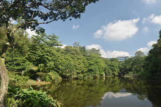
Dragonfly Pond
For a large metropolitan city Singapore is surprisingly well endowed with hiking opportunities, with perhaps one of the most celebrated being this route along the Southern Ridges, a small range of hills that overlook the dockyards and Sentosa Island.  It is not a continuous ridge but the city authorities have put in some ingenious engineering to overcome the challenges of dealing with the valleys that divide the hills.  The path is officially 10km in length but can easily be extended to include Labrador Park.  I also included Sentosa Island into the route for reasons that I shall explain later.  I began my route at Kent Ridge MRT station, which is the opposite end of the recommended route but walking from west to east always seems to make more sense to me.  It also ensured that I would see some of the highlights at the end of the route rather than at the beginning.

Kent Ridge View
From Kent Ridge station I took a left turn and another left turn to take me on to Science Park Drive, a wide road through what looked to be an area of hi-tech industry.  I was so taken with the shiny buildings that I missed the turn into the nearby park and only realised much further down the road when I came upon some tower blocks in the process of being demolished.  Such was the deliberate nature of the deconstruction that I could only assume that every available piece of concrete and metal were being recycled.  I wandered down into the adjacent park and soon found myself by the dragonfly pond.  I lingered here for a while watching the eponymous insects and enjoying the ambiance of the pond.  All was quiet in the park - I saw only a couple of joggers at this stage.

Friendly Lizard
I climbed up the steps and onto Kent Ridge proper where I got my first sight of the port.  When you are in the city the size of the port is not obvious but from up here you soon get a sense of why Singapore has become so fabulously wealthy.  The number of cranes and containers is quite bewildering and the scale of the port is not something I have really seen before.  I imagine that the docking fees and various tariffs is what keeps the country coffers topped up and why the local citizens are able to live such a good standard of life.  While admiring the view I also caught sight of a different kind of local - a small lizard observing me and making sure I wasn't going to be a threat.

Canopy Walk
I walked along the mostly empty car park to a mound further along that had a slightly elevated view of the port and from here I could see a wider aspect as well as a view back over the city for the first time.  This shaded area was far more popular with the locals and a couple of the tab;es were taken by professional people having work meetings - I imagine somewhere like that would be quite productive and popular.  A far cry from World War II when this ridge was held by a garrison hoping to repel the Japanese invaders who came in 1942.  One of the last battles for Singapore was fought here and the result made the British commanders that the game was up and they surrendered soon afterwards in what was one of the biggest defeats the British Army ever had.  Looking at the peaceful leisure surroundings now it is hard to believe that such a place could have such a bloody past.

Hort Park
The onward walk along Kent Ridge was a delight through a kind of arboretum (although it wasn't billed as such).  There were lots of different types of trees and although I couldn't really name any of them I did enjoy their different spreads, foliage and colours.  At the far end the ridge I went to look at Bukit Chandu War Memorial but sadly it was long term closed for renovations.  I met a chap who encouraged me to come again to visit when it's finished as he said it would be well worth it.  I left Kent Ridge here and walked along the tree top canopy walk to get to the next path.  Singapore does these walkways so well - they are all a treat and provide the walker with excellent opportunities to see the foliage and fruits/ flowers that would be impossible from ground level.  One tree I remember in particular was the gloriously named Tiup Tiup tree, a lanky one that is able to recolonise poor soils.  It had small fruits on it that I was able to reach out and touch courtesy of my lofty position.

Hort Park Butterfly
From the walkway it was also possible to see the Former Ford Factory (or at least its rough location for I couldn't really pick it out).  This is another of those iconic buildings in Singapore that is closely associated with the Japanese Occupation for it was in this old car works that the Allied commander, Lieutenant-General Percival surrendered to the Japanese and more than 2 years of occupation took place thereafter.  It is now a very interesting museum recounting this chapter of the war (I visited myself the following day).

Keppel Building
At the bottom of the zig zag canopy trail my eyes were drawn to a bird in the top of the tree above me.  It teased me a little with singing and hopping about just out of range of me being able to see it properly.  I tried and largely failed to get a decent picture of it but eventually gave up - I reckon I am a rubbish naturalist as I don't have enough patience.  It was a beautiful yellow colour though - easy to spot through the foliage. At the bottom of the hill I passed through a gate and into Hort Park.  I smiled as I entered as it hadn't previously occurred to me that this was in fact a horticulutual park where there was clearly quite a lot of research going on.  I soon became aware of hoards of kids too as they were all visiting on a school trip - I mostly gave them a wide berth as I tried to enjoy the peace and quiet of the flower gardens.  It was an exquisite place to wander around - the place was full of butterflies and other insects.  I had hoped that I might have some refreshment at the visitor centre but sadly it was closed on the day of my visit and I had to push on rather more quickly than I had hoped.

Arrival From Singapore
Just outside the garden was the graceful looking Alexandra Arch Bridge which connects this park to the next one at Telok Blanglah.  Apparently it looks particularly special after dark when all lit up.  However, before continuing on to there I decided to take a look at the alternate route that is offered by the parks service and explains why they suggest that the route is completed in the opposite direction.  If approaching from the other direction the suggestion is that the walker either chooses the Labrador Park option OR the Kent Ridge option.  Over-achiever that I am I wanted to do both, especially as I wasn't sure when I might get here again.  I turned right down Alexandra Road after the bridge, passing by a man who was sitting and selling nik-naks (mostly brushes).  This is a sight that I am used to in Thailand but not here - I think it is probably unusual outside the main ethnic areas of Chinatown and Little India.
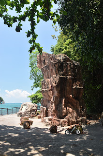
Dragon's Teeth
The walk down Alexandra Road wasn't that pleasant as it is a very busy road.  To be fair though the city authorities had provided a decent walkway and segregated cycle track.  I was feeling quite hot and bothered as I walked down towards Labrador Park and was very pleased when I saw a shopping centre on the way.  I dived in and had some lunch and enjoyed some air conditioning for a while before continuing onward.  I was pleased to see that there was a system of footbridges linking the shopping centre with the nearby MRT station for that was where I needed to go next.  Behind Labrador Park station is the Berlayer Creek boardwalk.  This was a rather different kind of experience for it passes through a mangrove creek where it is possible to observed wildlife.  To be fair I didn't see much other than the odd monitor lizard, squirrel and crow but that was probably due to the fact that I was now in the middle of the day and most creatures are too smart to be out then.  The mangroves did afford plenty of shade and this seemed to be a popular place for running for I passed many joggers along the way.


Harbour From Labrador Park
Eventually I came to the sea and the channel in front of me was quite popular with several hydrofoils making their way to and from Indonesia judging by the insignia they had on their paintwork.  Although there were of course plenty of people sitting in the park enjoying the warm weather rather bizarrely there were plenty of chickens wandering about too.  I turned right (although the left hand turn along more boardwalks looked equally if not more tempting) and headed towards Dragon's Teeth Gate where I came to the mouth of this particular part of the harbour.  On the opposite shore was the holiday island of Sentosa where I would eventually be headed.  The Dragon's Teeth Gate is an interesting feature as it just looks like a pile of random rocks.  The one that is there now is merely a replica - the original was destroyed by the British when widening the harbour  in 1848.  Just beyond it is an old light beacon and from there I surveyed the biggest number of ships I have ever seen in one place - literally dozens moored offshore awaiting their next assignment.
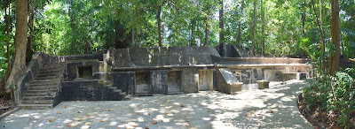
Former Battery
This was a different if no less interesting perspective of the harbour.  Across the way I could see the towering cranes and the hundreds of containers being swapped between ships and shore transport.  How on earth must it have looked before containers were invented or widely used?  The armies of people employed at these docks must have been unimaginable.  Now the only signs of people interesting with the water were a couple of fishermen fishing in spite of the signs forbidding it.  I looped around this very attractive waterfront park and then headed through the gatewa to the old hill where the wartime batteries can still be found.  This hill was one of the best defended in Sigapore - the only problem was that the guns were pointing out to sea and the enemy came from land via the Malayan jungles back in World War II.  This meant that the defenders were hopelessly ill-equipped to deal with what was a very fierce army.  Although the remains of the batteries are still well preserved any chance of them being used to defend the port would require a serious amount of vegetation and tree removing first as they are all seemingly just enclaves in the forest.  In one of the batteries there was a mock up showing how life must have been for the soldiers manning the guns.  At the top of the hill was supposed to be a viewpoint across the harbour but alas it was mostly blocked by trees.

Alexandra Bridge
At the top of the hill I rejoined the road and looped back around to Labrador Park MRT station and thence back to the shopping mall for a little relief from the hot sunshine.  I retraced my steps back up to Alexandra Bridge and turned right when I got there.  This led to the Forest Walk, another of those seemingly impossible canopy trails that led up to the top of the next ridge.  This one was supposed to be 1500 metres long but it seemed a lot longer.  It was surprisingly quiet - only the odd walker using it.  I heard a lot of bird life as I walked it but in all honesty I don't remember seeing much of it, except for one of those yellow birds which I got a better look at this time.  I learned that it was a black-naped oriole, one of the most common birds that live in parks in Singapore.

Henderson Waves View
The canopy walk seemed to take a while to reach the top of the ridge, not that I was in any hurry for it was the most delightful exploration of the forest.  Singapore really has mastered the art of keeping nature close to city life - I cannot think of too many other cities that have done this quite so well.  It is possible in places to imagine that you are deeper in the jungle than you actually are - with the vibrant city in some cases only a few hundred metres away.  At the top of the hill I came to Telok Blangah Hill Park and initially I walked along a quiet road to a car park not too much further on.  As I did so I became away of a lot of monkey movement in the adjacent part of the forest.  I was relieved when it died down - I didn't much like the idea of being 'mugged' by these creatures who seem to be conditioned to steal food, sunglasses, cameras and any number of loose items.

Henderson Waves
At the car park my onward path was marked by the most amazing tree - it wasn't especially tall but had the most amazing wide spread.  Just before it I passed the most famous house on the hill - the Alkaff Mansion.  This old place is famous as a wedding venue these days and although normally photogenic there was a sign outside asking people not to take pictures as it wasn't at its best during renovations.  I imagine they didn't want any illusions shattered!  From the big tree I had to climb again in order to reach Henderson Waves, an astonishing $25million bridge across to Mount Faber Park.  It is audaciously designed with seven undulating curved steel ribs and built of a locally sourced timber that can deal with everything a tropical climate can throw at it.  The bridge is almost impossible to photograph properly while you are crossing it - you just have to appreciate the engineering as you go.

Cable Car
At the far side of Henderson Waves I was now at Mount Faber Park and the views across to Sentosa Island seemed to make it more appealing.  I determined that if the cable car wasn't too expensive I would try it out.  However when I got to the Mount Faber station I was quoted a price that I thought a bit steep.  I walked away thinking that I wouldn't do it but then changed my mind, went back and was rather pleased when I was offered a discount.  That definitely sweetened the pill and I was soon travelling across in a cabin all on my own - the view across the city was awesome and well worth the price of the ticket.  The first stop on the cable car is a shopping centre and rather bizarrely the station is on the top floor.  The route then continues across the harbour to the island where it drops you right in the heart of all the holiday entertainment.  Sentosa is where Singapore likes to party and there are theme parks, resorts, beaches, all manner of thrillseeker sports and everything you might want from a holiday.

Sentosa View
I took the other cable car that took me to the far end of the island.  I wanted to see a different Sentosa - the old fort that was built to defend it during World War II.  It was a fascinating visit, which I just about managed to squeeze in before the old place closed for the day.  Inside the fort you can see the living quarters, gun batteries, medical centre and various other reconstructed areas and including sound effects that helped you imagine what it must have been like for the defenders.  It is a part of Sentosa that most probably don't come to and I pretty much had it to myself.  I did find it very moving there though - certainly a different experience than the World War II places I'm used to back in Europe.  Once I'd looked around I sensed that it was going to get dark soon and so I went straight back to the cable car and did the two stage journey all the way back to Mount Faber.  I probably could have got off at Harbourfront but I decided to complete the whole journey and was back at Mount Faber in the now fading light (it gets dark very quickly in the tropics)

Mock Up Fort at Sentosa Island
In fact by the time I did get back and walk down the steps to Harbourfront station it was already growing dusk.  I even managed to miss the sunset!  Nevertheless I was pleased that I hadn't come up this way - it would have been quite a stiff climb at the beginning and my route was definitely gentler.  Harbourfront was a more convenient getaway point too - closer to the city centre.

Returning From Sentosa Island
I loved this walk - so much history, architecture, wildlife, forest and views all rolled into one.  Although it seemed a modest length I worked out that after all the additional stretches that I did it was actually 18km in length!  I probably drank my body weight in water during the day; something to factor in when trying to do any walks in the tropics even when surrounded by a big city.
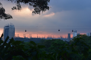
Final View From Mount Faber