Posts tagged ‘Rocks’

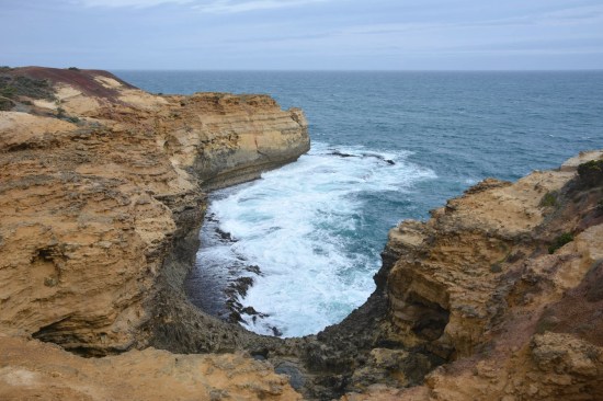
A few weeks ago we drove along the Great Ocean Road, where the limestone plateau of western Victoria falls into the sea, leaving behind remnant limestone stacks, arches and gorges. As we drove from the western end back towards Melbourne we didn’t quite make it as far as the famous 12 Apostles (or however many are left standing) but there were plenty of coastal features still to see.

OCG-215OCG-229OCG-268

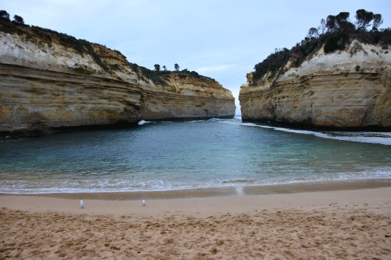
Loch Ard Gorge, named after a ship which was wrecked within the bay many years ago.

OCG-259OCG-245OCG-241Panorama_14Panorama_13

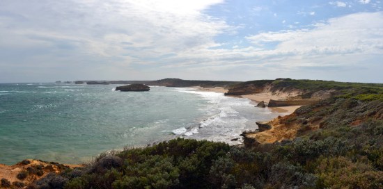
At the far western end of the Great Ocean Road the limestone cliffs eventually become beaches with steep dunes.

Panorama_12

There used to be another limestone arch forming a natural bridge between the main cliff on the left and the island on the right but it fell into the sea and the sight is now known as London Bridge.

Panorama_11

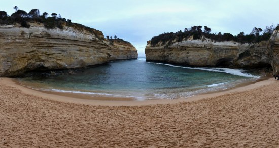
Travelling the Great Ocean Road in the cooler months and on a grey overcast day meant there weren’t too many tourists to get in the way of your photos.

Leave a comment

Spitzkoppe (also known as the Matterhorn of Namibia) is a set of bald granite peaks that easily stand out in the landscape of the flat Namib Desert. The 700 million year old granites rise up to 700 metres above the surrounding desert plains and make a fantastic focal point in the landscape. We camped at the base of Spitzkoppe one night and witnessed a magnificent sunset disappearing behind the granite shapes.
spitzkoppe_namibia_africa_granite_rock_outcrop_boulder spitzkoppe_namibia_africa_granite_rock_outcrop_boulder_10

Rock Hydrax (or Rock Dassies) were the only animals we saw wandering amongst the rocks.

spitzkoppe_namibia_africa_granite_rock_outcrop_boulder_rock_dassie_hyrax spitzkoppe_namibia_africa_granite_rock_outcrop_boulder_9 spitzkoppe_namibia_africa_granite_rock_outcrop_boulder_8 spitzkoppe_namibia_africa_granite_rock_outcrop_boulder_7 spitzkoppe_namibia_africa_granite_rock_outcrop_boulder_6 spitzkoppe_namibia_africa_granite_rock_outcrop_boulder_5

Whilst the sun set over to the west, a storm rolled in from the east and we had a wet evening huddle in tents.

spitzkoppe_namibia_africa_granite_rock_outcrop_boulder_12 spitzkoppe_namibia_africa_granite_rock_outcrop_boulder_4 spitzkoppe_namibia_africa_granite_rock_outcrop_boulder_3 spitzkoppe_namibia_africa_granite_rock_outcrop_boulder_desert_lizard spitzkoppe_namibia_africa_granite_rock_outcrop_boulder_11 spitzkoppe_namibia_africa_granite_rock_outcrop_boulder_2 spitzkoppe_namibia_africa_granite_rock_outcrop_boulder_sunset_3 spitzkoppe_namibia_africa_granite_rock_outcrop_boulder_sunset_2 spitzkoppe_namibia_africa_granite_rock_outcrop_boulder_sunset

Leave a comment

The Kuiseb River runs through the south of Namibia. The western end of the river acts as a border for the sand dunes

of the Namib Desert, whilst the eastern end of the river has carved a canyon into the rocky landscape. The rivers water

is not always visible but the river bed can be identified by the presence of trees.

scenic_flight_kuiseb_canyon_namib_desert_end_orange_yellow_sand_dunes scenic_flight_swakopmund_kuiseb_river_canyon_namib_desert_sand_dunes_trees scenic_flight_kuiseb_river_canyon_namib_desert_end_orange_yellow_sand_dunes scenic_flight_swakopmund_kuiseb_river_canyon_namib_desert_sand_dunes_orange_desert_rocks scenic_flight_swakopmund_kuiseb_canyon_namib_desert_sand_dunes_orange_desert_rocks scenic_flight_swakopmund_kuiseb_canyon_river_canyon_namib_desert_sand_dunes_trees scenic_flight_swakopmund_kuiseb_canyon_namib_desert_sand_dunes_orange_river_oasis scenic_flight_swakopmund_kuiseb_river_canyon_namib_desert_rocky_outcrop scenic_flight_kuiseb_canyon_namib_desert scenic_flight_swakopmund_kuiseb_canyon_namib_desert_rocky_outcrop

Not only was the Kuiseb Canyon and River viewed from a scenic flight over the Namib Desert but we also

drove through the canyon and stopped for a quick look.

kuiseb_canyon_south_namibia_africa_rocks kuiseb_canyon_south_namibia_africa kuiseb_canyon_south_namibia_africa_outcrop_rocks_shale kuiseb_canyon_south_namibia_africa_outcrop_rocks kuiseb_canyon_south_namibia_africa_rocks_shale

Leave a comment

Hidden away in the desert lands of southern Namibia is the Fish River Canyon, Africa’s largest canyon

and second in size to the Grand Canyon. The canyon stretches approximately 160km along

the Fish River, spreads up to 27km in width and drops to 550m deep in some places.

fish_river_canyon_namibia_africa_second_largest_quartzite_desert_horseshoe_river_bend_sunset copy

fish_river_canyon_namibia_africa_second_largest_quartzite_desert_brown_orange_outcrop copy

fish_river_canyon_namibia_africa_second_largest_quartzite_desert_gorge_fish_river_stream copy

fish_river_canyon_namibia_africa_second_largest_quartzite_desert_horseshoe_river_bend_rim_walk_sunset copy

fish_river_canyon_namibia_africa_second_largest_quartzite_desert_river_gorge

fish_river_canyon_namibia_africa_second_largest_quartzite_desert_horseshoe_river_bend copy

It was ~350 million years ago when the canyon began to form as the Fish River

started to erode through the quartzite layers of Nama group before eroding

its way through the convoluted gneisses of the Namaqualand Metamorphic Complex.

fish_river_canyon_namibia_africa_second_largest_quartzite_desert_outcrop copy

fish_river_canyon_namibia_africa_second_largest_quartzite_rock_desert_wide_rock_pile_rim_walk copy

fish_river_canyon_namibia_africa_second_largest_quartzite_desert_rock copy

fish_river_canyon_namibia_africa_second_largest_quartzite_desert_steep_cliff_rim_walk copy

fish_river_canyon_namibia_africa_second_largest_quartzite_desert_rock_cairn_pile copy

fish_river_canyon_namibia_africa_second_largest_quartzite_desert_river_bend copy

fish_river_canyon_namibia_africa_second_largest_quartzite_desert_river_gorge copy

fish_river_canyon_namibia_africa_second_largest_quartzite_desert_rim_walk copy

fish_river_canyon_namibia_africa_second_largest_quartzite_desert_quiver_tree_rock_pile copy

We arrived in the late afternoon to avoid the summer heat and did a short rim walk along the edge of the

canyon (along the eastern edge in the northern section of the canyon) before watching the sunset over the canyon.

fish_river_canyon_namibia_africa_second_largest_quartzite_desert_brown_orange_yellow_sunset_rim_walk

Leave a comment

Continuing along the Jurassic Coast from Durdle Door and Man O’ War Bay is Lulworth Cove.

jurassic_coast_dorset_england_lulworth_cove_geology_stratigraphy_limestone_chalk_3

It is composed of the same geological strata found around Durdle Door and the cove itself is carved

from the limestone that forms the cliffs neighbouring Durdle Door.

jurassic_coast_dorset_england_lulworth_cove_geology_stratigraphy_limestone_chalk_4 jurassic_coast_dorset_england_lulworth_cove_geology_stratigraphy_limestone_chalk_5

The water turns a milky blue as the cliffs slowly erode away and form a beach full of white pebbles.

  jurassic_coast_dorset_england_lulworth_cove_geology_stratigraphy_limestone_chalk_10 jurassic_coast_dorset_england_lulworth_cove_geology_stratigraphy_limestone_chalk_6 jurassic_coast_dorset_england_lulworth_cove_geology_stratigraphy_limestone_chalk_9

In the next little cove is the Lulworth Crumple. A near vertical set of strata, resulting from

folding of the Purbeck Stone (a series of thin layers of Limestone and Clay).

jurassic_coast_dorset_england_lulworth_cove_geology_stratigraphy_limestone_chalk_2 jurassic_coast_dorset_england_lulworth_cove_geology_stratigraphy_limestone_chalk_8 jurassic_coast_dorset_england_lulworth_cove_geology_stratigraphy_limestone_chalk jurassic_coast_dorset_england_lulworth_cove_geology_stratigraphy_limestone_chalk_7

More information on the geology can be found here.

Leave a comment