Early on October 15, 1987, an innocuous low-pressure system was moving across the Bay of Biscay off the west coast of France. Within one day, it became one of the most strongest windstorms in European history. Poorly anticipated, the storm produced hurricane-force sustained winds for hours over portions of Great Britain and France as well as absurdly strong gusts. The highest measured during the storm was 135 mph, corresponding to category 4 on the hurricane Saffir-Simpson scale (the cyclone was not tropical, however, so the word "hurricane" did not apply). Subsequently known simply as the "Great Storm of 1987," it prompted further study of the mechanisms by which extratropical storms produce extreme winds.
The above satellite image shows the Great Storm of 1987 with a long frontal "tail" extending all the way down to the Canary Islands.
By the time of the Great Storm, the overall genesis process for extratropical cyclones was well understood. The energy for extratropical cyclone formation ultimately derives from temperature differences: cold air from the polar regions meets warm air from the subtropics, usually between 30 and 60 degrees latitude north and south. At these interfaces, there are differences in air pressure at the same altitude in the atmosphere since cold air is denser than warm. This instability provides the energy to drive cyclone formation.
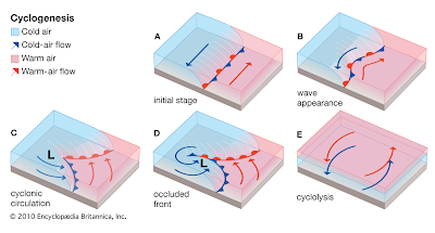
Under the right circumstances, small perturbations in the flow along a boundary of air masses can trigger the formation of a low-pressure system, as indicated above. The cyclonically rotating boundaries between warm and cold air become the warm and cold fronts that control weather in the mid-latitudes. Note that all diagrams, including that above, are the correct orientations in the Northern Hemisphere: the directions of spin would be reversed south of the equator. Our concern in this post is investigating where the strongest surface winds occur in these extratropical storms.
The above schematic shows major low-level winds associated with an extratropical cyclone at different stages of development. These are typical of a rapidly developing and strong storm, which is assumed to be moving northeast. As the storm ramps up, the dominant feature is the mild and wet Warm Conveyor Belt (WCB). This feeds the center a supply of moisture; indeed, nearly all the precipitation occurs ahead (east) of the advancing cold front boundary. Windy conditions can accompany the WCB, but they are not usually too extreme.
In the wake of the cold front comes the chilly and dry Cold Conveyor Belt (CCB). Most intense in a mature storm, this feature often packs stronger winds than the WCB, though they occur after precipitation has passed. Both of these are large-scale, well-understood features, but could not account for the unusually strong surface winds observed in some rapidly intensifying storms. It is the third feature above that fills in the gap: the so-called Sting Jet (SJ).
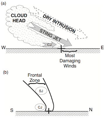
Named for the "sting at the end of the tail", the sting jet occurs near the very tip of the cloud head, where the bent-back cold front in the diagram above ends. This feature occurs most commonly in cyclones that explosively intensify or "bomb cyclones". The technical definition for this is a pressure drop of 24 mb or more in a period of 24 hours. As shown in the diagram below, just east of this "tail" of the cloud structure, instability causes dry air to descend from high in the atmosphere. Below this is the sting jet. It is a smaller feature compared to the CCB and WCB, about 100 km wide instead of several hundred. This conveyor belt of air is pushed toward the ground by the intruding dry air above.
Typically, friction with the land (or ocean) keeps winds near the surface lower than the strongest winds a few thousand feet above sea level. However, the descending site jet can transport these strong winds quickly to the surface. Moreover, the sting jet comes just head of the CCB (written CJ in the above picture) out of the south or southwest. In a cyclone moving northeast, these winds align with the storm's direction of motion, boosting them even higher. The result: localized but extremely intense wind gusts at the ground, associated with little to no precipitation.
Nearly all documented examples of sting jets are associated with north Atlantic storms impacting Europe. Since the Great Storm of 1987, roughly a dozen more examples have been positively identified. Satellite data indicate that further events likely occur over water where surface observations are sparse. Few studies have investigated the occurrence of sting jets elsewhere around the world, but explosive intensification of extratropical cyclones also occurs in the northwest Pacific and near Antarctica. Fortunately, comparable events in these regions have far fewer human impacts.
A thorough survey of the causes of sting jets is beyond the scope of this post; however, our understanding of this phenomenon is far from complete. Computer models struggle to resolve the feature, especially its tendency to "fan out" in to many small jets near the surface. As a result, predicting these events is still difficult. There is a lot on the line: the Great Storm of 1987 killed 22 people and caused billions in damages. Hopefully, future advances in advance warning will avert the worst impacts of these powerful storms.
Sources: https://journals.ametsoc.org/jcli/article/30/14/5455/97090/Sting-Jet-Windstorms-over-the-North-Atlantic, https://www.metoffice.gov.uk/weather/learn-about/weather/types-of-weather/wind/sting-jet, https://rmets.onlinelibrary.wiley.com/doi/abs/10.1256/qj.02.143, https://rams.atmos.colostate.edu/at540/fall03/fall03Pt5.pdf, https://www.britannica.com/science/cyclogenesis, https://rmets.onlinelibrary.wiley.com/doi/pdf/10.1002/qj.3267
Showing posts with label Meteorology. Show all posts
Showing posts with label Meteorology. Show all posts
Friday, January 1, 2021
Sunday, March 1, 2020
The Hurricane Graveyard
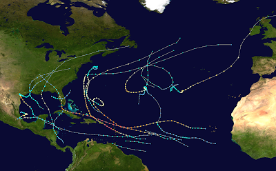
The Caribbean Sea appears to be a fertile area for the genesis and development of hurricanes: it lies at a tropical latitude, with warm ocean waters averaging over 80° F (26.7° C) for most of the year, including hurricane season (which extends from June to November). Warm water is essential to the development of hurricane, as it feeds warm moist air updrafts into burgeoning thunderstorms. However, during some hurricane seasons, the track map looks something like this:
The above image shows the tracks of all the tropical cyclones during the 2017 Atlantic hurricane season. Despite this season being extremely active and devastating, there is a "hole" in the map over the Caribbean, especially the eastern portion. No cyclones developed in 2017 in the eastern Caribbean and the ones that entered this region died out (though Harvey ultimately regenerated further west, with horrific consequences). This particular season was cherrypicked, but this phenomenon is sufficiently common and well-known to the meteorological community that the eastern Caribbean is sometimes known as the "Hurricane Graveyard".
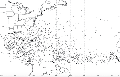
Statistics confirm that the Hurricane Graveyard is more than just weather lore. Consider the diagram below, which shows the point of genesis for all known "in-season" (June to November) tropical cyclones between 1851 and 2008:
It is clear that, relative to other areas at the same latitude, the eastern Caribbean churns out far fewer tropical cyclones. What is more, tropical cyclones often unexpectedly weaken or dissipate as they pass through it, contrary to the expectations of many computer models and forecasts (however, models do fairly well at predicting the scarcity of genesis in the eastern Caribbean, see this article). So why does the Hurricane Graveyard exist?
A 2010 study examined some the factors that contribute to this phenomenon. One of these is the Caribbean low-level jet (CLLJ). Low-level jets are channels of fast-moving air in the low levels of the atmosphere near the surface (analogous to jet streams, which are much stronger and at higher altitudes). The CLLJ blows east to west over the Caribbean, with the strongest winds occurring near its center, especially during July when the CLLJ reaches its peak. The winds moderate and reach a relative minimum by October, coinciding tellingly with a somewhat greater rate of tropical cyclone formation in the east Caribbean.
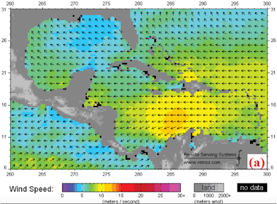
The above image shows the low-level winds in the Caribbean region averaged over the month July 2006. As the diagram indicates, wind speeds in excess of 10 m/s (22 mph) are typical during that time of year. These winds are due in part to the Azores-Bermuda high pressure system, a persistent area of dry, sinking air over the central subtropical Atlantic around which air flows clockwise. The southwestern portion of clockwise flow is evident in the diagram above. But why do horizontal winds of this sort inhibit tropical cyclone development? Further, the peak winds occur toward the center of the Caribbean, whereas our area of interest lies to the east, so what gives?
The key concept explaining the hurricane graveyard is low-level divergence. Divergence is simply a measure of to what degree air (or any fluid) is flowing out of a region. Two schematic vertical cross-sections of the atmosphere are shown below.
In the first, there is low-level divergence, as air is flowing outward from the central region. Since any outgoing air must be replaced, this air can only come from above, creating downdrafts and convergence (the opposite) at the atmosphere's upper levels. The reverse occurs in the second diagram. One may note that our diagram of Caribbean winds does not show air moving outward from any central point. However, the CLLJ accelerates moving east to west across the eastern portion of the sea, so it is still a situation where more air is leaving this region in the lower levels than is entering it. Hence the eastern Caribbean exhibits low-level divergence!
Crucially, low-level divergence is the opposite of what hurricanes need to thrive. Thunderstorm activity is driven by rising moist air and killed by sinking dry air. The divergence caused by the CCLJ often causes the thunderstorms associated with tropical cyclones or disturbances to collapse when they pass over the region, at last accounting for the Hurricane Graveyard.
Recent analyses have shed even more light on this phenomenon. It peaks in July when the CCLJ does, diminishing toward the end of hurricane season. Indeed, the rate of cyclonogenesis in the eastern Caribbean more closely resembles that of the rest of the basin from October onward. In addition, the Hurricane Graveyard effect is more pronounced in summers with an El Niño, when the Azores-Bermuda high is farther west and stronger, leading to a more powerful CCLJ. This effect illustrates how there is a great deal more to hurricane formation than humid air and warm water. Several other atmospheric factors, including low-level divergence, feature crucially in understanding and forecasting the development of tropical cyclones.
Sources: https://journals.ametsoc.org/doi/abs/10.1175/2009BAMS2822.1, https://journals.ametsoc.org/doi/full/10.1175/WAF-D-13-00008.1, https://journals.ametsoc.org/doi/pdf/10.1175/2011JCLI4176.1, http://www.atmo.arizona.edu/students/courselinks/fall16/atmo336/lectures/sec1/winds_fall15.html
Labels:
Meteorology
Saturday, February 1, 2020
Atmospheric Rivers
The transport of water vapor in the atmosphere is responsible for the world's weather. As such, tracking the movement of water-laden air masses is essential to weather forecasting. By the mid-1990's, satellite measurements had documented that the flow of moisture through the atmosphere often occurs in very high volumes through very narrow channels. These phenomena were named atmospheric rivers, because the amount of water they transport is comparable to that of Earth's largest rivers.
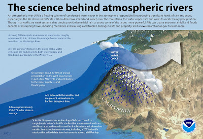
The above graphic (click to enlarge) summarizes the basics of atmospheric rivers. The most well-known example, as indicated above, delivers water vapor from near the equator to the western coast of north America, especially California. This phenomenon is the source of a large portion, if not a majority, of precipitation in these regions when moist air is forced upward over the Sierra Nevada mountains.
The formation of a specific atmospheric river event often occurs when a strong extratropical cyclone moves away from the equator toward higher latitudes, dragging warm equatorial air in its wake. This paper analyses the role such cyclones have in driving atmospheric rivers, focusing on a case study of a powerful February 2002 cyclone. This cyclone formed in the north Atlantic and moved northeastward, passing west of the British Isles before ultimately dissipating in the Barents Sea north of Scandinavia. At its peak intensity, it bottomed out at 935 mb, a pressure comparable to that of a category 4 hurricane!
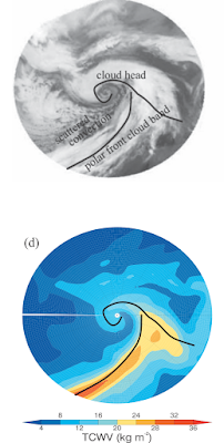
The above shows the cloud pattern of the cyclone on an infrared satellite view (top) and a diagram showing total column water vapor (TCWV, bottom) in the same region. Unlike for hurricanes, most of the extratropical storm's water vapor is concentrated in a linear feature far from the center and extending south and west. The counterclockwise rotation of the large circulation in the northern hemisphere draws a long train of warm, tropical air northward, and it is here that the atmospheric river sets up.
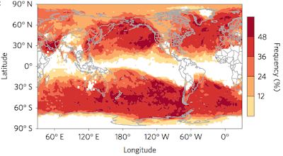
In practice, meteorologists detect atmospheric rivers using satellite imagery, which can detect the transport of water vapor in the atmosphere, and the threshold for being an atmospheric river depends on the integrated water vapor transport (IVT) value in a given region. This is calculated by adding up the flow of moisture in different layers of the atmosphere. Using these tools, the frequency/severity of such events across the world has recently been analyzed.
The above map shows the percentage of severe surface precipitation events are associated with atmospheric rivers in different locations across the world over the period 1997-2014. Only precipitation events ranking in the top 2% for a given region are considered. Therefore, the map shows where atmospheric rivers have the greatest impact: mostly over the ocean, but also in portions of western North America, southern South America, central Asia, and eastern Australia. They also are associated with extreme wind events over many of the same regions. As a result, atmospheric rivers are responsible for many of the most damaging flooding events across the globe. Better understanding their formation and evolution will improve our ability to forecast and respond to flooding events in the future.
Sources: https://web.archive.org/web/20100610035058/http://paos.colorado.edu/~dcn/ATOC6020/papers/AtmosphericRivers_94GL01710.pdf, https://noaa.gov, https://journals.ametsoc.org/doi/pdf/10.1175/BAMS-D-14-00031.1, http://cw3e.ucsd.edu/wp-content/uploads/2018/02/WaliserGuan-ngeo2894.pdf
Labels:
Meteorology
Wednesday, January 1, 2020
Upper Atmospheric Clouds
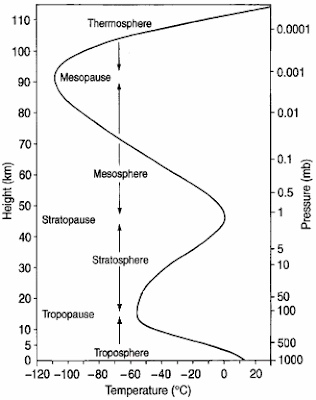
Weather is caused by the atmosphere. However, most of what we know as weather is limited to the atmosphere's lowest layer, the troposphere. The height of the troposphere varies with latitude on the Earth, from under 4 miles (6 km) in the coldest polar regions to over 10 miles (16 km) at the equator. The distinguishing feature of this layer that allows weather to occur is cloud formation.
Cloud formation occurs when water, evaporated from the ground into gaseous water vapor, condenses into small water droplets in the atmosphere. However, the water vapor-laden air must have some means by which it is transported upward. One such means is orthographic cloud formation.
This occurs when the wind direction pushes air up the slope of a topographical feature such as a mountain. As air rises, it expands and cools. Since cooler air holds less water vapor, condensation begins, clouds form, and precipitation can follow. Another impact of this process is that the opposite side of the mountain from the prevailing wind can be very dry.
However, clouds of course also form in the absence of mountainous terrain. This occurs when a parcel of air near the surface, containing evaporated water, is heated by the warm sunlit ground. Warmer than the adjacent atmosphere, it rises. As the air rises, its pressure drops in accord with that of its surroundings (air pressure decreases with altitude, a phenomenon mountain climbers are familiar with). By the ideal gas law, the pressure of a gas is proportional to its temperature. Therefore, a rising parcel of air cools.
The tallest clouds form in the case of absolute instability, illustrated above (click to enlarge). The parcel of air begins at the ground at a temperature of 40° C. As it rises, it cools. However, in the unstable case, the air temperature of the ambient atmosphere drops more quickly than the temperature in the rising parcel of air (the rate of its cooling is known as the dry adiabatic lapse rate). As a result, the cooling air nevertheless remains warmer than its surroundings and continues to rise. Eventually, its becomes too cold to hold all of the water vapor and condensation begins at the condensation level. Condensation releases heat to the atmosphere, so the temperature decrease of the parcel slows (to what is known as the wet adiabatic lapse rate). The resulting condensation forms a cloud, whose lower extremity is the condensation level.
At the top of the above diagram, the parcel temperature is still much higher than the atmospheric temperature, so the air rises yet more, continuing to increase the height of the cloud on the way. In situations such as this, a cumulonimbus cloud may form.
Cumulonimbus can extend from a few thousand feet from the ground over 10 miles (16 km) upward. It is these clouds that are responsible for many types of extreme weather, including severe thunderstorms, hail, and even tornadoes. However, even for these enormous clouds, there is an limit to their upward growth: the tropopause. The tropopause is the boundary between the troposphere below and the next layer of the atmosphere, the stratosphere, above. As indicated at the beginning of the post, the height of the tropopause varies with latitude. It is characterized by a reversal of the decline in temperature with height that takes place up to this point. Beginning at the tropopause and into the stratosphere, temperature again begins to increase with height (as shown near the bottom of the figure below).
Unlike in the troposphere, where the only significant source of heat was the sun-heated surface below, the stratosphere derives heat from another source: the absorption of solar ultraviolet radiation by the ozone layer. Oxygen and ozone (O3) molecules interact with incoming ultraviolet rays, impeding their passage to the Earth's surface and therefore protecting it from most of this harmful radiation. In the process, they absorb heat. The result of all this is that air just above the tropopause is always stable: temperature increases with height. Rising parcels of air do not penetrate much past this point. Rather, they spread out laterally, forming the anvil top characteristic of cumulonimbus clouds and illustrated above. By virtue of their momentum, a few parcels enter a bit into the stratosphere; this is the "overshooting top" in the diagram.
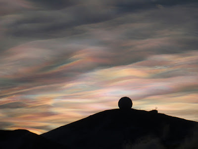
However, in rare cases, clouds can form outside the troposphere. For example, polar stratospheric clouds (PSCs) may sometimes form in high latitude regions. They occur in the lower stratosphere, at altitudes varying from 6 to 15 miles (10-25 km), where temperatures plummet to below -100° F. At these especially low temperatures, water vapor can condense directly into ice crystals. The more spectacular PSCs are the nacreous clouds, which are composed entirely of these crystals. They are most visible just after sunset when the Sun has disappeared below the horizon on the ground but still illuminates the stratosphere. The ice crystals diffract light, producing beautiful iridescent displays.
This image shows nacreous clouds over McMurdo Station, Antarctica. Though they are most often seen over that continent, they also appear occasionally over northern Europe, North America, and Russia. PSCs are of scientific interest because they can serve as sites for chemical reactions that destroy ozone. Understanding the climatology of these unusual clouds helps to monitor the regional variation of ozone in polar regions.
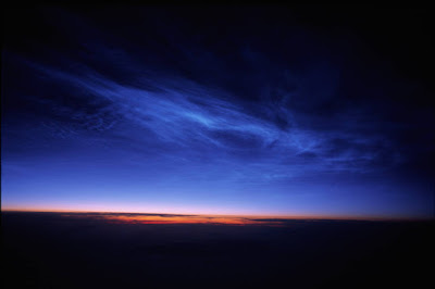
In addition to PSCs, there is another type of upper atmospheric cloud that occurs even at even higher altitudes. Noctilucent clouds, so named because they are only visible at night well after the Sun has passed below the horizon, form in the mesosphere. This layer is defined as being the second region where temperature decreases with height. The clouds form generally around 50 miles (80 km) above the surface. Though not fully understood, it is thought the formation of noctilucent clouds is due to meteoric dust. This dust is the result of small objects from space breaking up upon entering Earth's atmosphere and serves as a site for the formation of ice crystals. Though the amount of moisture water vapor this high is minuscule, the temperature here can plummet to a frigid -180° F at high latitudes, supporting ice crystal formation.
The above image, taken from Nunivak Island, Alaska, shows noctilucent clouds after sunset. These clouds are at such a high altitude that they reflect sunlight from below the horizon back down to Earth. Studying the locations where these clouds form can reveal concentrations of dust (meteoric or from other sources such as volcanoes) in the mesosphere as well as shed light on how the upper atmosphere changes with the climate. Apart from their scientific value, upper atmospheric clouds join the aurorae as some of the most beautiful displays to be found in polar skies.
Sources: The Encyclopedia of Weather and Climate Change by Juliane Fry, https://www.wunderground.com/cat6/Methane-Giving-Noctilucent-Clouds-Boost?cm_ven=hp-slot-1, http://www.richhoffmanclass.com/chapter4.html, https://www.nasa.gov/mission_pages/sunearth/science/atmosphere-layers2.html, https://www.atoptics.co.uk, https://www.nasa.gov/multimedia/imagegallery/image_feature_680.html, https://www.sciencedaily.com/releases/2014/04/140411091939.htm
Labels:
Meteorology
Tuesday, February 12, 2019
Ocean Currents and the Thermohaline Circulation
Ocean currents are ubiquitous and familiar. Beach goers are wary of tidal currents, as well as those caused by weather systems. Currents caused by tides and weather are constantly changing and chaotic. However, under this noise exists a larger-scale and more orderly system of circulation. By averaging over long time periods (in effect screening out the noise of short-term fluctuations), larger currents such as the Gulf Stream, which brings warm water northward along the east coast of the United States, appear. Another example is the California current, which brings the cold waters of the north Pacific down along the west coast. But why do these currents exist? Some patterns may be seen if we expand our view to the world as a whole.
The above image shows major surface ocean currents around the world. Note that despite geographical differences, some currents in each ocean in each hemisphere follow the same general pattern, flowing east to west in the tropical latitudes, toward the poles on the western edge of ocean basins, west to east at mid-latitudes, and finally toward the equator on the eastern edges. These circular currents are known as subtropical gyres. For example, the Gulf Stream is the western poleward current in the north Atlantic subtropical gyre and the California current the eastern current toward the equator in the north Pacific tropical gyre. These exist largely due to the Earth's prevailing winds.
The prevailing winds at the Earth's surface fit into a larger dynamic atmospheric pattern. The greater heating of the tropics as compared to the polar regions and the rotation of the Earth lead to the formation of three atmospheric cells in each hemisphere. The winds in these cells rotate due to the Coriolis effect (in essence the fact that straight paths appear to curve from the viewpoint of an observer on a rotating planet), producing east to west winds in the tropics and polar regions, and west to east winds in the mid-latitudes. Look back at the subtropical gyres on the map of currents. Notice that the currents labeled "equatorial" follow the trade winds, and the north Pacific, north Atlantic, etc. currents follow the prevailing westerlies. The west and east boundary currents then "complete the circle" and close the flow. This is no coincidence. It is friction between air and water that drives subtropical gyres: the force of wind tends to make water flow in the same direction. Another important example is the Antarctic circumpolar current, the largest in the world. Since there are no landmasses between roughly 50°S and 60°S latitude, the westerlies drive a current unimpeded that stretches all the way around the continent of Antarctica. Many other currents in the global diagram are responses to these main gyres, or are connected to prevailing winds in more complicated ways.
This system of ocean currents has profound impacts on weather and climate. Due to the Gulf Stream, north Atlantic current, and its northern extension, the Norwegian current, temperatures in northwestern Europe are several degrees warmer than they would otherwise be.
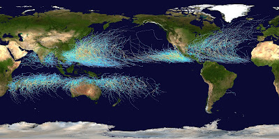
The above image illustrates one of the influences of ocean currents on weather. It shows all tropical cyclone tracks (hurricanes, typhoons, etc.) worldwide from 1985-2005. Since tropical cyclones need warm ocean surface waters to develop, the cold California current helps to suppress eastern Pacific hurricanes north of 25° N or so. In contrast, the warm Kuroshio current in the western Pacific allows typhoons to regularly affect Japan, which is at a higher latitude. Note also the presence of cyclones in the southwest Pacific and the lack of any formation in the southeast Pacific (though very cold surface waters are only one of several factors in this).
Despite their vast impact, which goes well beyond the examples listed, all of the currents considered so far are surface currents. Typically, these currents exist only in the top kilometer of the ocean, and the picture below this can look quite different.
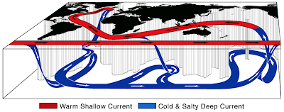
The above image gives a very schematic illustration of the global three-dimensional circulation of the oceans, known as the thermohaline circulation. The first basic fact about this circulation, especially the deep ocean circulation, is that it is slow. Narrow, swift surface currents such as the Gulf Stream have speeds up to 250 cm/s. Even the slower eastern boundary currents often manage 10 cm/s. In contrast, deep ocean currents seldom exceed 1 cm/s. Their tiny speed and remoteness makes them extremely difficult to measure; in fact, rather than directly charting their course, the flow is inferred from quantities called "tracers" in water samples. Measurements of the proportion of certain radioactive isotopes, for example, are used to calculate the last time a given water sample "made contact" with the atmosphere.
The above graphic illustrates the age of deep ocean water around the world. The age (in years) is how long it has been since a given water parcel came to equilibrium with the surface. Note that the thermohaline circulation occurs on timescales of over 1000 years. This information indicates that deep water formation (when water from the surface sinks) takes place in the North Atlantic but not the North Pacific, as indicated in the first graphic. This is because all the deep waters of the Pacific are quite "old". Deep water formation also occurs in the Southern Ocean, near Antarctica. In both cases, the mechanism is similar: exposure to frigid air near the poles makes the surface waters very cold, and therefore dense. Further, in winter, sea ice forms in these cold waters, leaving saltier water behind (since freshwater was "taken away" to form sea ice). This salty, cold water is denser than the ocean around it and it sinks. The newly formed deep water can flow near the bottom of the ocean for hundreds of years before coming back to the surface.
One climatological influence of this phenomenon is the ocean's increased ability to take up carbon dioxide. Most of the carbon dioxide emitted by human industry since the late 1800s has dissolved in the oceans. Since deep water takes so long to circulate, increased CO2 levels are only now beginning to penetrate the deep ocean. Most ocean water has not "seen" the anthropogenic CO2 so it will continue to take up more of the gas for hundreds of years. Without this, there would much more carbon dioxide in the atmosphere, and likely faster global warming.
The network of mechanisms driving ocean currents and the thermohaline circulation is quite intricate, and we have only touched on some of them here: weather systems, prevailing winds, differences in density, etc. There are many more subtleties as to why the ocean circulates the way it does. The study of these nuances is essential for fully understanding the Earth's weather and climate.
Sources: Atmosphere, Ocean, and Climate Dynamics: An Introductory Text by John Marshall and R. Alan Plumb, https://www.britannica.com/science/ocean-current, http://www.seos-project.eu/modules/oceancurrents/oceancurrents-c01-p03.html
Labels:
Meteorology
Sunday, February 12, 2017
Rainbows
Rainbows are among the most recognizable of atmospheric phenomena. They appear in situations in which there are water droplets in the air during a period of sunshine. As a result, they commonly occur after rainstorms. Before exploring the properties of rainbows, we cover atmospheric optics in the absence of water droplets. This situation is dominated by Rayleigh scattering, which makes our sky blue.
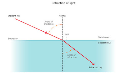
Rayleigh scattering of the sun's rays occurs when sunlight strikes air molecules. Higher frequencies of light (green, blue, violet) are more readily scattered than lower ones (red, orange, yellow) so when we look at the sky away from the Sun, most of what we see is scattered blue light. The interaction of sunlight with much larger water droplets is categorically different. Instead of scattering, light traveling from air to water (or for that matter, across the boundary of any two different media) is refracted.
This means that the angle of the light ray to the normal (the perpendicular to the boundary between media) changes as it passes from one to another. The origin of this effect is the fact that light travels at different speeds through different media. The extent to which this occurs for different substances is measured by a medium's index of refraction, often denoted n. If two media have indices of refraction n1 and n2 then the angles of the light rays to the normal within each (denoted θ1 and θ2) are given by Snell's Law:
n1sinθ1 = n2sinθ2
For air and water, the indices take values nair = 1.000293 and nwater = 1.330. Snell's Law then yields the fact that light rays bend toward the normal as they pass from air to water and do the opposite upon exiting. However, these values of the indices of refraction are for a specific wavelength of light (actually a standard color of yellow light emitted from excited atoms of sodium with a wavelength of 589.3 nm). The degree of refraction varies slightly across the visible wavelengths, leading to the separation of colors that we observe as a rainbow. The small droplets of water in the atmosphere are roughly spheres, leading to the kind of refraction illustrated below:
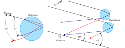
Note that the angles by which the light rays are refracted depends on where it hits the drop (the redness of the lines has no significance in this image) since the boundary between water and air is spherical, rather than flat. Each of the rays shown undergoes a single internal reflection before emerging from the water droplet, though some light just passes through, and some is internally reflected multiple times (more on this later). However, the maximum angle between the incoming and outgoing rays are different for different colors of light: in particular, they are greater for longer wavelengths than shorter. Therefore, at the very highest angles, the colors are separated.
At one end of the spectrum, violet light has a maximum angle of 40° from the incoming light ray, while in the longest visible wavelengths, red light has a maximum angle of 42° (left). As a result, for a fixed observer, red light will appear to come from a certain angle in the sky, while violet will appear to come from another (right). Orange, yellow, green, blue, and indigo will appear in between. The result is what we see as a rainbow.
Several properties of rainbows follow directly from this understanding. The first is that all (primary) rainbows are of the same angular size in the sky, namely 42° in radius. A rainbow therefore does not have a fixed position and appears the same size to every observer, meaning that every observer in fact sees their own rainbow. Also, the center of the rainbow's circular arc must be opposite to the position of the Sun in the sky. This point is called the anti-solar point and must always be below the horizon (since the Sun is above). As a result, the higher the Sun is in the sky, the lower the (primary rainbow). If the Sun is more than 42° above the horizon, it cannot be seen at all. This is why rainbows are typically seen early in the morning or later in the afternoon. In addition, though the maximum angle is 40-42° for different colors of light, some light (of all colors) is reflected from raindrops at smaller angles, making the sky just inside the rainbow noticeably brighter. This effect is apparent in the image above.
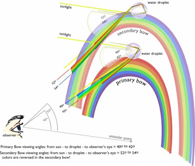
Though most light reflected within the raindrop undergoes only a single internal reflection, some is in fact reflected more than once, leading to what are known as higher-order rainbows, notably the secondary rainbow.
The colors of the secondary rainbow are reversed since an additional reflection inside the drop reverses the color spread. Further, it is situated at 52°, outside the primary rainbow, and is considerably fainter.
The secondary rainbow is sometimes too faint to be visible, but it is always there. In fact, light can reflect internally even more, producing higher-order rainbows. However, three reflections sends the light on a path at about 43° inclined from its original trajectory, meaning that it would form a circle of this radius around the Sun. Due to its faintness and proximity to the Sun, it is very difficult to photograph, but photographs have recently captured this phenomenon (see below).
Thus, a simple application of atmospheric optics may explain the rainbow, the beauty of which has captivated humanity since antiquity.
Sources: http://www.atoptics.co.uk/rainbows/primary.htm, http://www.physicsclassroom.com/class/refrn/Lesson-4/Rainbow-Formation, http://0.tqn.com/d/weather/1/S/j/T/-/-/water-drop-prism-lrg_nasascijinks.png, http://ephy.in/wp-content/uploads/2014/11/clip_image0061.png, http://www.nilvalls.com/supernumerary-rainbow/, http://www.atoptics.co.uk/rainbows/ord34.htm
Labels:
Meteorology
Wednesday, April 15, 2015
Annular Tropical Cyclones
An annular tropical cyclone is a tropical cyclone (various types of which are hurricane, typhoon, tropical storm, or simply cyclone, depending on location and intensity) with certain distinguishing structural characteristics. These characteristics not only affect the appearance of the tropical cyclone but also its evolution and interaction with the surrounding environment.
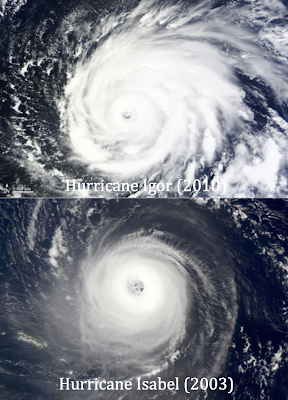
The word "annular", meaning "ring-shaped", describes the shape of this type of system. The image below demonstrates the visual differences between ordinary and annular tropical cyclones.
The top image shows a "normal" tropical cyclone, Hurricane Igor of 2010. The bottom image is Hurricane Isabel of 2003, during an annular stage. Though the cyclones were of comparable intensities, they differ greatly in structure. A typical powerful tropical cyclone will have a relatively small eye and spiral rain bands emanating far from the center of circulation. Annular tropical cyclones, on the other hand, have large, symmetric eye features, and are almost perfectly circular. In addition, they tend to be smaller and more compact than other cyclones (the images above are not to the same scale).
Annular tropical cyclones were not recognized as a distinct category until 2002, at which time the concept was introduced in a paper (see here). This idea was created in an effort to explain a class of cyclones which not had a different appearance but also had a notorious tendency to defy prediction, especially intensity forecasting.
In an effort to objectively define whether a given tropical cyclone is annular, researchers developed an algorithm to measure the characteristics of annular tropical cyclones. Using satellite data to measure cloud heights, eye radii, and the like, the algorithm takes a satellite image of a cyclone and outputs a numerical value: the annular hurricane index. If this value is less than zero, the cyclone is non-annular, but if the value is greater than zero, it is annular.
Since the algorithmic method derives a numerical value from a still satellite image, it follows that the index may change with time, and thus that a single tropical cyclone may at one time be annular and at other times not. This reflects observational intuition: weak cyclones by their very nature do not have the symmetry and eye structures which factor into the annular hurricane index. Being annular is a phase of a tropical cyclone's evolution, not an inherent property of a cyclone, and cyclones can further be annular at different intensities and for different durations.
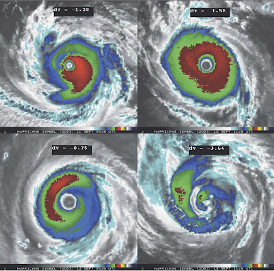
The above image appears in the paper introducing the annular hurricane index (see here for the source). It shows several stages of evolution of a single hurricane, once again Hurricane Isabel of 2003. The different colors on the infrared images indicate various cloud top temperatures. The cooler a cloud top, the higher its altitude, and (roughly) the stronger the storm at that location. In the first image (from September 11), the strengthening category 4 Isabel still possesses visible banding features to the south and east and is notably asymmetric, resulting in a negative annular hurricane index. By the second image on September 12, Isabel was a category 5 hurricane, had lost all bands, and was close to circular in structure. With an index of 1.58, the cyclone met the criteria of an annular cyclone on this date. The third image, taken September 14, shows the hurricane, still a category 5, with quite circular cloud coverage and still little banding. However, the distribution of the coldest cloud tops is asymmetric, resulting in a slightly negative index for this date. By September 18, the hurricane had weakened to a category 2, and some dry air had invaded the system. The spiral structure contributed to the index being far below zero for this date.
Annular tropical cyclones also intensify and weaken quite differently from typical cyclones. While on intensifying trends, typical hurricanes and typhoons will often fluctuate in intensity once they reach major hurricane wind speeds (111 mph and up). The cause of this phenomenon is called the eyewall replacement cycle.
An eyewall replacement cycle is a process during which the eyewall (the ring of strong thunderstorms surrounding the eye) of a cyclone contracts, dissipates, and is replaced by another. The image above, from the Hurricane Research Division of the NOAA, illustrates such a cycle in the evolution of Hurricane Wilma, the most intense Atlantic hurricane ever recorded. The top row shows a series of visible satellite pictures, the second row infrared images, and the bottom vertical cross-sections through the center of the hurricane, showing approximate cloud heights.
The first column illustrates Wilma's compact eye at the time of its record peak intensity on October 19. In the second column, taken October 20, a new ring of clouds, the secondary eyewall, has completely surrounded the first. When this occurs, the first eyewall loses access to moisture and weakens, causing the eye to visibly cloud over just as it does in the second column. With a less-defined center of circulation, the maximum winds decrease and the pressure rises (in this case, Wilma weakened from a category 5 to a category 4). By the third image (from October 21) the first eyewall has dissipated completely, and the secondary wall has become the new primary one, causing the intensity of Wilma to level out (at least temporarily).
However, annular cyclones generally do not experience eyewall replacement cycles, instead maintaining their characteristic large, circular eyes for days at a time. This property exemplifies a more general trend: annular cyclones respond less to changes in their environment than regular tropical cyclones. In particular, having reached their peak intensity, they, in the absence of very cold water or land interaction, tend to weaken only very slowly.
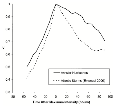
The above graph compares annular hurricanes (6 cases) and other Atlantic hurricanes (56 cases) that did not encounter especially hostile conditions (again, land and very cold water). The intensity trends of the cyclones were averaged and normalized, so that a v-value of 1 corresponds to the peak intensity of a cyclone. Notably, annular hurricanes strengthen slightly more slowly and weaken significantly more slowly than their ordinary counterparts. Examples include 2014's Hurricane Iselle in the Pacific, which maintained hurricane intensity over marginal sea surface temperatures much longer than expected by forecasters. Iselle ultimately made landfall in Hawaii as a tropical storm, a very rare occurrence.
Annular cyclones form a very distinct class of cyclones that exhibit abnormal behavior. Though we do not yet fully understand how and why these cyclones form and act as they do, we continue to make advances in their identification and prediction, including the development of the annular hurricane index. Further research will help us comprehend these cyclones and more adequately prepare for them.
Sources: http://journals.ametsoc.org/doi/pdf/10.1175/2007WAF2007031.1, http://rammb.cira.colostate.edu/resources/docs/annular_Knaff.pdf, http://earthobservatory.nasa.gov/IOTD/view.php?id=45780, http://en.wikipedia.org/wiki/Annular_tropical_cyclone, http://www.nhc.noaa.gov/archive/2014/ep09/ep092014.discus.013.shtml?, http://www.aoml.noaa.gov/hrd/tcfaq/D8.html
Labels:
Meteorology
Friday, January 9, 2015
Madden-Julian Oscillation
The Madden-Julian Oscillation (MJO) is a periodic fluctuation of convective activity in the tropics that impact the activity of the monsoon and the formation of tropical cyclones in various basins throughout the world.
Near the equator, weather is more chaotic and less structured than at midlatitudes. At midlatitudes, large cyclones and, sometimes, attached frontal boundaries, govern weather patterns. However, the formation of the vortices of these cyclones requires an effect called the Coriolis effect. The Coriolis effect, in essence, induces rotation in midlatitude regions because the rotation of the Earth carries points at different latitudes at different speeds. But at the equator and the area immediately around it, this effect is not significant enough to cause rotation under usual circumstances. Thus weather patterns in the tropics are rather caused by undulations of the Intertropical Convergence Zone (ITCZ), which seemed to produce shower and thunderstorm activity randomly.
However, some evidence contrary to the idea that the fluctuations were random has been known since antiquity. India's weather, for example, includes clearly demarcated dry and wet seasons in association with the monsoon, despite the fact that southern India's weather is predominantly affected by the activity of the ITCZ. In the 1970's, when more meteorological data became available, scientists Roland Madden and Paul Julian, after whom the oscillation is named, noted that there was a recurring cycle between increased precipitation and suppressed precipitation in the tropics, particularly notable in the Indian Ocean and the Pacific Ocean. More data emerged over the coming years, revealing that the anomalies in tropical precipitation tended to follow the equator, moving east around the globe over time.
The areas of increased and decreased thunderstorm activity associated with the MJO span several thousand miles; in areas of increased activity, the MJO is said to be in positive phase, and in areas of suppressed activity, in negative phase. Each "phase" propagates eastward around the globe at 4-8 meters per second, and therefore takes 30-60 days to travel around the Earth. This time interval, though not an exact value, is the period of the MJO, or in other words, the time necessary for the precipitation anomalies to return to roughly their initial conditions. At any given time, there are about 1-2 areas of increased convection and 1-2 areas of decreased convection that span the tropics.
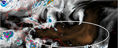
The above water vapor imagery from the NOAA shows a dry air mass over much of the central Atlantic and Caribbean. The increased tendency for dry air masses to appear in an area of the tropics is thought to correlate with the negative phase of the MJO.
The MJO, as well as governing the onset of the monsoon in India and other locations, can also have an effect on tropical development, even in the Atlantic and Pacific basins. Dry air is often devastating to tropical cyclones, invading their circulations and weakening or even dissipating them. Though some parts of the typical Atlantic and Pacific hurricane seasons are more active then others, in any particular season, the tropical cyclone activity may modulate with the MJO, increasing during positive phase and decreasing in negative phase. In support of this theory, it is a well documented fact that the Atlantic basin tends to be quiet when the Eastern Pacific basin is active and vice versa. This is because these neighboring basins tend to be experiencing opposite phases of the MJO at any given time.
The study and modeling of the MJO is very important to meteorology becuase this oscillation brings order to the chaos of tropical weather. Greater understanding of the MJO will aid long-term and large-scale forecasts, and improve our ability to antipicate tropical cyclonogenesis.
Sources: http://www-das.uwyo.edu/~geerts/cwx/notes/chap12/mjo.html, http://maddenjulianconversation.blogspot.com/2011/08/what-is-mjo-part-1.html, http://www.met.reading.ac.uk/~pete/mjo.html, http://en.wikipedia.org/wiki/Madden%E2%80%93Julian_oscillation, https://www2.ucar.edu/sites/default/files/news/2011/MJO_illus.jpg
Labels:
Hurricane Stats,
Meteorology
Thursday, January 1, 2015
Derechos
Derechos are a meteorological phenomenon consisting of long lines of heavy thunderstorms persisting for several hours and traveling a large distance. Unlike typical pop-up thunderstorms which are usually localized, derechos bring all the threats of severe thunderstorms—heavy rainfall, hail, high winds, and possibly tornadoes—to large swaths of land. Thus derechos can be particularly damaging to life and property.
The word "derecho" is Spanish for "straight", and this name reflects the nature of the wind damage associated with the storms. For reasons discussed below, derechos cause "straight-line wind damage". For a thunderstorm complex to be a derecho, the complex must cause severe wind gusts (where "severe" refers to winds in excess of 50 kt or 58 mph) along a swath of land extending at least 250 miles in length.
The conditions that spawn derechos often involve the collision of moist tropical air and cool air from the polar regions, often along a cold frontal boundary. The warm, unstable nature of the tropical air causes it to rise near the border of the two air masses as the cold air slides beneath it. This process forms cumulonimbus clouds, very large clouds that can stretch from the lower atmosphere to over ten miles high. Such clouds are characteristic of thunderstorms, so storms tend to form along the frontal boundary, giving rise to a long ridge of clouds called a shelf cloud:
Another defining feature of derechos is the curvature the line of thunderstorms that develops as the system progresses. The curved radar signature left by these storms are called bow echoes, due to their likeness to archer's bows. This phenomenon is illustrated below by a composition of time-step radar images from a derecho on June 29, 2012.
Seven consecutive radar images are superimposed, showing the development of the bow echo. In addition, the image displays wind gusts observed at different locations during the progress of the derecho. Since several of these in fact were hurricane-strength gusts (exceeded 73 mph), and the storm traversed over 450 miles during its lifetime, this system does indeed meet the qualifications of a derecho.
As noted above, the hallmark of a derecho is straight-line wind damage. The sources for such winds is the downburst, a phenomenon in which cool air descends quickly to ground level and spreads in all directions, sometimes causing extremely high winds. Downbursts occur when a large air mass is rapidly cooled by the evaporation of water, the sublimation of ice directly into vapor, or the melting of ice crystals. Since all of these processes are endothermic, or require energy from the surrounding environment, they cause the air in the vicinity to cool. The mass of air, having been cooled, is now heavier than the surrounding air and accelerates toward ground level. When it reaches the ground, it is forced outward in all directions, causing winds spreading uniformly from the impact point, hence the straight-line winds.
Within a downburst, which may span distances of several tens of miles, there are sometimes smaller-scale features known as microbursts, which are a few miles in length and contain especially intense winds. On a yet smaller scale are the burst swaths that sometimes occur in microbursts, areas of just thousands of square feet in which the wind speeds may rival those of a tornado. The straight-line winds of a derecho are also responsible for the bow echoes that appear on radar. Winds emanating from near the center of the squall line fan out and cause its edges to bend into the bow shape.
Meteorologists and climatologists, using data from the past 30 years, have analyzed how often and where derechos occur, predominantly within the United States.
The above map shows the frequency of derechos in different areas of the United States. Virtually no derechos have occurred in the west, and the most active area for derechos is the southeastern plains, which periodically have multiple derechos in a single year. Note also that these storms are most common in the area stretching from Minnesota to western Ohio during the warm season, and in an area from eastern Texas through the southern Gulf states during the colder months. It is likely that derechos occur regularly outside the United States, but very few thunderstorm events have been formally classified as such.
Sources: http://spanish.about.com/od/spanishvocabulary/a/derecho.htm, http://en.wikipedia.org/wiki/Derecho, http://www.spc.noaa.gov/misc/AbtDerechos/images/HampshireIL2008July10.gif, http://www.theweatherprediction.com/habyhints/288/, http://www.xweather.org/derecho, http://www.spc.noaa.gov/misc/AbtDerechos/bowechoprot.htm, http://www.crh.noaa.gov/iwx/?n=june_29_derecho, http://www.radiotimeline.com/wx-downburst.gif, http://www.spc.noaa.gov/misc/AbtDerechos/climatologypage.htm
The word "derecho" is Spanish for "straight", and this name reflects the nature of the wind damage associated with the storms. For reasons discussed below, derechos cause "straight-line wind damage". For a thunderstorm complex to be a derecho, the complex must cause severe wind gusts (where "severe" refers to winds in excess of 50 kt or 58 mph) along a swath of land extending at least 250 miles in length.
The conditions that spawn derechos often involve the collision of moist tropical air and cool air from the polar regions, often along a cold frontal boundary. The warm, unstable nature of the tropical air causes it to rise near the border of the two air masses as the cold air slides beneath it. This process forms cumulonimbus clouds, very large clouds that can stretch from the lower atmosphere to over ten miles high. Such clouds are characteristic of thunderstorms, so storms tend to form along the frontal boundary, giving rise to a long ridge of clouds called a shelf cloud:
| A shelf cloud, representing the leading edge of a line of thunderstorms |
Another defining feature of derechos is the curvature the line of thunderstorms that develops as the system progresses. The curved radar signature left by these storms are called bow echoes, due to their likeness to archer's bows. This phenomenon is illustrated below by a composition of time-step radar images from a derecho on June 29, 2012.
Seven consecutive radar images are superimposed, showing the development of the bow echo. In addition, the image displays wind gusts observed at different locations during the progress of the derecho. Since several of these in fact were hurricane-strength gusts (exceeded 73 mph), and the storm traversed over 450 miles during its lifetime, this system does indeed meet the qualifications of a derecho.
As noted above, the hallmark of a derecho is straight-line wind damage. The sources for such winds is the downburst, a phenomenon in which cool air descends quickly to ground level and spreads in all directions, sometimes causing extremely high winds. Downbursts occur when a large air mass is rapidly cooled by the evaporation of water, the sublimation of ice directly into vapor, or the melting of ice crystals. Since all of these processes are endothermic, or require energy from the surrounding environment, they cause the air in the vicinity to cool. The mass of air, having been cooled, is now heavier than the surrounding air and accelerates toward ground level. When it reaches the ground, it is forced outward in all directions, causing winds spreading uniformly from the impact point, hence the straight-line winds.
| The life cycle of a downburst |
Within a downburst, which may span distances of several tens of miles, there are sometimes smaller-scale features known as microbursts, which are a few miles in length and contain especially intense winds. On a yet smaller scale are the burst swaths that sometimes occur in microbursts, areas of just thousands of square feet in which the wind speeds may rival those of a tornado. The straight-line winds of a derecho are also responsible for the bow echoes that appear on radar. Winds emanating from near the center of the squall line fan out and cause its edges to bend into the bow shape.
Meteorologists and climatologists, using data from the past 30 years, have analyzed how often and where derechos occur, predominantly within the United States.
The above map shows the frequency of derechos in different areas of the United States. Virtually no derechos have occurred in the west, and the most active area for derechos is the southeastern plains, which periodically have multiple derechos in a single year. Note also that these storms are most common in the area stretching from Minnesota to western Ohio during the warm season, and in an area from eastern Texas through the southern Gulf states during the colder months. It is likely that derechos occur regularly outside the United States, but very few thunderstorm events have been formally classified as such.
Sources: http://spanish.about.com/od/spanishvocabulary/a/derecho.htm, http://en.wikipedia.org/wiki/Derecho, http://www.spc.noaa.gov/misc/AbtDerechos/images/HampshireIL2008July10.gif, http://www.theweatherprediction.com/habyhints/288/, http://www.xweather.org/derecho, http://www.spc.noaa.gov/misc/AbtDerechos/bowechoprot.htm, http://www.crh.noaa.gov/iwx/?n=june_29_derecho, http://www.radiotimeline.com/wx-downburst.gif, http://www.spc.noaa.gov/misc/AbtDerechos/climatologypage.htm
Labels:
Meteorology
Friday, January 17, 2014
Milankovitch Cycles 3
This is the third part of a series on the celestial cycles that periodically influence Earth's climate. For the first part, see here. For the second, see here.
In the first two parts of this post, two types of precession and their combined effect on the Earth's climate were explored. However, the Earth's orbit, as well as rotating over time, also varies in eccentricity. Currently, the eccentricity of Earth's orbit is about 0.017. However, due to slight perturbations from the other planets, the elongation of the ellipse that is Earth's orbit changes over time, going as low as 0.005 (nearly a perfect circle) and as high as 0.058. The mean value of the cycle is 0.028.
Unlike the variations discussed thus far, eccentricity variation does not have a simple cycle, but is rather a sum of component cycles, with all of the planets adding a contribution, some greater than others. Since these components are of different periods, simply evaluating the period by multiplying yields an exact period longer than the age of the Solar System. Thus one must use an "approximate" period that yields a cyclic variation, but within a certain error margin. Such a approximation yields a period of about 100,000 years, but with error margins that vary considerably.
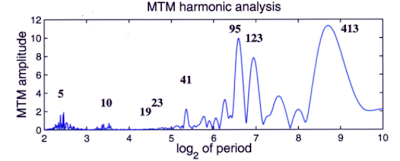
The above diagram is an analysis of the periods of the eccentricity variations in the Earth's orbit. The x-axis has lengths of periods in thousands of years, organized logarithmically. For example, the value of 3 on the x-axis corresponds to a period of 23*1000 = 8000 years. The y-axis indicates "how closely" the eccentricity variation has a component with a period of a given length. For example, as indicated, there is a peak in the curve labeled "413", meaning that it occurs at 413,000 years. The peak indicates that there is a significant component of the variation with a period of this length.
Overall, the eccentricity variation has the effect of accentuating or dampening the effects of axial and apsidal precession. Before we delve into the climatological effects more fully, one more variation must be considered: axial tilt variation.
In addition, to the Earth's axis precessing in a circular motion, the obliquity of the axis, or the angle between the line through the center of the Earth perpendicular to the plane of the Earth's orbit and the line of the Earth's poles, changes in an approximately periodic manner. This process is also called nutation.
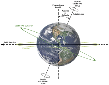
A diagram illustrating the obliquity of the Earth's axis. However, the tilt shown in the figure, which is currently about 23.4°, is not constant. It too changes with time, with a period of about 41,000 years, varying from 22.1° to 24.5° over its cycle.

The image shows the highest and lowest obliquities that Earth's axis experiences during its cycle. The current obliquity is near the midpoint of the two end values and is decreasing towards 22.1°. However, the amplitude of the variation of the obliquity over its period is not constant. The high and low values shown in the above diagram represent the most extreme variation, but some 41,000 year periods have seen variation of less than half a degree.
The Moon, which exerts gravitational forces on the Earth, acts to stabilize the variation in the position of the Earth's axis. It has been estimated that, without the Moon, the Earth's obliquity could vary enormously, on the scale of tens of degrees over its period. The influence that the Moon has on stabilizing the Earth's axis is quite important in keeping climate patterns stable. Without it, the Earth's climate could vary chaotically, with formerly polar regions becoming tropical and vice versa within tens of thousands of years which, though still a long period, would be devastating to delicate ecosystems and biodiversity.
Both of these variations have great effects on climate, the most significant of which are the amplitudes of seasonal variation. Near the highest eccentricity over the period of variation in its orbit, the Earth receives over 20% more sunlight (per unit area) at perihelion than aphelion. Due to the dampening effect of the insulation of Earth's atmosphere, the planet's heat content does not vary to this degree. However, seasonal variation would increase significantly, making these phases of the eccentricity cycle more susceptible to ice ages, as is reflected in paleoclimatological records.
Thus far, we have been treating the properties of the orbit of the Earth and all its effects on climate as if it were lying exactly in the plane of the Solar System. However, the orbit is also inclined from the plane, and this inclination varies. Before discussing the climatological effects of this variance, we must pin down precisely what the "plane of the Solar System" is.
On Earth, we typically consider the positions of bodies in the sky relative to the plane of the ecliptic, which is the plane of Earth's orbit (the ecliptic itself is the "intersection" of this plane with the celestial sphere). However, abandoning this geocentric view, we consider what is called the invariable plane. To find the invariable plane, one must find the barycenter, or center of mass, of the Solar System. The Solar System as a whole (neglecting any internal interactions) behaves as if it is a single object with a mass equivalent to that of the Solar System at its barycenter. The average rotational properties of all bodies of the Solar System provide the angular momentum vector for this ersatz representation of the system, and the invariable plane is defined as the plane passing through the barycenter perpendicular to this vector.
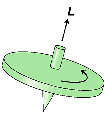
The angular momentum vector for an object is perpendicular to the plane of rotation, as in the top above, where L is the direction of the vector. Similarly, the angular momentum of the imaginary object representing the Solar System is perpendicular to its (again imaginary) plane of rotation.
The Sun, being on top of the center of gravity of the Solar System, does not contribute significantly to its overall angular momentum. The biggest contributions come from the gas giants, particularly Jupiter. The angle between the plane of Earth's orbit and this invariable plane is about 1.57°, which varies with a period of about 100,000 years. The places where the Earth's orbit crosses the invariable plane "going up" and "going down" are called the ascending node and descending node, respectively, and these presently occur on July 9 and January 9, respectively. Note that these nodes can be defined with respect to any plane, but we are taking it to be the invariable plane in this instance.
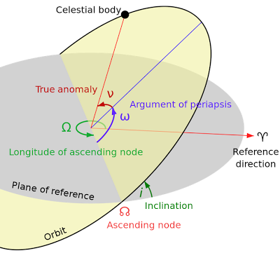
The above figure is a summary of some other orbital parameters of a celestial body, including the ascending and descending nodes and their longitudes, i.e., their angle from a reference direction in the invariable plane. The inclination of Earth's orbit and the position of these nodes have subtle and varied effects on climate; the positions of the nodes effect where the Earth passes through meteor showers. These, in turn, create atmospheric dust, especially in the polar regions, that form high-altitude clouds, as water vapor clings to the dust particles. These clouds are called noctilucent clouds, and a possible correlation between their abundance and ice ages has been observed in geologic records.
Milankovitch cycles help to explain at least some of the cycles of cooling and warming that the Earth experiences. However, some important disclaimers must be made. First, some feedback mechanisms help to accentuate or dampen any climatological changes brought about by orbital or rotational properties. For example, in a warming period, the polar ice caps shrink, releasing some trapped carbon dioxide that causes further warming. Therefore, even changes that are started by the Milankovitch cycles cannot be solely attributed to the cosmos, as they are but the beginning of a chain reaction here on Earth.
Second, there are many climage changes that cannot be explained through Milankovitch cycles. Large meteoroid impacts, volcanic eruptions, and other Earth-based phenomena could change or even counteract any effect of the orbit on Earth's climate, and often work in much shorter time periods.
Despite these shortcomings, the Milankovitch cycles have explained much about past climate variation on Earth, and may play a significant role in the future. The complicated web of cause and effect between the cycles and various periods of Earth's geologic history is not yet fully elucidated, but many significant correlations have been observed that promise to help us understand our planet's history.
Sources: Milankovitch Cycles on Wikipedia, http://www.clim-past-discuss.net/2/519/2006/cpd-2-519-2006.pdf,http://bugle.imcce.fr/fr/presentation/equipes/ASD/person/Laskar/misc_files/Laskar_Robutel_1993.pdf
In the first two parts of this post, two types of precession and their combined effect on the Earth's climate were explored. However, the Earth's orbit, as well as rotating over time, also varies in eccentricity. Currently, the eccentricity of Earth's orbit is about 0.017. However, due to slight perturbations from the other planets, the elongation of the ellipse that is Earth's orbit changes over time, going as low as 0.005 (nearly a perfect circle) and as high as 0.058. The mean value of the cycle is 0.028.
Unlike the variations discussed thus far, eccentricity variation does not have a simple cycle, but is rather a sum of component cycles, with all of the planets adding a contribution, some greater than others. Since these components are of different periods, simply evaluating the period by multiplying yields an exact period longer than the age of the Solar System. Thus one must use an "approximate" period that yields a cyclic variation, but within a certain error margin. Such a approximation yields a period of about 100,000 years, but with error margins that vary considerably.

The above diagram is an analysis of the periods of the eccentricity variations in the Earth's orbit. The x-axis has lengths of periods in thousands of years, organized logarithmically. For example, the value of 3 on the x-axis corresponds to a period of 23*1000 = 8000 years. The y-axis indicates "how closely" the eccentricity variation has a component with a period of a given length. For example, as indicated, there is a peak in the curve labeled "413", meaning that it occurs at 413,000 years. The peak indicates that there is a significant component of the variation with a period of this length.
Overall, the eccentricity variation has the effect of accentuating or dampening the effects of axial and apsidal precession. Before we delve into the climatological effects more fully, one more variation must be considered: axial tilt variation.
In addition, to the Earth's axis precessing in a circular motion, the obliquity of the axis, or the angle between the line through the center of the Earth perpendicular to the plane of the Earth's orbit and the line of the Earth's poles, changes in an approximately periodic manner. This process is also called nutation.

A diagram illustrating the obliquity of the Earth's axis. However, the tilt shown in the figure, which is currently about 23.4°, is not constant. It too changes with time, with a period of about 41,000 years, varying from 22.1° to 24.5° over its cycle.

The image shows the highest and lowest obliquities that Earth's axis experiences during its cycle. The current obliquity is near the midpoint of the two end values and is decreasing towards 22.1°. However, the amplitude of the variation of the obliquity over its period is not constant. The high and low values shown in the above diagram represent the most extreme variation, but some 41,000 year periods have seen variation of less than half a degree.
The Moon, which exerts gravitational forces on the Earth, acts to stabilize the variation in the position of the Earth's axis. It has been estimated that, without the Moon, the Earth's obliquity could vary enormously, on the scale of tens of degrees over its period. The influence that the Moon has on stabilizing the Earth's axis is quite important in keeping climate patterns stable. Without it, the Earth's climate could vary chaotically, with formerly polar regions becoming tropical and vice versa within tens of thousands of years which, though still a long period, would be devastating to delicate ecosystems and biodiversity.
Both of these variations have great effects on climate, the most significant of which are the amplitudes of seasonal variation. Near the highest eccentricity over the period of variation in its orbit, the Earth receives over 20% more sunlight (per unit area) at perihelion than aphelion. Due to the dampening effect of the insulation of Earth's atmosphere, the planet's heat content does not vary to this degree. However, seasonal variation would increase significantly, making these phases of the eccentricity cycle more susceptible to ice ages, as is reflected in paleoclimatological records.
Thus far, we have been treating the properties of the orbit of the Earth and all its effects on climate as if it were lying exactly in the plane of the Solar System. However, the orbit is also inclined from the plane, and this inclination varies. Before discussing the climatological effects of this variance, we must pin down precisely what the "plane of the Solar System" is.
On Earth, we typically consider the positions of bodies in the sky relative to the plane of the ecliptic, which is the plane of Earth's orbit (the ecliptic itself is the "intersection" of this plane with the celestial sphere). However, abandoning this geocentric view, we consider what is called the invariable plane. To find the invariable plane, one must find the barycenter, or center of mass, of the Solar System. The Solar System as a whole (neglecting any internal interactions) behaves as if it is a single object with a mass equivalent to that of the Solar System at its barycenter. The average rotational properties of all bodies of the Solar System provide the angular momentum vector for this ersatz representation of the system, and the invariable plane is defined as the plane passing through the barycenter perpendicular to this vector.

The angular momentum vector for an object is perpendicular to the plane of rotation, as in the top above, where L is the direction of the vector. Similarly, the angular momentum of the imaginary object representing the Solar System is perpendicular to its (again imaginary) plane of rotation.
The Sun, being on top of the center of gravity of the Solar System, does not contribute significantly to its overall angular momentum. The biggest contributions come from the gas giants, particularly Jupiter. The angle between the plane of Earth's orbit and this invariable plane is about 1.57°, which varies with a period of about 100,000 years. The places where the Earth's orbit crosses the invariable plane "going up" and "going down" are called the ascending node and descending node, respectively, and these presently occur on July 9 and January 9, respectively. Note that these nodes can be defined with respect to any plane, but we are taking it to be the invariable plane in this instance.

The above figure is a summary of some other orbital parameters of a celestial body, including the ascending and descending nodes and their longitudes, i.e., their angle from a reference direction in the invariable plane. The inclination of Earth's orbit and the position of these nodes have subtle and varied effects on climate; the positions of the nodes effect where the Earth passes through meteor showers. These, in turn, create atmospheric dust, especially in the polar regions, that form high-altitude clouds, as water vapor clings to the dust particles. These clouds are called noctilucent clouds, and a possible correlation between their abundance and ice ages has been observed in geologic records.
Milankovitch cycles help to explain at least some of the cycles of cooling and warming that the Earth experiences. However, some important disclaimers must be made. First, some feedback mechanisms help to accentuate or dampen any climatological changes brought about by orbital or rotational properties. For example, in a warming period, the polar ice caps shrink, releasing some trapped carbon dioxide that causes further warming. Therefore, even changes that are started by the Milankovitch cycles cannot be solely attributed to the cosmos, as they are but the beginning of a chain reaction here on Earth.
Second, there are many climage changes that cannot be explained through Milankovitch cycles. Large meteoroid impacts, volcanic eruptions, and other Earth-based phenomena could change or even counteract any effect of the orbit on Earth's climate, and often work in much shorter time periods.
Despite these shortcomings, the Milankovitch cycles have explained much about past climate variation on Earth, and may play a significant role in the future. The complicated web of cause and effect between the cycles and various periods of Earth's geologic history is not yet fully elucidated, but many significant correlations have been observed that promise to help us understand our planet's history.
Sources: Milankovitch Cycles on Wikipedia, http://www.clim-past-discuss.net/2/519/2006/cpd-2-519-2006.pdf,http://bugle.imcce.fr/fr/presentation/equipes/ASD/person/Laskar/misc_files/Laskar_Robutel_1993.pdf
Thursday, January 9, 2014
Milankovitch Cycles 2
This is the second part of a series on the celestial cycles that periodically influence Earth's climate. For the first part, see here.
It was discussed in the last post that Earth's orbit, though very closely approximating a conic section, rotates over time with respect to its apsides, mainly due to the gas giants. However, another type of precession must also be considered: axial procession. This precession, rather than being involved with the orbit of the Earth, is concerned with its rotation.

The Earth revolves about an axis through its center, but this axis is not exactly perpendicular to the plane of the Earth and the Sun (see the figure above). Thus, at any given time, portions of the globe receive more sunlight than others over the course of a day. The hemisphere tilted away from the Sun and receiving less solar radiation is experiencing winter, and the hemisphere tilted toward the Sun and receiving more radiation is in summer. Over a complete revolution of the Earth around the Sun, different areas of the Earth are irradiated differently. The angle of the Earth's axis from the imaginary line through the center of the Earth perpendicular to the plane of the Solar system is 23.4°.
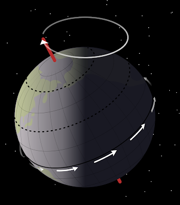
In the process of axial precession, the tilt of the axis does not change. The direction of the axis merely follows a circle (the white circle shown in the figure) with respect to the stars. A complete cycle of the axis takes 26,000 years. As this cycle occurs, the Earth's axis will point to different stars, so the "pole stars" will change over the period. For example, the closest fairly bright star to the celestial north pole (the position among the stars found by extending the Earth's axis into space) is currently Polaris, but over the 26,000 year period, the pole will drift, and become close to other stars, notably Vega and Deneb. Axial precession is caused by forces exerted by the Sun and Moon.
In addition to alterations of the appearance of the celestial sphere, axial precession also causes changes in climate. However, while apsidal precession changes the position of the apsides along the Earth's orbit, axial precession slowly shifts the position of the equinoxes along the orbit. To be more specific, the equinoxes move "backward" relative to the revolution of the Earth. This effect leads to some different definitions of the word "year". A sidereal year is the length of time it takes for the Earth to complete a orbit with respect to the stars, and is in many ways the "simplest" way to define a year. The length of the sidereal year is 365.256 days.
But this year is not that on which our calendar is based; our calendar is based on the tropical year, or the length of a complete cycle of seasons. This is loosely equal to the time from one equinox to the next. There is a slight subtlety here, though: the equinoxes do not shift at the same rate due to the eccentricity of the Earth's orbit. Due to the inequality of the lengths of the seasons, the vernal and autumnal equinox do not precess at the same rate. The equinox closer to perihelion "moves faster" than that near aphelion. Averaging the two rates gives the value used in calculating the tropical year. The tropical year is 365.2422 days, a slightly, but meaningfully different value than the sidereal year.
Thus the equinoxes and solstices will stay at approximately the same date on our (Gregorian) calendar, since this calendar is built around the tropical year using the following rules:
Returning to the effect of axial precession on the climate, it has an essentially the same effect as apsidal precession, in that both cause changes in the equinoxes relative to the Earth's orbit. These two types of precession essentially "add" yielding a period of 21,000 years. What this means is that, relative to the tropical year, which is measured by the equinoxes, the perihelion will return to the same position every 21,000 years. To obtain this figure, consider the time which it takes for an equinox to travel fully around Earth's orbit: 26,000 years. Since the tropical year is shorter than the sidereal year, the equinoxes move backward with respect to the Earth's orbit, i.e. opposite to its direction of motion. In this same time, however, perihelion will shift forward by a certain amount, reducing the time that must elapse before the two again coincide to 21,000 years. Therefore, in this time, the Northern hemisphere winter, initially coinciding with perihelion, will cycle completely, and once again coincide with perihelion at the end of the interval.
However, in addition to traveling through a cycle, the amplitude of the variations of the positions of the Earth's orbit and axis also vary, as we shall see in the next post.
Sources: Milankovitch Cycles, Axial Precession on Wikipedia
It was discussed in the last post that Earth's orbit, though very closely approximating a conic section, rotates over time with respect to its apsides, mainly due to the gas giants. However, another type of precession must also be considered: axial procession. This precession, rather than being involved with the orbit of the Earth, is concerned with its rotation.

The Earth revolves about an axis through its center, but this axis is not exactly perpendicular to the plane of the Earth and the Sun (see the figure above). Thus, at any given time, portions of the globe receive more sunlight than others over the course of a day. The hemisphere tilted away from the Sun and receiving less solar radiation is experiencing winter, and the hemisphere tilted toward the Sun and receiving more radiation is in summer. Over a complete revolution of the Earth around the Sun, different areas of the Earth are irradiated differently. The angle of the Earth's axis from the imaginary line through the center of the Earth perpendicular to the plane of the Solar system is 23.4°.

In the process of axial precession, the tilt of the axis does not change. The direction of the axis merely follows a circle (the white circle shown in the figure) with respect to the stars. A complete cycle of the axis takes 26,000 years. As this cycle occurs, the Earth's axis will point to different stars, so the "pole stars" will change over the period. For example, the closest fairly bright star to the celestial north pole (the position among the stars found by extending the Earth's axis into space) is currently Polaris, but over the 26,000 year period, the pole will drift, and become close to other stars, notably Vega and Deneb. Axial precession is caused by forces exerted by the Sun and Moon.
In addition to alterations of the appearance of the celestial sphere, axial precession also causes changes in climate. However, while apsidal precession changes the position of the apsides along the Earth's orbit, axial precession slowly shifts the position of the equinoxes along the orbit. To be more specific, the equinoxes move "backward" relative to the revolution of the Earth. This effect leads to some different definitions of the word "year". A sidereal year is the length of time it takes for the Earth to complete a orbit with respect to the stars, and is in many ways the "simplest" way to define a year. The length of the sidereal year is 365.256 days.
But this year is not that on which our calendar is based; our calendar is based on the tropical year, or the length of a complete cycle of seasons. This is loosely equal to the time from one equinox to the next. There is a slight subtlety here, though: the equinoxes do not shift at the same rate due to the eccentricity of the Earth's orbit. Due to the inequality of the lengths of the seasons, the vernal and autumnal equinox do not precess at the same rate. The equinox closer to perihelion "moves faster" than that near aphelion. Averaging the two rates gives the value used in calculating the tropical year. The tropical year is 365.2422 days, a slightly, but meaningfully different value than the sidereal year.
Thus the equinoxes and solstices will stay at approximately the same date on our (Gregorian) calendar, since this calendar is built around the tropical year using the following rules:
- A regular year is 365 days
- If the year is a number divisible by 4, it is a leap year, containing 366 days
- This makes the "average" year over a 4-year period equal to 365.25 days
- But if a year is divisible by 100, it is not a leap year
- Over the 100-year period 1900-1999, for example, there were 24 leap years: all years divisible by 4 except 1900
- This yields an "average" year of 365.24 days
- Finally, if the year number is divisible by 400 it is a leap year
- Over the 400-year period 1700-2099, for example, there are 97 leap years: 96 years divisible by 4 but not 100, three years, namely 1700, 1800, and 1900, that were not leap years, and one year, 2000, which by the above rule was a leap year
- These rules yield an "average" year over the 400-year period of 365.2425 days
Returning to the effect of axial precession on the climate, it has an essentially the same effect as apsidal precession, in that both cause changes in the equinoxes relative to the Earth's orbit. These two types of precession essentially "add" yielding a period of 21,000 years. What this means is that, relative to the tropical year, which is measured by the equinoxes, the perihelion will return to the same position every 21,000 years. To obtain this figure, consider the time which it takes for an equinox to travel fully around Earth's orbit: 26,000 years. Since the tropical year is shorter than the sidereal year, the equinoxes move backward with respect to the Earth's orbit, i.e. opposite to its direction of motion. In this same time, however, perihelion will shift forward by a certain amount, reducing the time that must elapse before the two again coincide to 21,000 years. Therefore, in this time, the Northern hemisphere winter, initially coinciding with perihelion, will cycle completely, and once again coincide with perihelion at the end of the interval.
However, in addition to traveling through a cycle, the amplitude of the variations of the positions of the Earth's orbit and axis also vary, as we shall see in the next post.
Sources: Milankovitch Cycles, Axial Precession on Wikipedia
Wednesday, January 1, 2014
Milankovitch Cycles
Milankovitch cycles, named after Milutin Milanković, a Serbian mathematician, are the periodic changes in the Earth's orbit and rotation that are the cause of gradual climate changes over periods of tens or hundreds of thousands of years. The composition of all the separate cycles involved yields a fairly complete long-term climactic picture.
In an idealized two-body problem, in which the Earth and the Sun are point masses isolated from the rest of the masses in the Universe, and assuming the orbiting body, the Earth, to be negligible in mass in comparison with the Sun, the bodies behave very predictably. The orbit of the less massive body is a conic section, with the Sun at one of the foci. "Conic section" is the general term for circles, ellipses, parabolas, and hyperbolas, each of which is depicted below.

All of the above conic sections share a focus (the dot at the center of the figure). For a circle, there is only one focus, and it is located at the center of the circle. For all other conic sections, two foci and a additional parameter (variable) determine them uniquely.
The defining property of a conic section, the one which determines its type, is a value known as eccentricity, denoted e. The parameter e is some nonnegative real number. If e = 0, the conic section is a circle. If it is between 0 and 1, the conic section is an ellipse, with the ellipse becoming more elongated as the eccentricity increases from 0 to 1. If e is exactly 1, then the curve is a parabola, and if e > 1, it is a hyperbola. Conic sections of eccentricity less than 1 represent orbits in which the orbiting object is trapped in the gravitational field of the larger object. Such orbits are periodic, and thus repeat after some amount of time. The others, of eccentricity 1 or greater, represent paths of objects in which the gravitational attraction of the larger mass is not enough to trap the smaller object, and it escapes.
These curves represent remarkably accurate approximations to planets' actual orbits, but are slightly different due to perturbations from other planets in their system. These perturbations often cause gradual changes in the shape or position of the orbit over time. We shall now focus our attention to the Earth's orbit.
The eccentricity of the Earth's orbit is about 0.0167, meaning that the orbit of the Earth is very nearly a circle, and only slightly elliptic. However, even this slight elongation causes the Earth to be closer to the Sun in some parts of its orbit than others. Earth's closest point to the Sun is called the perihelion (or periapsis) of the orbit, and the farthest point the aphelion (or apoapsis). These extreme points are called the apsides, and are always opposite one another about the focus.

In the case of the Earth, the difference between aphelion and perihelion is about 3 million miles, or 5 million kilometers, which is not too large relative to its average distance from the Sun of 93 million miles. Despite this, the eccentricity of the Earth's orbit greatly affects our climate. Currently, perihelion occurs during January and aphelion during July, as shown above (the eccentricity is exaggerated for emphasis). However, due to the gravitational influences of the other planets, particularly Jupiter and Saturn, the apsides precess about Earth's orbit. This cycle, called the cycle of apsidal precession, takes place relative to a fixed direction, called the reference direction.

The above figure illustrates apsidal procession, with both eccentricity and rate of precession exaggerated. If we treat the apsidal line of the first orbit (the horizontal line in the figure) as the reference direction, the angle (in the positive counterclockwise sense) that the apsidal line of each subsequent orbit (on the periapsal side) is what is called the angle of periapsis. Over a full cycle of apsidal procession, the angle of periapsis increases by 360°, i.e., the orbit returns to its former position. For the Earth, this cycle takes 112,000 years. This is one of the Milankovitch cycles, and it has a profound impact on our climate.
For the northern hemisphere, perihelion occurs during winter, and aphelion during summer. Since the Earth receives 6.8% more sunlight at perihelion (this figure comes from the fact that the light intensity dies off with squared distance; even though the distance of the Earth at aphelion is only 103.4% of that at perihelion, the light intensity differs by about 6.8%), our planet actually receives more sunlight in northern hemisphere winter than summer. However, the Earth's axial tilt, which we will consider later, dominates this relatively small effect. Currently, apsidal procession slightly dampens the seasonal variations in climate in the northern hemisphere, while accentuating them in the southern hemisphere.
If apsidal procession were the only cause of climactic variance, the state of the northern and southern hemispheres (with respect to the dampening or accentuating of seasonal variances) would reverse in 56,000 years, but apsidal precession is not the only effect on the seasons (see the next post).
One final interesting effect that the apsides have on our seasons is their lengths. The Earth travels slightly faster at perihelion, as it is closer to the Sun, so whatever season the Earth is experiencing at perihelion will be slightly shorter than the opposite season at aphelion, where the Earth is moving at its slowest relative to the Sun. Thus northern hemisphere winter (the time between the winter solstice and vernal equinox) is over four days shorter than summer. Through apsidal precession other seasons will become the longest over the 112,000 year time period.
Sources: Milankovitch Cycles on Wikipedia, http://www.jimloy.com/geometry/conic0.htm, http://huminities.blogspot.com/, http://www.answers.com/topic/why-are-the-lengths-of-the-seasons-not-equal
In an idealized two-body problem, in which the Earth and the Sun are point masses isolated from the rest of the masses in the Universe, and assuming the orbiting body, the Earth, to be negligible in mass in comparison with the Sun, the bodies behave very predictably. The orbit of the less massive body is a conic section, with the Sun at one of the foci. "Conic section" is the general term for circles, ellipses, parabolas, and hyperbolas, each of which is depicted below.

All of the above conic sections share a focus (the dot at the center of the figure). For a circle, there is only one focus, and it is located at the center of the circle. For all other conic sections, two foci and a additional parameter (variable) determine them uniquely.
The defining property of a conic section, the one which determines its type, is a value known as eccentricity, denoted e. The parameter e is some nonnegative real number. If e = 0, the conic section is a circle. If it is between 0 and 1, the conic section is an ellipse, with the ellipse becoming more elongated as the eccentricity increases from 0 to 1. If e is exactly 1, then the curve is a parabola, and if e > 1, it is a hyperbola. Conic sections of eccentricity less than 1 represent orbits in which the orbiting object is trapped in the gravitational field of the larger object. Such orbits are periodic, and thus repeat after some amount of time. The others, of eccentricity 1 or greater, represent paths of objects in which the gravitational attraction of the larger mass is not enough to trap the smaller object, and it escapes.
These curves represent remarkably accurate approximations to planets' actual orbits, but are slightly different due to perturbations from other planets in their system. These perturbations often cause gradual changes in the shape or position of the orbit over time. We shall now focus our attention to the Earth's orbit.
The eccentricity of the Earth's orbit is about 0.0167, meaning that the orbit of the Earth is very nearly a circle, and only slightly elliptic. However, even this slight elongation causes the Earth to be closer to the Sun in some parts of its orbit than others. Earth's closest point to the Sun is called the perihelion (or periapsis) of the orbit, and the farthest point the aphelion (or apoapsis). These extreme points are called the apsides, and are always opposite one another about the focus.

In the case of the Earth, the difference between aphelion and perihelion is about 3 million miles, or 5 million kilometers, which is not too large relative to its average distance from the Sun of 93 million miles. Despite this, the eccentricity of the Earth's orbit greatly affects our climate. Currently, perihelion occurs during January and aphelion during July, as shown above (the eccentricity is exaggerated for emphasis). However, due to the gravitational influences of the other planets, particularly Jupiter and Saturn, the apsides precess about Earth's orbit. This cycle, called the cycle of apsidal precession, takes place relative to a fixed direction, called the reference direction.

The above figure illustrates apsidal procession, with both eccentricity and rate of precession exaggerated. If we treat the apsidal line of the first orbit (the horizontal line in the figure) as the reference direction, the angle (in the positive counterclockwise sense) that the apsidal line of each subsequent orbit (on the periapsal side) is what is called the angle of periapsis. Over a full cycle of apsidal procession, the angle of periapsis increases by 360°, i.e., the orbit returns to its former position. For the Earth, this cycle takes 112,000 years. This is one of the Milankovitch cycles, and it has a profound impact on our climate.
For the northern hemisphere, perihelion occurs during winter, and aphelion during summer. Since the Earth receives 6.8% more sunlight at perihelion (this figure comes from the fact that the light intensity dies off with squared distance; even though the distance of the Earth at aphelion is only 103.4% of that at perihelion, the light intensity differs by about 6.8%), our planet actually receives more sunlight in northern hemisphere winter than summer. However, the Earth's axial tilt, which we will consider later, dominates this relatively small effect. Currently, apsidal procession slightly dampens the seasonal variations in climate in the northern hemisphere, while accentuating them in the southern hemisphere.
If apsidal procession were the only cause of climactic variance, the state of the northern and southern hemispheres (with respect to the dampening or accentuating of seasonal variances) would reverse in 56,000 years, but apsidal precession is not the only effect on the seasons (see the next post).
One final interesting effect that the apsides have on our seasons is their lengths. The Earth travels slightly faster at perihelion, as it is closer to the Sun, so whatever season the Earth is experiencing at perihelion will be slightly shorter than the opposite season at aphelion, where the Earth is moving at its slowest relative to the Sun. Thus northern hemisphere winter (the time between the winter solstice and vernal equinox) is over four days shorter than summer. Through apsidal precession other seasons will become the longest over the 112,000 year time period.
Sources: Milankovitch Cycles on Wikipedia, http://www.jimloy.com/geometry/conic0.htm, http://huminities.blogspot.com/, http://www.answers.com/topic/why-are-the-lengths-of-the-seasons-not-equal
Subscribe to:
Comments (Atom)

