The North of the Peak District – known at the Dark Peak – has a number of small inland cliffs or ‘Edges’. These facilitate great views over the interleaving valleys and are often punctuated with attractive rock formations formed from the local Gritstone left behind where softer shale layers have been eroded away.
The route I choose had a number of objectives:
- Link together as many named Edges as I could in a two day route.
- Allow me to try, for the first time, my complete set of ‘ultralight’ backpacking kit
- Using this ‘fast and light’ approach allowed for more miles per day (18 miles on day 2) – but with ease and comfort.
The Route

I chose the start and end points because they were connected by the railway. Because of the time it would take to drive to the start on day one, I split the distances unevenly (i) to allow for later start on the first day and (ii) because I’d seen photo’s of a great wild camping spot next to Back Tor. Because of the distance split and location of water sources, it made sense to do the walk East to West even though this meant initially driving to the end of the walk furthest from home.
Day 1 – Hathersage to Back Tor – 12.5 miles / 630 m height gain (HG)
After a very enjoyable drive over Snake Pass with the roof down, I arrived in Hathersage at 0945 and was walking by 1000. I had located two convenient places to park for 48 hours in the town, either in the railway station car park (only £2 / day and allowable for up to 7 days) or on Dore Lane.
An easily found footpath starts from near the railway station which steadily climbs, up through areas of woodland, to Hathersage Moor and then along the bottom of Burbage Rocks – my first Edge. The weather was glorious and there were many school groups out learning to climb up or abseil down these rocks. Stanage Edge was equally popular and more attractive still.


I stopped for lunch after around 7 miles and was now free of the crowds. The next 2 ½ miles was a necessary joining section to get me to Derwent Edge (Edge 3) but the sun was cracking the flags so it was simply lovely to be out and to have such a light pack on my back (6.5 kg base weight plus ≤1 kg of water). Once I had ascended onto Derwent Edge the scenic highlights came thick and fast in the form of a number of really attractive gritstone tors. Wheel Stones, White Tor, Salt Cellar, Cakes of Bread and then my destination for the night, Back Tor.


I found three attractive places to pitch around the base of Back Tor. The wind was light and many flies were around so I choose the most exposed pitch so the breeze would keep them away. I would still be in the lea of the Torr with the weather coming from the East and have a ringside position to see the sun set over Kinder Scout.


Having arrived at around 1530, I waited for a while before pitching my shelter. It was really lovely to sit on top of the Tor with my book and enjoy a dram of some orange infused Moonshine (whisky which is less than three years old) which I had helped design and made with one of my clients the previous Autumn. What could be a more apposite beverage on a fast and light weekend than dehydrated beer?
I enjoyed the sunset then drifted off to sleep. Rising and falling with the sun works really well for me.
A really positive feature of the Lofoten tent is being able to prop the door open as an awning, it would be too bold to say that this makes this micro shelter practical, but it does give the views you’d get from a tarp, with the wind protection of a tent and space to store you pack away from any dew or rain (so long as wind is not too strong).

Day 2 – Back Tor to Glossop – 18 miles / 500 m HG
I woke at 0530 to a glorious morning and was packed up and back on the trail just before 0700. My route initially took me downhill to the shore of the Derwent Reservoir where I collected water from a feeder stream, then it was back up to high ground again – this time Howden Edge. Reviewing the OSM map whilst writing this account I see that there are paths (albeit not formal footpaths) that could have taken me around the Abbey Brook ‘Clough’ without need to descend anywhere near as far. Worth noting. However given the prolonged dry period we had been enjoying would I have found water at the head of the brook?
Howden Edge was the least remarkable of the Edges on this walk, but it was not without it’s pleasures. More grit stone features and a great view to the, frankly very odd, Emley Moor Transmission Tower. This mast has the proud claim of being the tallest freestanding structure in the UK. Born in the same year as this author, it is now Grade II listed. I await my call from the Secretary of State for Culture…


The next high point, physically and metaphorically, was Bleaklow Stones were I enjoyed lunch in the lea of a rock which closely resembled a whales tale.

From this point it was mostly a ‘walk out’ with the final highlight being Dowstone Clough which marked the start of my winter wild walk to Kinder in 2023.

Then it was an easy stroll downhill into Glossop.
Getting back to the start – a useful lesson learned…
A major factor which defined this walk was the ability to return to my car using the train. However on the evening of the first day I thought I’d just check how much extra it would cost to get an Uber back rather than the train. The answer was just an an addition £2. (Suggesting that the either the rail fare was too high, or the Uber price too low – I suspect both to be true) In addition, because the train journey would involve heading into Manchester to get a second train back out to Hathersage, an Uber was a considerably faster option and one which allowed me to get home to my family in time for tea.
This hitherto unrealised option should open up many more linear walk options, since the cost difference between public transport and an Uber (for a 2-3 day walk) is so modest I / you do not need to be restricted to simply walk between places with a rail or bus connection; Termini served by Uber could offer yet further options.
My Fast & Light kit for this walk
(click through the links to see my more detailed review of each individual item)
- Tent – Nordisk Lofoten – more of a luxury hooped bivvy than a tent in reality.
- Pack – Atompacks Mo 50 (40 L would have been enough)
- Sleeping Bag – Rab Neutrino 200, 4 C comfort-rated bag.
- Sleeping Pad – Thermarest Prolite 3 (no longer available, nearest today is the ProLite Plus)
- Water system – Sawyer Squeeze paired with two HydraPak Stow flexible ‘bottles’.
* Pack weight (inc. everything except water) 6.5 kg.
Let me say that again, just 6.5 kg plus 1 kg of water! Coming from an era when we worked on the basis of aiming for pack-weights just shy of 1/3 of your own bodyweight (25 kg for me) this pack-weight is nothing short of amazing, especially when you consider that the only compromise I made was to use a micro tent. The Lofoten, with a real world weight of 600 g (once you’ve added practical pegs and a polycro footprint) and a ultra-low packed volume offers benefits well worth the price you pay in interior space for three season 2-3 day walks. I would be unlikely to take it away for a week of backpacking, but my two days walks significantly outnumber my longer trips.
The pack, new to me last autumn, was supremely comfortable and proved highly practical. I could have got all my kit into a 40 L pack, but I have the 50 L pack as it is very little heavier than the 40 L version and it means I can also use it for longer tips or in the winter.
My sleep system did not compromise comfort in any way. In the UK it is surprising for how much of the year the temperature does not drop below the 4 C comfort rating of my Rab bag. If I expect to experience a borderline temperature I simply opt for a winter sleeping pad, a pair of long johns and some down socks, the extra weight of which is less than the 200 g of going for the next warmest bag in the Neutrino range.

 Titanium cooking mug – I can both boil water in this and drink tea from it. If I take freeze dried or dehydrated (the former tends to be more tasty) food then my cooking mug never needs washing out because I eat out of the pouch. Thus I don’t carry any cleaning stuff either.


 Cheshire is dominated by flat agricultural plains and the petrochemical plants of Runcorn & Ellesmere Port and thus not the first place you think of as great walking country. Thus describing this as “the best walk in Cheshire” is something of a guarded compliment and rather underplays the views and drama of this ‘medium distance’ path. The route is defined by a sandstone ridge that elevates you above the plain thus affording you far reaching views, as far as the Clwydian Range of hills in North Wales in one direction and the Peak District in the other. But you don’t need to look into the far distance for interest, when you are on sections of the ridge the Sandstone itself is both colourful and very attractive


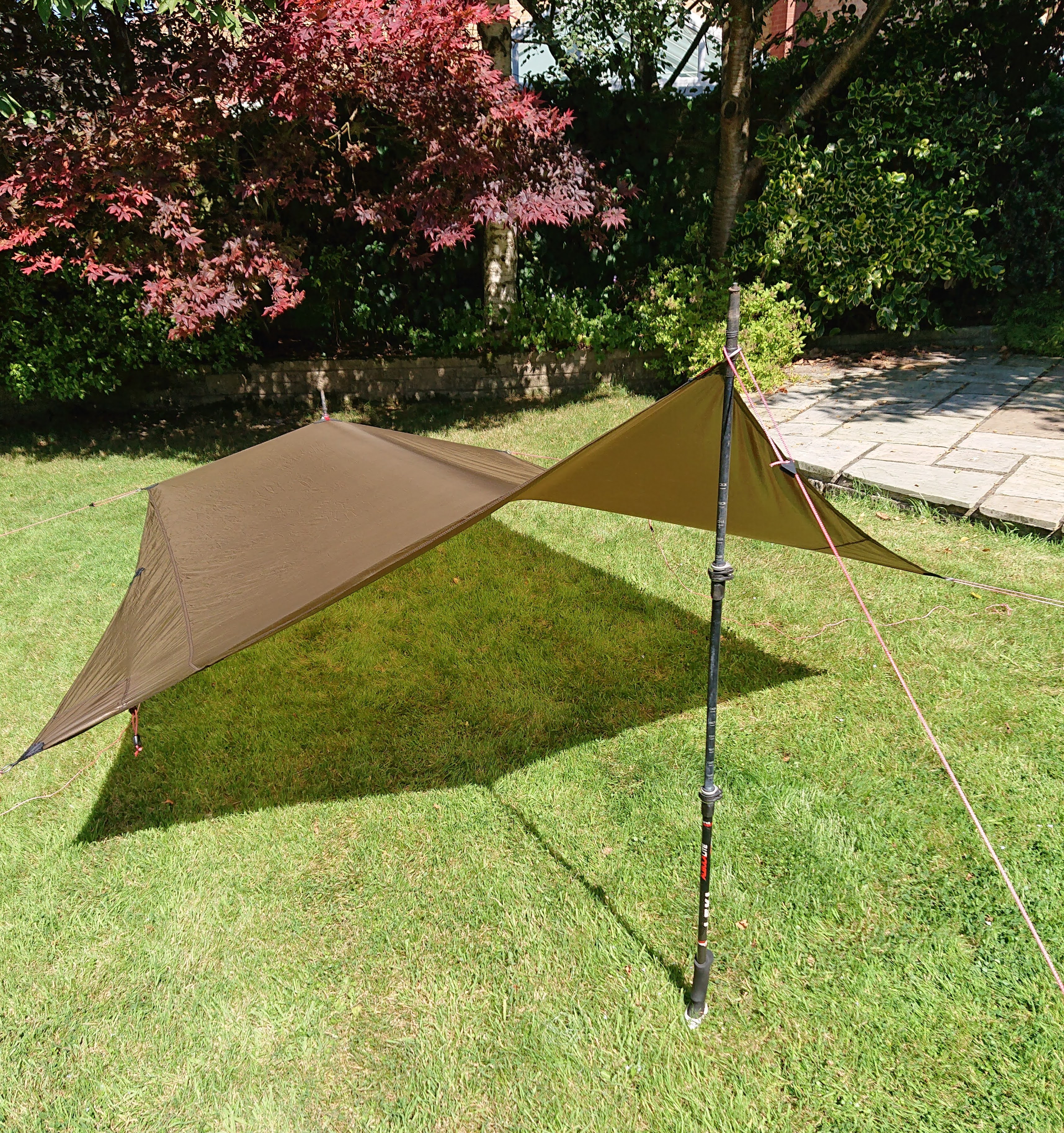
 A game changing feature of the Lofoten is being able to use the door as a tarp which gives you covered space to cook under, so long as the wind is not too strong (≤ 20-25 mph).