Cycling down the Danube – five days from Vienna to Budapest

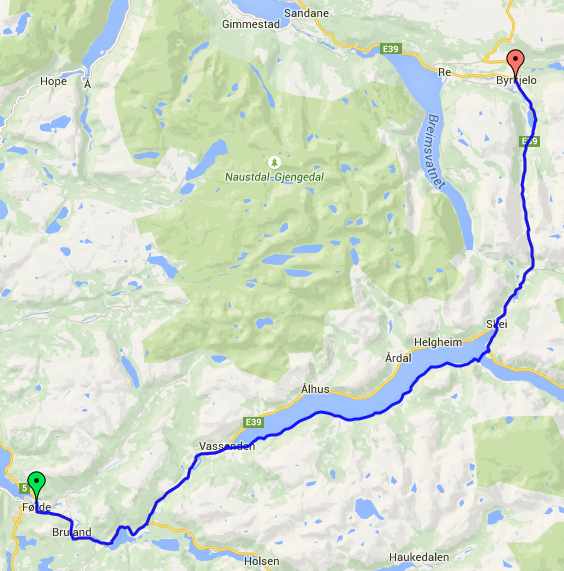
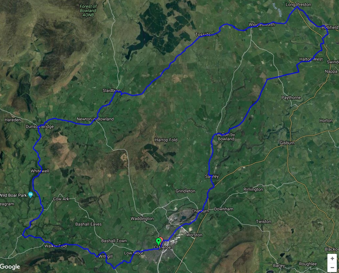
At 1770 miles in length, the Danube is the second-longest river in Europe. On its journey from the Black Forest in Germany to the Black Sea, it borders or passes through no less than nine different countries. Our 210-mile, five-day tour took us from Vienna to Budapest, passing through a stretch of Slovakia on the way. The two most popular sections of the Danube to cycle are this section and the earlier stretch from Passau to Vienna. It was Junior who inspired this tour with his request to ‘cycle tour for longer than my previous two-day rides, but on a route which must be flat.’ Thus, continental rivers and canals came to mind. I hoped he would also enjoy passing through three countries and three capital cities on the route.

We hired two bikes from Pedal Power in Vienna, and flew my Dawes Galaxy out with us as no one offered a hire bike which could take four panniers, and we needed all of this space (plus two panniers on Junior’s bike) to carry a family’s worth of camping and cycling gear. Pedal Power were excellent, really down to earth, helpful and non-bureaucratic. This set them apart from the other options we contacted. Mrs W had an e-bike to help protect a weak knee and this worked out really well, and again, to protect her knee, she was just carrying food for the day in hand.

Day 1 – Vienna to Hainburg an der Donau – 33 miles

The day started on the Micampa campsite next to the Danube and a stone’s throw from the Donaustadtbruke underground station. We had arrived the previous evening, and Mrs W cooked dinner whilst I extracted my bike from its bag and reassembled it. Early on day one, we stashed my bike travel bag in the campsite shop storeroom and, as I pedalled towards the centre of the city, the rest of the family set off on foot for the underground station. We arrived within minutes of each other at Pedal Power on Bösendorferstraße, where we picked up our pair of KTM hire bikes. We were very glad to have a pre-plotted route on my Garmin to thread our way back out of the city. Also good was the excellent cycle path network. On reaching the edge of town, we entered the Prater. Formerly a royal hunting park, it was given to the people by Emperor Joseph II in 1766. Today, this is a large green area of parkland, within which is an amusement park filled with vintage rides. When we returned to Vienna at the end of our trip, we took a ride on the 65-metre-tall Ferris wheel, itself built in 1897 and the world’s largest example until 1985.

Crossing the Danube to the North Bank was fun as a cycle lane had been retrofitted underneath the Praterbruke autobahn bridge. To join (and then exit) this involves cycling up (then down) a spiral ramp, something I’d never seen before. The second section of cycle path from the island to the far bank looked like the Rainbow Road track on Mario Kart which made Junior smile.

Mario’s Rainbow Road

We were now on the Eurovelo 6 cycle route and right next to the river for three miles. Adding interest, our route then took us through an OMV oil refinery. OMV had been one of the customers for the sulphur-removal absorbents whose manufacturing plant my team and I supported from 2007–2014.

The route then took us along a dyke across a broad plain. We were away from sight of the Danube for some while. We stopped on the outskirts of Orth an der Donau and one of us headed into the town to top up our water. We waited right next to a Pfizer manufacturing site whose primary product was the vaccine to protect against Tick-Borne Encephalitis, a jab we had all had to prepare for this trip! We passed through woods and fields on a perfect cycle path, only passing two villages before we were opposite Hainburg and heading next to a busy road for a bridge crossing to this Austrian town on the South Bank. The only campsite in Hainburg was closed until 1st May (a common date for many campsites to open along this route). We had thus needed to opt for a room in a hotel, itself a former monastery. The price for a family room was very reasonable and the quality of the hotel both excellent and a lot higher than I was expecting for the money. Formerly on the very edge of the Roman Empire, the town had very attractive fortified ‘gates’, like the those in York, and a castle.

Day 2 – Hainburg an der Donau to Vokja (Slovakia) – 32 miles

The start of day two had us cycling through a number of attractive small villages on the South Bank. After ten miles, we crossed the border into Slovakia and a further two miles brought us to the UFO bridge carrying road traffic into Bratislava. A typical example of Soviet architecture.

Just over a mile later, we reached our cyclist-friendly bridge and crossed into Bratislava. We didn’t stop to look at the city; instead, we stocked up on food for lunch and headed on, initially next to busy roads, and then around areas of abandoned docks until we were free from the urban sprawl. We now encountered a few miles of attractive woodland and a mighty tailwind. The wind was a blessing until we wanted to stop for lunch when we descended from the dyke on which we were cycling to get into a sheltered sunny spot for lunch. Soon after lunch, the route returned to the river bank and was free of trees, affording some of the most attractive riding of our tour. We now had to keep our eyes open for Kyselica, which was where we could get a ferry to the opposite bank.

Remarkably, it was a local authority-provided ferry and thus free. We crossed the river to find the only campsite open in April in the area, Kemping Vojka. A lovely host, offered us a very nicely equipped site which we had entirely to ourselves.

Day 3 – Vokja (Slovakia) to Komaron (Hungary) – 49 miles

We awoke to another beautiful sunny day after another rather chilly night, with temperatures dropping to around 2 Celsius once again. Great efficiency was required to get the family packed up and on the road in time to catch the 0830 ferry back to the Northern bank of the river.

We enjoyed cycling right next to the Danube again for a further 16 miles. The cruise boats we passed were massive, and we soon met a pair of locks in the river of the same huge scale as the boats. These was there to facilitate the Gabcikovo hydroelectric plant.

Junior and I marvelled at the operation of the lock but, once we’d seen one boat pass through, the strength of the cold wind got us wanting to pedal again to warm up. Five miles after the lock, we had to say goodbye to our river view as our route headed into another forested area. At one point, we came across one of the rare stretches of unsurfaced route which was actually quite rough for touring bikes. Thankfully, there was a very quiet road running directly next to the dyke, so we dropped down onto this for a few miles.

We met the river again on the outskirts of Komárno. Here, we hunted for somewhere to buy some sleeping bag liners to help fight against the cold nights, which were 5 Celsius below the forecast we used when packing just a couple of days before leaving the UK. The outdoor shops failed us, being more focused on selling trainers and very poorly rated sleeping bags rather than anything useful. Amazingly, Tesco came to the rescue where we bought some cheap fleece blankets which were just the material we were looking for, just not sewn into bag liners. These made all the difference for the rest of the trip. Our proposed campsite that night was across the river into the sister town of Komárom, Hungary. Remarkably, the obviously former-Soviet holiday camp offered family camping for the equivalent of just £5 per night, but with an even colder night forecast, and to ensure family comfort and harmony, we booked a room in their fixed accommodation, again for an extremely reasonable price.

Day 4 – Komárano to Szob – 50 miles

This was probably the least interesting and most challenging day. The guidebook we were using recommended following the route on the South Bank. I cannot know what the route on the North Bank is like, but I’d say there was a > 90% chance that it would have been more attractive and less plagued with heavy traffic. Much of the route was either on a road busy with commercial traffic or on a narrow cycle path right next to similar roads. Whilst we had been delighted with how much better the condition of the roads had been in Austria and Slovakia in comparison to home, the roads of Hungary reminded us of Lancashire. Many sections looked like they had been used for training new aerial bombardiers! The highlight of the day was the architecture of Esztergom, the last big town before we reached our campsite at Szob.

I’d not recommend Szob in the off-season, we’d decided we would eat out as a treat at the end of a warm, dusty, noisy day but both of the village’s restaurants were closed, despite Google thinking otherwise. When we arrived at the campsite, it was all locked up and the phone number on the wall of the reception was out of date. This despite having contacting them a few weeks in advance. Thankfully, one of a group of guys gathered outside the house opposite clearly understood our plight and rang the site owner on our behalf, who came and unlocked it. The price was high for such a basic site and the temperature dropped rapidly as soon as the sun set, so using a pair of ovens as space heaters (an ill-advised practice), we managed to get some warmth into the kitchen area for a dinner of tinned fish, rice and (formally) frozen veg, all that could readily be turned into a meal from the village shop.

Should you cycle this way, it would be well worth taking a punt and following the route on the North Bank and crossing the bridge at Esztergom to try one of the sites just east of the city which open after the first of May.

Day 5 – Szob to Budapest – 49 miles.

Thankfully, our tour ended excellently. The morning of Day Five was probably the most attractive section of the route, thankfully traffic-free and keeping close to the river for the whole morning. We had small farms to our left, then to our right the river and beyond it lovely hills reaching to 450–500 m, a contrast to the plains of the first two days. On our mid-morning break, we were delighted to see a farmer pass us with a pair of horses pulling a cart. Whilst the tariff for horse-drawn vehicles had been listed for all our ferry crossings, this was the first equine-powered transport we had actually seen.

We were now passing round the Danube Bend and just before lunchtime we rode next to towns clearly aimed at the local tourist trade which were both attractive and full of life. Until this point, we had managed without the use of any local currency, with everything paid for via our cards. Having passed through two countries like this, we decided not to bother getting any Hungarian Forints. This proved a challenge when it came to our final ferry crossing. Here, they only took cash. They were prepared to take Euros but only at a highly inflated rate. The price in Forints equated to around seven Euros, rather less than the twenty Euros we were asked for by a very grumpy ticket agent. I suspect this went directly into his back pocket too…

We were now following a minor branch of the Danube and riding through the dappled shade of trees whilst still getting regular views of the river. The guidebook warned of several rough sections of the Eurovelo as we cycled through the nature reserve adjacent to Budakalász, but the route had been beautifully resurfaced and proved very popular with families on bikes and adults on roller blades. Coming out of this attractive green haven, we entered an area full of cafes and food cabins which were doing great business. To avoid the crowds of people, we chose the road one block back from the river and were soon taking a castellated path into the centre of Budapest. Our time on the Eurovelo 6 ended outside the Óbudai Museum, next to which is a column erected to thank God for the end of the bubonic plague of the early 18th Century. We thanked God for a great family holiday.

This was almost the end of our trip too, we just had to pick our way across the city to the Arena campsite. Remarkably, still a further seven miles. Once again, we hoped to eat out, but the distance to any restaurant from the campsite was just too far, so I headed off to find us some Gyros, a Greek-style kebab we’d seen stalls selling all over Hungary. The offering from Gyros Neppa was really good and generous in quantity too, just what cycle tourists need at the end of the day.


Days 6-7 – Seeing the sights of Budapest and Vienna

The following morning, we packed up all our kit and cycled to the central railway station. Not that far from the campsite but still quite far from centre of the city. The left-luggage lockers were huge and well priced and just outside the station entrance was a secure place to lock the bikes. After taking a metro train to the Parliament Building, we started on a walking tour of the highlights of the city. I’ll let some photos tell the story.

  • The Chain Bridge
  • Fisherman's Bastion
  • Parliament Building
  • Chilly Chappy!
  • Matthias Church
  • Matthias Church
  • Trabant
  • Liberty Bridge

After lunch in the very attractive central market, it was time to get onto our pre-booked train (essential if you want to take (three) bikes on trains that carry a maximum of up to five bikes) and head back to Vienna.

The next day, we had a whole day to explore Vienna, and again, as is the ‘Weston Way’, set about a walking tour to see the many interesting buildings in the city. We had an excellent lunch of falafel and vegetable side dishes from an enthusiastic stall holder in the Naschmarkt. Again, I’ll let our pictures tell the story.

We had enough lunch left over to provide for our tea, well enough once we had bought some generous slices of Vienna’s famous Sachertorte for dessert. Oh, the wonders of how many calories you burn on a cycle tour! The day ended in truly spectacular style as we had booked tickets to see the Creation sound-and-light show which is performed inside the Votive Church. The interior neo-Gothic architecture was ideally suited to a light show. The lighting and projections were indescribably amazing, so I’ll not attempt a description! Instead I’ll share some photos taken during the performance. A spectacular and fitting end to a really enjoyable family cycle tour.

Whilst it’s true that I’ve cycled through more amazing scenery, for a tour > 80% traffic-free and flat (subtly downhill on aggregate as we were riding downstream), it was really enjoyable. It would probably have been better to go in May rather than April for a greater choice of campsites and warmer nights, but we needed more than a week in total so this was the slot that school holidays allowed. June to August would have been too hot and too busy. We had a week totally without rain, so were amused (if that is the correct term) to think that I’d lugged a whole pannier of waterproof gear for five days just for the pleasure of the exercise.

Inspiring the next generation of cycle tourists – a mini tour to the sea

dsc_0125

I enjoyed a lot of time outdoors as a child, but my wildest camping spot was within feet of my parents caravan and longest bike ride was 10 miles with a break in the middle. I joined the Scouts at 13 and a whole new world opened up to me. So now with my own boy, I am hoping to whet his appetite to the simple pleasures of walking, cycling, canoeing, wild-camping and the like rather earlier in life. I want to prove there is (a better) life beyond the X-Box.

With half term coming up, I muted an idea to Junior (now five) – would he like to cycle to the seaside and take a tent for our accommodation? He was pleasingly enthusiastic about the prospect, so the idea was born. The primary goal of the trip was for it to be fun throughout and to be something he would want to repeat. Thus I planned a route of just 20-23 miles / day which would mean we it would take us a day and a half to get to Knott-End-on-Sea via one of the flattest routes possible in this hilly area.

By taking the same route out and back (which to avoid big hills was itself unavoidable) this meant we could leave all the camping gear in place at the end of day one and travel light on day two. The first day took us from East Lancashire to Garstang and a friendly basic campsite. To keep the weight down we left the stove at home and opted for a pubs for our evening meals, no great hardship. Heading West from here takes you through Chipping if you stick close to the river/s and this proved a great lunch spot with the seats they have outside the church. Mid afternoon saw us arriving in Garstang in time to set up the tent and have a hour in a local playground before seeking out our dinner.

On day two it was just 10 miles of flat riding over the Fylde Plain to Knott End. I chose this as our initial destination because it meant we could catch the passenger ferry over the River Wyre to the better beach and playground at Fleetwood. The ferry only had us and one other passenger, and the pilot volunteered to show Junior the controls and let him rev the engine and sound the horn. Someone was in seventh heaven, a useful reminder to see the pleasure in the simple things of life.

Wyre Ferry.jpg

Once at the coast the drizzle started, but whilst this disappointed me it seemed not to dampen Junior’s spirits. He loves trains and trams so we took the tram for a few stops South and then back again before seeking out the playground which again he loved. The last ferry back was at 1445, and fuelled from a huge hot chocolate mid morning we were happy to wait until we were back in Knott End to get our lunch out of the supermarket. A short ride took us to a steam engine we had seen on the way out. A great lunch spot if you are five.

This slideshow requires JavaScript.

Day three saw us pack everything up and trace our route back home. By chance we crossed the river Wyre several times on the route, with it being smaller each time as we headed back closer to it’s source. This fascinated Junior. On our return journey he commented that the bottom of his feet hurt – this I can only assume was because he was pushing so hard on the peddles – certainly I could feel his welcome input on the short steep climbs when I shouted back ‘push hard please.’ He had done just that.   Stopping every 6 miles rather than my normal 10-12 miles worked really well, as did the provision of pressed fruit bars at each break.

This was the first long journey we’d done with his new tag-along and I can say we were both impressed with it. My primary reason for choosing the Burley Piccolo was that it is the lightest tag-along on the market (apart from it’s sister model the Kazoo). Also, uniquely, it has gears which Junior soon got the hang of; meaning he could contribute more and do so more easily on the climbs. In typical American style it warns you to go no faster than 15 mph for fear of anything up to and including death! It’s not limited to this speed in truth, but the gearing does not allow him to pedal above 15 mph. However if the road means I’m able to go at 15 mph with a 26 kg load behind me then at that point I guess I don’t need help! As Newton would remind us, you only need to put in major effort when you are accelerating (or fighting the acceleration due to gravity when going up a hill).

Junior said he wants to go again – on that basis alone the trip was a success. I enjoyed his joy at simple things too and some father and son time with pie, chips and a pint in the pub. (Just a half for Junior of course…)

Junior’s new wheels

Well, in truth it’s just one wheel on a tag-along.  He’s gone from a seat to a saddle and lost 4 kg in weight at the same time.  Also, to aid with those Lancashire hills, he’s now got gears!  The Weehoo was great, especially for when we rode across France but now he’s bigger the Piccolo should be a lot easier.  He can get on and off without help for example.

DSC_0123

Weehoo Turbo (now for sale)

Piccolo Tag-along first ride

Burley Piccolo – first test ride

We hope to go for our first micro-tour, complete with tent, in October when Mrs W is away visiting a friend.  To make it more fun I’ve fitted a cycle computer with a rear wheel sensor so Junior can know how fast he’s going and how far he’s gone.   The hope is that this has the same motivating effect that his step counter does on a family walk.  Let’s hope too that I can maintain the fitness I built for, and on, my Welsh C2C – I think I’ll need it!

Crazy Bars Review

dsc_0086

In my last post I outlined why I wanted to try moving from conventional drop bars to a pair of alt bars on my touring bike.  Two rides in and I’m really pleased.  They have fulfilled their brief which was to:

  • Give me a slightly more upright position to reduce / eliminate neck pain at the end of a long ride.
  • Allow multiple hand positions despite being more upright (std straight bars would not offer this.
  • Offer a good position for putting power into steep climbs using the strength of both arms and legs.

Tick, tick tick. And as a bonus the new stem needed has given an ideal place to mount my GPS, which used to be mounted on top of my bar bag in a very ad hoc and unsatisfactory manner. In the unlikely event of Velo Orange (the makers) reading this there are just two changes I’d make.  I’d add 25 mm in length to the forward facing bars to be able to get a whole hand onto these bars rather than part onto the bar end shifters and I’d cut 25 mm off the end of the raked back bars (though I guess I could do this myself without much bother.

dsc_0066

It took ca. 30 miles to get used to them.  Perhaps the oddest thing is that, for me, my most frequent hand position is not one close to the brakes.   Whilst this was to be expected, it takes some adapting too.  I am used to riding on the hoods with the brakes within reach.  Now for steep descents and in town I move my hands to the raked position, in town this is fine, but its a bit odd to be so ‘non aero’ on steep descents.  A surprise was my favoured position for honking it up hills and that is to have my hands out on the aero position, if I’m spinning I have my hands right to the top of the bars (which is when I think a little extra length of the tilted section would be ideal)  but when I’m up out of the saddle I just more my hands back a little to the level section of the aero bars.  I thought I’d be right out on the wide swept section for this, but it feels really powerful to be in the former position.  Resting my hands on the intersection seems to take the place of when I’d normally hold the flats.  I’ve got flats exactly as before but the intersection just feels better.  I use this position to recover after a long climb before I start applying the power again.  Overall I spend the greatest proportion of my time at the ends of the aero bars.  It feels like a really good position to put in lots of power.  My average speed was up, but whether this was the position or just the excitement of new equipment it is hard to say.

I cannot sign off without giving a mention to the cafe above, where I had lunch.  This is just off the A65 in Hellifield – Hazy Dayz  This was a pivotal part of today’s route and I was delighted to find they offer a free pot of tea to any cyclist the orders food.  Great all day breakfast too.

Hellifield 44 mile route map

Junior goes solo #proud-daddy

Frame Grab of Nathan's first bike rideHe first rode this bike with help on Thursday evening and by Saturday morning Junior was riding solo / unaided. He’s done so well, it looks like having the Balance Bike really did do what it was supposed to.  Junior had the lightest one on the market, which was not only good for him, but also for me when he lost interest and I had to carry it home! Go for a Strider!   I cannot upload a video onto the blog without upgraded, but you can see the video here.

Training ride…

DSC_0360c.jpg

Preparation for our family cycle tour across France on the Canal des Deux Mers route is now in full swing with the arrival of Junior’s new accessory.  He can now contribute to progress with his own set of pedals.  He may only be 3 1/2 but I could feel his input.  I’d say it was around 10-20% easier than pulling him in his trailer and on this point I’d agree with Tesco’s…

…every little helps!

Self-employed on two wheels

It has been a busy few months, with other activities taking president over blogging, and little cycling to report because of the ceaseless rain. One thing this gestation period has yielded is a subtle change to my employment. Now whilst I remain with my original (and very agreeable) employer I do so just three days a week (a long story, but one with a happy ending). The other two days I now work for myself as a Powder Science Consultant. And like moving to a new school is a great excuse for a new school bag, so is a new job. And what better that one that can move seamlessly from the office to the bike. (With credit to Rob at Darkerside).

DSC_0669

Fjords Tour (SfSS) – 7th (final) day

Day 7: Nr. Nordfjordied to Nr. Maloy – 37 miles (plus 5 miles the following morning)

DAy7

Around five years ago I / we stopped going on holidays for a fortnight and went instead for week blocks but more often.  Days like today exemplify why we changed our approach.  After a week, even the most fabulous scenery starts to become routine and you lose the awe and wonder that a place really merits.  When carrying out our research it suggested that the ‘must see’ fjords of the region we were visiting were Sognefiord and Nordfjord.  The former was certainly fabulous as had been the expected gems we had seen since then when we had been further inland.  So I’m sorry but whilst Nordfjord was ‘pleasant’,  today it failed to impress until the very end of the day.

Light rain was falling as we set of from our campsite, but having stayed in a cabin at least we did not have a wet tent to put away.  Also, my front light had dried out enough to start working again.  Five years on the front of my bike in Lancashire was clearly peanuts to a week of standing out on wet nights in Western Norway.  We headed back into Nordfjordeid but took the E39 on the way back in as it was a quiet Saturday morning.  This did afford views of the lovely rapid filled river which was feeding from the fjord down into Hornindalsvatnet.  Once into the town the headwind became obvious and was our constant companion all morning.  Counting our blessings though, this was only second period when it was a case of ‘getting your head down’ (not that in fact you physically actually do this on a recumbent) and getting the miles behind you.  Mrs W benefited from travelling in my wake as we made our way up the Northern shore of the fjord.

Fortunately we found a bus shelter with a very pleasant view for our lunch spot and during lunch the rain decided to stop.  As I said before, never did we suffer a whole day of rain.  Here is our lunchtime view once the sun came out:

IMG_7007

The afternoon was dry but next highlight was the end of the day.  Our campsite was right down on the fjord side.  There was only one other tent on site so we had the freedom to pitch where we liked.  The site looked to have been hewn from rock and then topsoil added back to make flat pitches.  We found a semi-circular cleft in the rock with the fjord lapping at its base.  A nice sheltered place to cook…

IMG_7022

…and a fabulous view of the fjord and passing cargo ships.

IMG_7029

The day may have been mediocre, but the evening made up for this.  The sun came out and we reflected on a tour we had both really enjoyed.  Glorious and massive scenery yet a route (carefully planned I might add) that only saw two big steep climbs in all ca. 300 miles.

The following morning required a very early start as our return transport was on a Hurtigruten ferry back down the coast to Bergen.  There is only one boat a day, so one dare not miss it – the only snag was the 0545 departure time.  Thankfully everything went like clockwork in the morning and we arrived at the port in plenty of time to allow us to hunt around and find which mooring that was used by Hurtigruten.  In the end a single A4 timetable in an office window as the only clue.  Lucky for us that taxi drivers are always around and one pointed us in the right direction.  The best of Nordfjord was to be seen from the water, so we enjoyed that as we made our way out to a coastline dotted with islands.  In reality, once through the islands this was the end of the good views that the boat provided – apparently the speed ferry offers better views as it goes into many more fjord entrances to smaller jetties.  We looked at it this way – we could tie up the bikes without need to pack or wedge them in anywhere and we could look at the view from the warm and between chapters of our respective books.

IMG_7033

Epilogue:  Western Norway offers awesome countryside, massive scenery great campsites (and cabins), smooth roads and is inhabited by warm, generous and wonderful people.  It was a great place to tour by bike is certainly somewhere we’d like to visit again one day…

Fjords Tour (SfSS) – Day 6

Day 6 – Byrkjelo to near Nordfjordeid – 42 miles

Day 6 Route Map

Part 1 – From the start to the ferry

Day 6 - Route Map

Part 2 – From the ferry to the end of the day.

A dry start to the day and also a mostly downhill route along the E39 to the shore of Briemsvetnet which afforded glorious views of the 1000 metre peaks on the opposite shore.

IMG_6985

We enjoyed riding along the lake shore and then dropped still further into Sandane to buy food for lunch.  Then half of the height we lost had to be gained again as we followed a road high above Gloppenfjorden heading for our ferry crossing.  A few miles later we saw blocks of cars coming the other way, followed by periods of empty road – this tells you that you are getting close to a ferry port.  A sign saying 2 km to the Ferry coinciding with a glut of traffic, so we exchanged a few words and decided to up the pace and race to catch the ferry which had clearly just discharged its load.  A slight syncline helped and we raced down to and onto the ferry.  It was lunchtime but the crossing too short to enable us to dine on board.

IMG_6988As we landed some drizzle started and it felt pretty chilly.  We hoped that there would be a waiting room for foot passengers that we could use as a lunch shelter but, probably because it was only a very short crossing, there was none.  However there were some lovely clean toilets with underfloor heating!  The disabled toilet was big enough to get our bikes into, so we moved in to get out of the cold.  Being Norway, it was both warm and spotlessly clean – clean enough to eat your lunch out of you might say, so we did.

After lunch we started with a climb up the fjord wall to our last ‘long’ tunnel of the tour – which would take us from Innvikfjorden across to Nordfjord.  Even though it was raining as we were about to enter the tunnel, the view back across Innvikfjorden was something to behold.

Hundvikfjorden Pano 1c

After exiting the tunnel it was downhill all the way into Nordfjordeid, an attractive town but one without a campsite.  As we were raiding the supermarket the intensity of the rain upped a gear and our final 5 miles out to the campsite at Neajartun was easily the least pleasant part of the day.  We had picked up a weather forecast when in Byrkjelo that suggested that the following day was to have heavy rain from dawn to dust without respite.  We thus hired a cabin at Neajartun with the idea that if the forecast turned out to be accurate that we could sit the day out in comfort and simply watch the rain through the window rather than experience it first-hand.  Our plan had included a contingency day for just such an occurrence so we were relaxed about spending a day reading and playing cards.

IMG_7006

Fjords Tour (SfSS) – Day 5

Day 5 –Forde to Byrkjelo– 30 miles (rain shortened play!)

Day5

Some days on a cycle tour are about getting from A to B, with the ride from B to C what you are really looking forward to. This should have been one of those days but the afternoon turned out to be an unexpected delight. The day started out dry and remained so until our mid-morning break at Vassenden. Here we went into a Spar shop to get some fruit and were invited to sit down in the warm, have some complimentary coffee and use the loo if we needed it. All we bought was two apples and we go this service. This level of courtesy seemed common amongst all the people we met – what a great people the Norwegians are! At very least all those we met. On the way we saw a big waterfall just away from the main road so decided to go and take a look.

IMG_6957

Shortly after that it started to rain and the ride became a real slog. We were cycling along next to a large lake with no variation in view and on an almost straight road. It was a case of watching the miles click by and trying to go as fast as possible so as to get to the next stop as soon as possible It was lunchtime when we arrived in Skei and after a little hunt around we managed to find a café whose prices were only ‘very expensive’ and not ‘eye-watering’. It was warm and dry, something that could not be said for life outside. We stretched out lunch, then mooched around the supermarket buying dinner, hoping that by waiting it out that the rain would slow down. It did so we set off again.

We noticed that we were starting to have a revised perspective about the weather from this point onwards. Light rain was fine, if it was not heavy enough to sting your eyes on a descent then we considered ourselves to be just fine and got on with enjoying the view/ride. In fact because we were fortunate to have good Gore-Tex gear and the weather was a little cooler, being fully clad in waterproofs was in fact totally comfortable. Not too warm, and totally dry. When you look at it like that, what’s not to like? At this point I must give a plug for Vaude ‘short gaiters’, simple waterproof shoe covers that do just want you want, keep your shoes and feet bone dry. Affectionately known by us as our ‘booties’, we love them.

Then came the delight of the day and one of the most significant highlights of the whole tour. The valley formed by the river Våtedalselva, whose name translates as ‘Wet Valley’. It certainly lived up to it’s name but it was absolutely stunning none the less. For those who know Glen Coe it was very much like this but with the mountainsides stretching another 200 meters higher. For those not familiar it is a rare example of a v-shaped valley where the mountains climb steeply from the very valley floor, the base of which is totally flat. To add to this, Wet Valley was also 9 miles long (much longer than the impressive section of Glen Coe) and running gently downhill in the direction we were heading. Truly an extended pleasure. We placated ourselves with the truth that you can enjoy somewhere without photographing it, but for those who cannot read my memory, what you see below is an image taken by Tore Larson of the Wet Valley and after that a view showing the context looking back from the end of the valley / the start of day 6.

wet valley

Votedalen_from_Utvikfjellet

Campsite on night 5 - looking back towards Wet Valley

Campsite on night 5 – looking back towards Wet Valley

The campsite and warden in Byrkjelo were excellent and the little kitchen just the place to make toast to enjoy with the remainder of yesterdays smoked salmon.