SlideShare a Scribd company logo
A Brand New Live 3D Geo-Platform
MAGO3D
Sanghee Shin(shshin@gaia3d.com)
What Is Next? 2016
<Source: 2014년 5월 8일 중앙일보>
<Source: http://www.bbc.com/news/science-environment-27299017
<Source: 2014년 4월 6일 중앙선데이>
<Source: http://www.extremetech.com/ April 22, 2016>
Introduction of MAGO3D
<Source: https://en.wikipedia.org/wiki/World_map>
Introduction of MAGO3D
Trends?
Comparing the evolution of ICT and SIT
<Source: Sakong, Hosang(2016), Policy Directions of Spatial Information for Hyper-connected Society>
Change Process of Spatial Information
<Source: Sakong, Hosang(2007)>
Location Technology Evolution
<Source: Steve Liang(2016)>
Location Technology Evolution
Source: 이기준, 2012, “공간정보관련 현안 이슈와 대응전략” 발표 자료를 재구성
Size of Space
Number of Users
인구수
도시계획 국토건설네이게이션
인터넷 지도
스마트폰
LBS
Person -> Things
(IoT)
1980
1990
2000
2010 ~
2020
Location Technology Evolution
<Source: Steve Liang(2016)>
Location Technology Evolution
<Source: Steve Liang(2016)>
Location Technology Evolution
<Source: Steve Liang(2016)>
Location is the first class
citizen for IoT!
Location Technology Evolution
Size of Space
Mobility
Small
1980
1990
2000
2010 ~
2020
Large
Static
Dynamic
<Source: Sakong, Hosang(2016), Policy Directions of Spatial Information for Hyper-connected Society>
Location Technology Evolution
<Source: Thomas W. Oestreich(2015), “Location, the Next Champion in Analytics”, Gartner Group.
IoT, Big Data and A.I.
감각 기관
기억
지능
IoT(Internet of Things)
Big Data
A. I.
Smartizen(10Bn) Smart Devices(100Bn) Smart Sensor(100Tn)
<Source: 이상훈(2016), ‘ICT 기술 파도와 4차 산업혁명’을 수정, 재편집>
Paradigm Shift of Location Technology
Current Future
Concept Object Information Context Awareness
Data Consumer Prosumer/DIY
User Person Things
Visualization Real World Cyber-Physical Space
Application Base Map Key Factor for Fusion
Driving Entity Public Sector Private Sector
Space Outdoor Indoor + Outdoor +
Update Static Dynamic
<Source: Sakong, Hosang(2016), ‘Policy Directions of Spatial Information for Hyper-connected Society’ 수정>
Any Problems? Bottleneck!!
BIM
Point
CloudDrone
Image
IoT
What MAGO3D is.
A Platform.
Goal.
Integration from space to desktop in a single platform1
Management/Providing on various type of GIS data
including indoor/outdoor and point cloud.
2
For 4D over 2D/3D merging3
Processing/Visualization on real-time massive data
such like weather, IOT, and etc
4
Identity?
Base Lineup
Base Lineup packaging
Base Lineup
GeoSHAPE GeoGig
?MAGO3D
Purely open source based!
Identity.
3D2D
operation & analysis
IoT Interface
Base Lineup
Enhancement
server
service
functionality
To-Be.
Base Lineup 3D FunctionalityMAGO3D
3D?
Cesium
MAGO3D
WWW
MAGO3D
whatever
MAGO3D
A plugin on any web 3D engines based on WebGL.
For web 3D geo-spatial application developments.
NOT an engine, BUT a plugin.
MAGO3D is
3D visualization with MAGO3D on Cesium
Plugin on Cesium(HTML5)
3D visualization with MAGO3D on WWW
Plugin on Web World Wind(HTML5)
Functionality?
Geo - Spatial
I don’t know about geo stuffs.
I just need ‘map’ in my service.
A GIS platform should give more general-purpose functions
to be used widely, even in non-GIS-specific fields.
Functionality.
To offer functionalities
which is on or can be coupled with geo-spatial
To makes easy approach/handling
on function results
in 2D/3D environments.
&
What we are doing with MAGO3D.
Indoor Handling
scene from indoor to outdoor through windows vice versa
Seamless integration between indoor and outdoor.
Indoor Handling
MAGO3D can handle massive indoor data
to the extend that at least 100k objects can be in a scene.
power plant and flow system in a camp in Antarctic
Indoor data model invented for indoor handling
object 1
object 2
object 3
object 4
object 5
object 6
…raw data indoor data model
…
mesh 1
mesh 2
mesh 3
model meshes
object 1 : mesh 3 + transform matrix + color
object 2 : mesh 1 + transform matrix + color
object 3 : mesh 2 + transform matrix + color
object 4 : mesh 3 + transform matrix + color
object 5 : mesh 3 + transform matrix + color
object 6 : mesh 2 + transform matrix + color
…
instances info
LiveDroneMap
mosaic pluginFTP server MAGO3D
image process with gdal
- null value trimming
- format conversion (to GeoTiff)
- SRS conversion (to EPSG:4326)
- building tile pyramid
WMS
tiled=true,
format=image/png
Time less than 5 min taken to process
from FTP receiving to MAGO3D visualization
with 41 drone-captured images.
.jpg + .jgw
LTE
monitoring
python
LiveDroneMap
LiveDroneMap can be useful in various fields,
specially in fields with priority for urgency such like
emergency/disaster prevention or monitoring.
LiveDroneMap – Realtime Data Processing
<Source: 서울시립대학교 센서 및 모델링 연구실(2016)>
LiveDroneMap – Rapid Post Processing
<Source: 서울시립대학교 센서 및 모델링 연구실(2016)>
What we will do with MAGO3D.
Data Type Scope Extension
meteorological/weather data
real-time data
(IOT, sensor/observation data)
point cloud
MAGO3D will be capable of
handling more types of data.
Functionality Enhancement
MAGO3D will have more functionalities
on operation, analysis, UI, and styling visualization.
type items
analysis
density map, standard ellipse, cost expectation over cost surface data,
whisker analysis, detection abnormality from IOT data, etc
operation raster operation(filtering, smoothing…), coverage rebuild, etc
styling volume rendering, 3D vector/streamline, cubing, etc
Server-side Extension
Server structure will be implemented
to make MAGO3D an enterprise-level platform.
3D Service/Data Extensions
Operation/Analysis Extensions
Data Importer/Exporter
Data Providing Server
Plugins on Web 3D Engines
Plugins for styling visualization
Default Web Client
Web Application Server
Server-side
Demonstration
All source codes are available at https://github.com/gaia3d
Thank you!

More Related Content

What's hot (20)

PDF
Mago3D - An innovative AEC/GIS integration platform that can service millions...
SANGHEE SHIN
 
PDF
Introduction to mago3D: A web based GeoBIM platform on top of FOSS4G
SANGHEE SHIN
 
PDF
mago3D, a web based BIM/GIS integration platform on top of open source
SANGHEE SHIN
 
PDF
mago3D: A brand new Geo-BIM platform on top of Cesium & World Wind
SANGHEE SHIN
 
PDF
mago3D Technical Workshop Material(New Version)
SANGHEE SHIN
 
PDF
Vector Tile for Sea Wind
SANGHEE SHIN
 
PDF
Open your data with CartoDB
Jorge Sanz
 
PDF
mago3D Technical Workshop Material
SANGHEE SHIN
 
PDF
Presentation final 72
Martin Christen
 
PDF
Visualisation of Complex 3D City Models on Mobile Webbrowsers Using Cloud-bas...
Martin Christen
 
PDF
OpenWebGlobe - GeoSharing Bern
Martin Christen
 
PPT
The Carbon Project - Spatial and Situational Awareness Conference
Carbon Project
 
PDF
Webilea: The OpenWebGlobe Project
Martin Christen
 
ODP
New opensource geospatial software stack from NextGIS
Maxim Dubinin
 
PDF
Processing Landsat 8 Multi-Spectral Images with GRASS Tools & the potential o...
Shaun Lewis
 
PDF
High-Quality Server Side Rendering using the OGC’s 3D Portrayal Service – App...
Martin Christen
 
PDF
Introduction of open source gis
Hiroaki Sengoku
 
PDF
PINOGIO : A simple way to create a web infographic map (피노지오 : 웹 인포그래픽 맵을 만드는...
HaNJiN Lee
 
PDF
CartoDB Inside Out
Jorge Sanz
 
PPTX
Open Source based GIS devlopment cases by Gaia3D_20150417
BJ Jang
 
Mago3D - An innovative AEC/GIS integration platform that can service millions...
SANGHEE SHIN
 
Introduction to mago3D: A web based GeoBIM platform on top of FOSS4G
SANGHEE SHIN
 
mago3D, a web based BIM/GIS integration platform on top of open source
SANGHEE SHIN
 
mago3D: A brand new Geo-BIM platform on top of Cesium & World Wind
SANGHEE SHIN
 
mago3D Technical Workshop Material(New Version)
SANGHEE SHIN
 
Vector Tile for Sea Wind
SANGHEE SHIN
 
Open your data with CartoDB
Jorge Sanz
 
mago3D Technical Workshop Material
SANGHEE SHIN
 
Presentation final 72
Martin Christen
 
Visualisation of Complex 3D City Models on Mobile Webbrowsers Using Cloud-bas...
Martin Christen
 
OpenWebGlobe - GeoSharing Bern
Martin Christen
 
The Carbon Project - Spatial and Situational Awareness Conference
Carbon Project
 
Webilea: The OpenWebGlobe Project
Martin Christen
 
New opensource geospatial software stack from NextGIS
Maxim Dubinin
 
Processing Landsat 8 Multi-Spectral Images with GRASS Tools & the potential o...
Shaun Lewis
 
High-Quality Server Side Rendering using the OGC’s 3D Portrayal Service – App...
Martin Christen
 
Introduction of open source gis
Hiroaki Sengoku
 
PINOGIO : A simple way to create a web infographic map (피노지오 : 웹 인포그래픽 맵을 만드는...
HaNJiN Lee
 
CartoDB Inside Out
Jorge Sanz
 
Open Source based GIS devlopment cases by Gaia3D_20150417
BJ Jang
 

Viewers also liked (20)

PDF
Virtual Reality / Real Data: Immersive 3D Visualization and Salesforce
Salesforce Developers
 
PPTX
Esphera 3D visualization plataform
sbayarriromar
 
PDF
Act 00085 i towns, nouveau framework pour la visualisation 3d web
ACSG Section Montréal
 
PPT
2009 Opti Tex for online and virtual stores
OptiTex
 
PDF
FOSS based integrated software framework for E-Governance and sustainable dev...
Jaisen Nedumpala
 
PDF
Need 3D Visualization for your project
arun kumar
 
PDF
SocialMediaPresentation_2017
Travis Drageset
 
PDF
GeoForAll: a successful OSGeo Initiative
Maria Antonia Brovelli
 
PDF
SMWNYC 2017 - The Atlantic: Transforming a 160-Year-Old Magazine into a Multi...
Social Media Week
 
PDF
최근의 기술변화, 공간 그리고 도시
SANGHEE SHIN
 
PDF
Ease-of-use and Effectiveness of Participatory GIS in Empowering Rural Commun...
MapWindow GIS
 
PDF
나의 오픈소스 사업 분투기
SANGHEE SHIN
 
PDF
Indian Cashless Health Insurance
nitinpahujawork
 
PDF
nagesh_PGIS
nagesh333
 
PDF
Realtime 3D Visualization without GPU
Tobias G
 
PDF
Ecuadorian Geospatial Linked Data
Boris Villazón-Terrazas
 
PDF
UN Open GIS Capacity Building
Maria Antonia Brovelli
 
PDF
Using QGIS to create 3D indoor maps
Ross McDonald
 
PDF
EUGM 2013 - Timea Polgar (ChemAxon) - 3D visualization for medicinal chemists
ChemAxon
 
PDF
Generation Brand & Communications presents SERM
TravelTechnologies
 
Virtual Reality / Real Data: Immersive 3D Visualization and Salesforce
Salesforce Developers
 
Esphera 3D visualization plataform
sbayarriromar
 
Act 00085 i towns, nouveau framework pour la visualisation 3d web
ACSG Section Montréal
 
2009 Opti Tex for online and virtual stores
OptiTex
 
FOSS based integrated software framework for E-Governance and sustainable dev...
Jaisen Nedumpala
 
Need 3D Visualization for your project
arun kumar
 
SocialMediaPresentation_2017
Travis Drageset
 
GeoForAll: a successful OSGeo Initiative
Maria Antonia Brovelli
 
SMWNYC 2017 - The Atlantic: Transforming a 160-Year-Old Magazine into a Multi...
Social Media Week
 
최근의 기술변화, 공간 그리고 도시
SANGHEE SHIN
 
Ease-of-use and Effectiveness of Participatory GIS in Empowering Rural Commun...
MapWindow GIS
 
나의 오픈소스 사업 분투기
SANGHEE SHIN
 
Indian Cashless Health Insurance
nitinpahujawork
 
nagesh_PGIS
nagesh333
 
Realtime 3D Visualization without GPU
Tobias G
 
Ecuadorian Geospatial Linked Data
Boris Villazón-Terrazas
 
UN Open GIS Capacity Building
Maria Antonia Brovelli
 
Using QGIS to create 3D indoor maps
Ross McDonald
 
EUGM 2013 - Timea Polgar (ChemAxon) - 3D visualization for medicinal chemists
ChemAxon
 
Generation Brand & Communications presents SERM
TravelTechnologies
 
Ad

Similar to Introduction of MAGO3D (20)

PDF
What we've done so far with mago3D, an open source based 'Digital Twin' platf...
SANGHEE SHIN
 
PDF
Current State of mago3D, an Open Source Based Digital Twin Platform
SANGHEE SHIN
 
PDF
State of mago3D, An Open Source Based Digital Twin Platform
SANGHEE SHIN
 
PDF
Introduction to mago3D: A Web Based Open Source GeoBIM Platform
SANGHEE SHIN
 
PDF
Let's integrate CAD/BIM/GIS on the same platform: A practical approach in rea...
SANGHEE SHIN
 
PDF
Visualization and Level-of-detail of Metadata for Interactive Exploration of ...
Cybera Inc.
 
PDF
Mago3D Barcelona ICGC(카탈루니아 지형 및 지질연구소) 발표자료
BJ Jang
 
PDF
mago3D, A Brand-New Web Based Open Source GeoBIM Platform
SANGHEE SHIN
 
PDF
Hawaii Pacific GIS Conference 2012: Application Development - A Global 3D/4D ...
Hawaii Geographic Information Coordinating Council
 
PDF
Introduction of super map gis 10i bitcc technology jayson
GeoMedeelel
 
PDF
Intro To Geospatial
danrickman
 
PPTX
mago3D FOSS4G NA 2018
정대 천
 
PPTX
Tackling "BIG Data": Mobile LiDAR Transportation Project Use Case
Merrick & Company
 
PDF
StevesDWESlide_exported
Steve Snow
 
PPTX
Gisruk2013 addy edit2
Addy Pope
 
PDF
Towards the Wikipedia of World Wide Sensors
Cybera Inc.
 
PPT
iGEO
Maksim Sestic
 
PDF
DRCOG: The Geospatial Revolution Peter Batty
Peter Batty
 
PPTX
OpenStreetMap in 3D - current developments
virtualcitySYSTEMS GmbH
 
PPTX
Streaming LiDAR: The Intersection of Geospatial & Gaming
Merrick & Company
 
What we've done so far with mago3D, an open source based 'Digital Twin' platf...
SANGHEE SHIN
 
Current State of mago3D, an Open Source Based Digital Twin Platform
SANGHEE SHIN
 
State of mago3D, An Open Source Based Digital Twin Platform
SANGHEE SHIN
 
Introduction to mago3D: A Web Based Open Source GeoBIM Platform
SANGHEE SHIN
 
Let's integrate CAD/BIM/GIS on the same platform: A practical approach in rea...
SANGHEE SHIN
 
Visualization and Level-of-detail of Metadata for Interactive Exploration of ...
Cybera Inc.
 
Mago3D Barcelona ICGC(카탈루니아 지형 및 지질연구소) 발표자료
BJ Jang
 
mago3D, A Brand-New Web Based Open Source GeoBIM Platform
SANGHEE SHIN
 
Hawaii Pacific GIS Conference 2012: Application Development - A Global 3D/4D ...
Hawaii Geographic Information Coordinating Council
 
Introduction of super map gis 10i bitcc technology jayson
GeoMedeelel
 
Intro To Geospatial
danrickman
 
mago3D FOSS4G NA 2018
정대 천
 
Tackling "BIG Data": Mobile LiDAR Transportation Project Use Case
Merrick & Company
 
StevesDWESlide_exported
Steve Snow
 
Gisruk2013 addy edit2
Addy Pope
 
Towards the Wikipedia of World Wide Sensors
Cybera Inc.
 
DRCOG: The Geospatial Revolution Peter Batty
Peter Batty
 
OpenStreetMap in 3D - current developments
virtualcitySYSTEMS GmbH
 
Streaming LiDAR: The Intersection of Geospatial & Gaming
Merrick & Company
 
Ad

More from SANGHEE SHIN (20)

PDF
How to Visualize the ​Spatio-Temporal Data Using CesiumJS​
SANGHEE SHIN
 
PDF
대한민국 대표 오픈소스, mago3DTiler의 현재와 미래 - 대한공간정보학회 2025년 신년학술대회 발표자료
SANGHEE SHIN
 
PDF
State of mago3DTiler, an open source based OGC 3D Tiles creator
SANGHEE SHIN
 
PDF
Dreams and Dilemmas: Lessons from Korea’s Urban Digital Twin
SANGHEE SHIN
 
PDF
[벤틀리시스템즈코리아 사용자세미나]세슘(Cesium) 제품과 디지털트윈 구현 사례
SANGHEE SHIN
 
PDF
디지털트윈 시공간 현상 정보 가시화 사례와 과제 - 한국지도학회 2024년 춘계학술대회 발표 자료
SANGHEE SHIN
 
PDF
Building a Digital Twin Service in 10 Minutes with FOSS4G! - 오픈소스로 10분만에 디지털트...
SANGHEE SHIN
 
PDF
Do we need a new standard for visualizing the invisible?
SANGHEE SHIN
 
PDF
디지털트윈 몇몇 기술 동향과 사례 - 대한공간정보학회 신년학술대회 발표 자료
SANGHEE SHIN
 
PDF
오픈소스로 사업하기 - 가이아쓰리디 이야기(서울시립대학교 창업지원단 특강)
SANGHEE SHIN
 
PDF
FOSS4G 2023 Prizren 참가기
SANGHEE SHIN
 
PDF
책 "제품의 탄생" 소개
SANGHEE SHIN
 
PDF
공간정보 최근 동향과 디지털트윈, 메타버스
SANGHEE SHIN
 
PDF
재테크 2주일만 하면 신상희만큼 한다!
SANGHEE SHIN
 
PDF
다분야 공동활용 디지털 플랫폼 사례 공유
SANGHEE SHIN
 
PDF
공간정보 관점에서 바라본 디지털트윈과 메타버스
SANGHEE SHIN
 
PDF
FOSS4G Firenze 2022 참가기
SANGHEE SHIN
 
PDF
공간정보와 도시 디지털트윈(부산DX컨퍼런스 발표자료)
SANGHEE SHIN
 
PDF
공간정보 최근 동향과 디지털트윈, 메타버스
SANGHEE SHIN
 
PDF
디지털트윈, 스마트시티, 메타버스
SANGHEE SHIN
 
How to Visualize the ​Spatio-Temporal Data Using CesiumJS​
SANGHEE SHIN
 
대한민국 대표 오픈소스, mago3DTiler의 현재와 미래 - 대한공간정보학회 2025년 신년학술대회 발표자료
SANGHEE SHIN
 
State of mago3DTiler, an open source based OGC 3D Tiles creator
SANGHEE SHIN
 
Dreams and Dilemmas: Lessons from Korea’s Urban Digital Twin
SANGHEE SHIN
 
[벤틀리시스템즈코리아 사용자세미나]세슘(Cesium) 제품과 디지털트윈 구현 사례
SANGHEE SHIN
 
디지털트윈 시공간 현상 정보 가시화 사례와 과제 - 한국지도학회 2024년 춘계학술대회 발표 자료
SANGHEE SHIN
 
Building a Digital Twin Service in 10 Minutes with FOSS4G! - 오픈소스로 10분만에 디지털트...
SANGHEE SHIN
 
Do we need a new standard for visualizing the invisible?
SANGHEE SHIN
 
디지털트윈 몇몇 기술 동향과 사례 - 대한공간정보학회 신년학술대회 발표 자료
SANGHEE SHIN
 
오픈소스로 사업하기 - 가이아쓰리디 이야기(서울시립대학교 창업지원단 특강)
SANGHEE SHIN
 
FOSS4G 2023 Prizren 참가기
SANGHEE SHIN
 
책 "제품의 탄생" 소개
SANGHEE SHIN
 
공간정보 최근 동향과 디지털트윈, 메타버스
SANGHEE SHIN
 
재테크 2주일만 하면 신상희만큼 한다!
SANGHEE SHIN
 
다분야 공동활용 디지털 플랫폼 사례 공유
SANGHEE SHIN
 
공간정보 관점에서 바라본 디지털트윈과 메타버스
SANGHEE SHIN
 
FOSS4G Firenze 2022 참가기
SANGHEE SHIN
 
공간정보와 도시 디지털트윈(부산DX컨퍼런스 발표자료)
SANGHEE SHIN
 
공간정보 최근 동향과 디지털트윈, 메타버스
SANGHEE SHIN
 
디지털트윈, 스마트시티, 메타버스
SANGHEE SHIN
 

Recently uploaded (20)

PPTX
AI Penetration Testing Essentials: A Cybersecurity Guide for 2025
defencerabbit Team
 
PDF
Newgen 2022-Forrester Newgen TEI_13 05 2022-The-Total-Economic-Impact-Newgen-...
darshakparmar
 
PDF
The Builder’s Playbook - 2025 State of AI Report.pdf
jeroen339954
 
PDF
Building Real-Time Digital Twins with IBM Maximo & ArcGIS Indoors
Safe Software
 
PPTX
From Sci-Fi to Reality: Exploring AI Evolution
Svetlana Meissner
 
PPTX
OpenID AuthZEN - Analyst Briefing July 2025
David Brossard
 
PDF
Log-Based Anomaly Detection: Enhancing System Reliability with Machine Learning
Mohammed BEKKOUCHE
 
PDF
Transcript: New from BookNet Canada for 2025: BNC BiblioShare - Tech Forum 2025
BookNet Canada
 
PDF
Exolore The Essential AI Tools in 2025.pdf
Srinivasan M
 
PDF
Newgen Beyond Frankenstein_Build vs Buy_Digital_version.pdf
darshakparmar
 
PDF
Smart Trailers 2025 Update with History and Overview
Paul Menig
 
PDF
Reverse Engineering of Security Products: Developing an Advanced Microsoft De...
nwbxhhcyjv
 
PDF
Empower Inclusion Through Accessible Java Applications
Ana-Maria Mihalceanu
 
PDF
DevBcn - Building 10x Organizations Using Modern Productivity Metrics
Justin Reock
 
PDF
New from BookNet Canada for 2025: BNC BiblioShare - Tech Forum 2025
BookNet Canada
 
PDF
From Code to Challenge: Crafting Skill-Based Games That Engage and Reward
aiyshauae
 
PPTX
"Autonomy of LLM Agents: Current State and Future Prospects", Oles` Petriv
Fwdays
 
PDF
Agentic AI lifecycle for Enterprise Hyper-Automation
Debmalya Biswas
 
PDF
Bitcoin for Millennials podcast with Bram, Power Laws of Bitcoin
Stephen Perrenod
 
PDF
HCIP-Data Center Facility Deployment V2.0 Training Material (Without Remarks ...
mcastillo49
 
AI Penetration Testing Essentials: A Cybersecurity Guide for 2025
defencerabbit Team
 
Newgen 2022-Forrester Newgen TEI_13 05 2022-The-Total-Economic-Impact-Newgen-...
darshakparmar
 
The Builder’s Playbook - 2025 State of AI Report.pdf
jeroen339954
 
Building Real-Time Digital Twins with IBM Maximo & ArcGIS Indoors
Safe Software
 
From Sci-Fi to Reality: Exploring AI Evolution
Svetlana Meissner
 
OpenID AuthZEN - Analyst Briefing July 2025
David Brossard
 
Log-Based Anomaly Detection: Enhancing System Reliability with Machine Learning
Mohammed BEKKOUCHE
 
Transcript: New from BookNet Canada for 2025: BNC BiblioShare - Tech Forum 2025
BookNet Canada
 
Exolore The Essential AI Tools in 2025.pdf
Srinivasan M
 
Newgen Beyond Frankenstein_Build vs Buy_Digital_version.pdf
darshakparmar
 
Smart Trailers 2025 Update with History and Overview
Paul Menig
 
Reverse Engineering of Security Products: Developing an Advanced Microsoft De...
nwbxhhcyjv
 
Empower Inclusion Through Accessible Java Applications
Ana-Maria Mihalceanu
 
DevBcn - Building 10x Organizations Using Modern Productivity Metrics
Justin Reock
 
New from BookNet Canada for 2025: BNC BiblioShare - Tech Forum 2025
BookNet Canada
 
From Code to Challenge: Crafting Skill-Based Games That Engage and Reward
aiyshauae
 
"Autonomy of LLM Agents: Current State and Future Prospects", Oles` Petriv
Fwdays
 
Agentic AI lifecycle for Enterprise Hyper-Automation
Debmalya Biswas
 
Bitcoin for Millennials podcast with Bram, Power Laws of Bitcoin
Stephen Perrenod
 
HCIP-Data Center Facility Deployment V2.0 Training Material (Without Remarks ...
mcastillo49
 

Introduction of MAGO3D

  • 1. A Brand New Live 3D Geo-Platform MAGO3D Sanghee Shin([email protected]) What Is Next? 2016
  • 2. <Source: 2014년 5월 8일 중앙일보> <Source: http://www.bbc.com/news/science-environment-27299017
  • 3. <Source: 2014년 4월 6일 중앙선데이> <Source: http://www.extremetech.com/ April 22, 2016>
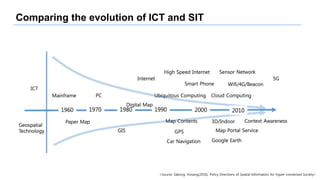
  • 8. Comparing the evolution of ICT and SIT <Source: Sakong, Hosang(2016), Policy Directions of Spatial Information for Hyper-connected Society>
  • 9. Change Process of Spatial Information <Source: Sakong, Hosang(2007)>
  • 11. Location Technology Evolution Source: 이기준, 2012, “공간정보관련 현안 이슈와 대응전략” 발표 자료를 재구성 Size of Space Number of Users 인구수 도시계획 국토건설네이게이션 인터넷 지도 스마트폰 LBS Person -> Things (IoT) 1980 1990 2000 2010 ~ 2020
  • 14. Location Technology Evolution <Source: Steve Liang(2016)> Location is the first class citizen for IoT!
  • 16. Location Technology Evolution Size of Space Mobility Small 1980 1990 2000 2010 ~ 2020 Large Static Dynamic <Source: Sakong, Hosang(2016), Policy Directions of Spatial Information for Hyper-connected Society>
  • 17. Location Technology Evolution <Source: Thomas W. Oestreich(2015), “Location, the Next Champion in Analytics”, Gartner Group.
  • 18. IoT, Big Data and A.I. 감각 기관 기억 지능 IoT(Internet of Things) Big Data A. I. Smartizen(10Bn) Smart Devices(100Bn) Smart Sensor(100Tn) <Source: 이상훈(2016), ‘ICT 기술 파도와 4차 산업혁명’을 수정, 재편집>
  • 19. Paradigm Shift of Location Technology Current Future Concept Object Information Context Awareness Data Consumer Prosumer/DIY User Person Things Visualization Real World Cyber-Physical Space Application Base Map Key Factor for Fusion Driving Entity Public Sector Private Sector Space Outdoor Indoor + Outdoor + Update Static Dynamic <Source: Sakong, Hosang(2016), ‘Policy Directions of Spatial Information for Hyper-connected Society’ 수정>
  • 22. A Platform. Goal. Integration from space to desktop in a single platform1 Management/Providing on various type of GIS data including indoor/outdoor and point cloud. 2 For 4D over 2D/3D merging3 Processing/Visualization on real-time massive data such like weather, IOT, and etc 4
  • 23. Identity? Base Lineup Base Lineup packaging Base Lineup GeoSHAPE GeoGig ?MAGO3D Purely open source based!
  • 24. Identity. 3D2D operation & analysis IoT Interface Base Lineup Enhancement server service functionality To-Be. Base Lineup 3D FunctionalityMAGO3D
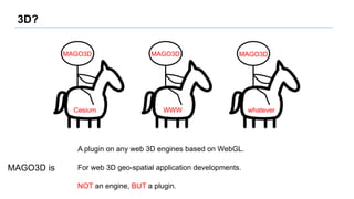
  • 25. 3D? Cesium MAGO3D WWW MAGO3D whatever MAGO3D A plugin on any web 3D engines based on WebGL. For web 3D geo-spatial application developments. NOT an engine, BUT a plugin. MAGO3D is
  • 26. 3D visualization with MAGO3D on Cesium Plugin on Cesium(HTML5)
  • 27. 3D visualization with MAGO3D on WWW Plugin on Web World Wind(HTML5)
  • 28. Functionality? Geo - Spatial I don’t know about geo stuffs. I just need ‘map’ in my service. A GIS platform should give more general-purpose functions to be used widely, even in non-GIS-specific fields.
  • 29. Functionality. To offer functionalities which is on or can be coupled with geo-spatial To makes easy approach/handling on function results in 2D/3D environments. &
  • 30. What we are doing with MAGO3D.
  • 31. Indoor Handling scene from indoor to outdoor through windows vice versa Seamless integration between indoor and outdoor.
  • 32. Indoor Handling MAGO3D can handle massive indoor data to the extend that at least 100k objects can be in a scene. power plant and flow system in a camp in Antarctic
  • 33. Indoor data model invented for indoor handling object 1 object 2 object 3 object 4 object 5 object 6 …raw data indoor data model … mesh 1 mesh 2 mesh 3 model meshes object 1 : mesh 3 + transform matrix + color object 2 : mesh 1 + transform matrix + color object 3 : mesh 2 + transform matrix + color object 4 : mesh 3 + transform matrix + color object 5 : mesh 3 + transform matrix + color object 6 : mesh 2 + transform matrix + color … instances info
  • 34. LiveDroneMap mosaic pluginFTP server MAGO3D image process with gdal - null value trimming - format conversion (to GeoTiff) - SRS conversion (to EPSG:4326) - building tile pyramid WMS tiled=true, format=image/png Time less than 5 min taken to process from FTP receiving to MAGO3D visualization with 41 drone-captured images. .jpg + .jgw LTE monitoring python
  • 35. LiveDroneMap LiveDroneMap can be useful in various fields, specially in fields with priority for urgency such like emergency/disaster prevention or monitoring.
  • 36. LiveDroneMap – Realtime Data Processing <Source: 서울시립대학교 센서 및 모델링 연구실(2016)>
  • 37. LiveDroneMap – Rapid Post Processing <Source: 서울시립대학교 센서 및 모델링 연구실(2016)>
  • 38. What we will do with MAGO3D.
  • 39. Data Type Scope Extension meteorological/weather data real-time data (IOT, sensor/observation data) point cloud MAGO3D will be capable of handling more types of data.
  • 40. Functionality Enhancement MAGO3D will have more functionalities on operation, analysis, UI, and styling visualization. type items analysis density map, standard ellipse, cost expectation over cost surface data, whisker analysis, detection abnormality from IOT data, etc operation raster operation(filtering, smoothing…), coverage rebuild, etc styling volume rendering, 3D vector/streamline, cubing, etc
  • 41. Server-side Extension Server structure will be implemented to make MAGO3D an enterprise-level platform. 3D Service/Data Extensions Operation/Analysis Extensions Data Importer/Exporter Data Providing Server Plugins on Web 3D Engines Plugins for styling visualization Default Web Client Web Application Server Server-side
  • 43. All source codes are available at https://github.com/gaia3d Thank you!