SlideShare a Scribd company logo
Perform. Xcel. Lead.
Presenter
Raghavendran S
FME Certified Professional
&
FME Certified Trainer
Data Explosion
Imagine the good old days, at any event!
And today...
Information Explosion/ Big Data Facts
In the networked world today
of Clicks and Likes, do we
realise the vast amount of
data generated in a minute or
60 seconds?
Information Explosion/ Big Data Facts
• Internet of Things (IoTs)
• Gartner (Year 2017)
Number of Connected Devices
(8.4bn)
Up 31% (2016)
>
World Population (7.5 bn) 20.8bn connected devices by 2020
GIS is evolving…
Accessibility
Time
Desktop GIS
Web GIS
Enterprise GIS
Cloud GIS
Mobile GIS
LiDAR
Geospatial (Big) Data: Some Examples
Geospatial
(Big) Data
Sensors
Location
LiDARRemote Sensing
IoT
Others
Satellite Imagery
UAV
Sensor based
Real time Monitoring
Crowdsourcing
Attribute/ Textual/Video/Photo
etc
The Geospatial CURSE!
Are you a GIS User or Organization
generating and or consuming geospatial data;
suddenly finding yourself with so much of data
(the curse!)
Is data a CURSE for your GIS?
GIS
Magic of Transformation
GIS
GIS
Data for GIS: A different perspective
YOUR DATA
Data that you create/ author/own
OTHERS DATA
Data from other sources/created by
others
Data for GIS: Data is Power
OTHER’s DATA
Data from other sources
Created by others
Open data
Neogeography
Volunteered geographic information (VGI)/Crowdsourcing
Data for GIS: Magic of Transformation
YOUR DATA
Data that you create/ author/own
Create
(Create/Edit/Modify/Update)
Process/
Analyze
Publish
Share
To fully realize the capability and benefits of
geographic information and GIS, spatial data
needs to be shared & systems need to be
interoperable
GIS data interoperability is the key!
GIS interoperability: Key to spatial data sharing
GIS Interoperability
Unlock your GIS data from GIS formats: Magic of Transformation!
Bottlenecks to GIS interoperability
Formats mentioned here are for representative purposes only
Bottlenecks to GIS interoperability
One magic (size) does
not work for (fit) all!
It isn’t just
about format!
Bottlenecks to GIS interoperability
GIS
It isn’t just about format!
 Data format
 Data model
 Schema
 Data quality issues
 Content issues
 Coordinate/Projection issues
 Data sharing framework
 Data sharing policy
 Semantics…
Bottlenecks to GIS interoperability
Magic of Transformation:
GIS Interoperability
With so many GIS formats, achieving GIS interoperability
is no doubt a difficult magic trick!
Magic of Transformation: GIS Interoperability
Rise above GIS file format barriers and achieve total
spatial data mastery
FME (Feature Manipulation Engine)
a spatial ETL (Extract, Transform & Load) tool
from
Safe Software, Inc., Canada
FME : Formats don’t matter !
You name the format…Support for over 400+ CAD/
GIS/Database/Web formats (including several OGC formats)
Convert spatial data between
hundreds of formats
Transform spatial data into the
precise data model you need
Integrate multiple different data
types into a single data model
Share spatial data with people
where, when and how they need it
FME Capabilities: Magic of Transformation
Format A to Format B
SIMPLE TRANSLATION WITH OR WITHOUT DATA
MODEL TRANSFORMATION
SEMANTIC TRANSLATION
FME & Magic of Transformation: GIS Interoperability
ONE - TO - MANY FORMATS
DATA SHARING
SEMANTIC TRANSLATION
(DATA MODEL TRANSFORMATION)
FME & Magic of Transformation: GIS Interoperability
MANY – TO -ONE FORMAT
INTEGRATION
SEMANTIC TRANSLATION
(DATA MODEL TRANSFORMATION
TO A COMMON AGREED GIS DATA MODEL)
FME & Magic of Transformation: GIS Interoperability
MANY – TO -MANY FORMATS
SEMANTIC TRANSLATION
(DATA MODEL TRANSFORMATION)
FME & Magic of Transformation: GIS Interoperability
Manipulate your Data across DATA TYPES
FME & Magic of Transformation: GIS Interoperability
FME: Feature Manipulation Engine
FME Desktop
FME Server
FME Cloud
CREATE AND RUN WORKFLOWS
FME Desktop lets you connect and transform data in
limitless ways.
AUTOMATE WORKFLOWS (ON-PREMISE)
FME Server provides enterprise-level access to FME's
powerful capabilities.
AUTOMATE WORKFLOWS (CLOUD)
FME Cloud is the hosted version of FME Server. No
hardware required.
Node Locked
or
Fixed License
Floating
or
Concurrent
License
FME Desktop Licensing
Smallworld Edition
Database Edition
Esri/Intergraph Edition
FME Desktop Editions
Professional Edition
FME Workbench
Intuitive graphical interface to model data
transformation workflows
FME Data Inspector
Inspect your data (data's attributes and geometry)
before, after and during translation
FME Quick Translator
An interface for quickly executing simple one-to-
one format conversions.
FME Desktop Components
FME Server: Enterprise automation
FME Desktop
Author and run
spatial transformation
tasks
FME Server
Run and share
spatial transformation
capabilities
Federate
GIS data
EndUsers/Applications
Consume
GIS data
Transform
GIS data
(on the fly)
Create
GIS data
Internet
/
Intranet
Internet/
Intranet
Spatial Data Sharing: FME Desktop and Server
Disseminate data in over
400+ formats
EndUsers/Applications
Disseminate
data in over
400+ formats
ISO OGC
Discovery Service
WMS
WFS
WCS
Viewer
Geoportal
GIS data Internet/
Intranet
Internet/
Intranet
Spatial Data Sharing: FME and GIS data portal
Federate
GIS data
Transform
GIS data
(on the fly)
Create
GIS data
Consume
GIS data
FME Desktop & FME Server
Thank You
www.pixelsoftek.in
safe@pixelsoftek.com
Perform. Xcel. Lead.
Raghavendran (aka SRG)
raghavendran@pixelsoftek.com

More Related Content

What's hot (20)

PDF
Choosing the Right Transformer for Your Data Challenge
Safe Software
 
PDF
5 Ways to Improve Your LiDAR Workflows
Safe Software
 
PDF
Visualizing Data in a Web Browser with Cesium ion & FME
Safe Software
 
PDF
Tips & Tricks for Using FME for Business Intelligence
Safe Software
 
PPT
Preparing LiDAR for Use in ArcGIS 10.1 with the Data Interoperability Extension
Safe Software
 
PPTX
Connecting Any Web Services
Safe Software
 
PPTX
Gain Total Control of Your LiDAR and Point Cloud Data
Safe Software
 
PDF
The Masked Revit User: Exploring Limitless Possibilities
Safe Software
 
PDF
Tools for Visualizing Geospatial Data in a Web Browser
Safe Software
 
PDF
Application Integration for Smart Cities
Safe Software
 
PDF
FME Spatial Querying in a CAD-Driven GIS
Safe Software
 
PPTX
Using FME to Deliver Map-Based Geological Data for Oil & Gas Companies
Safe Software
 
PPT
Prepare LiDAR Data To Meet Your Requirements
Safe Software
 
PPT
Knime
Amal Targhi
 
PPTX
Real-Time Analytics with Spark and MemSQL
SingleStore
 
PPTX
Driving the On-Demand Economy with Predictive Analytics
SingleStore
 
PDF
The Fast Path to Building Operational Applications with Spark
SingleStore
 
PDF
Bridging the Gap Between Unequal Partners
Safe Software
 
PPTX
Introduction to knime
Bernardo Najlis
 
PDF
Leveraging Autodesk Products with FME: AutoCAD to GIS is Only the Beginning
Safe Software
 
Choosing the Right Transformer for Your Data Challenge
Safe Software
 
5 Ways to Improve Your LiDAR Workflows
Safe Software
 
Visualizing Data in a Web Browser with Cesium ion & FME
Safe Software
 
Tips & Tricks for Using FME for Business Intelligence
Safe Software
 
Preparing LiDAR for Use in ArcGIS 10.1 with the Data Interoperability Extension
Safe Software
 
Connecting Any Web Services
Safe Software
 
Gain Total Control of Your LiDAR and Point Cloud Data
Safe Software
 
The Masked Revit User: Exploring Limitless Possibilities
Safe Software
 
Tools for Visualizing Geospatial Data in a Web Browser
Safe Software
 
Application Integration for Smart Cities
Safe Software
 
FME Spatial Querying in a CAD-Driven GIS
Safe Software
 
Using FME to Deliver Map-Based Geological Data for Oil & Gas Companies
Safe Software
 
Prepare LiDAR Data To Meet Your Requirements
Safe Software
 
Real-Time Analytics with Spark and MemSQL
SingleStore
 
Driving the On-Demand Economy with Predictive Analytics
SingleStore
 
The Fast Path to Building Operational Applications with Spark
SingleStore
 
Bridging the Gap Between Unequal Partners
Safe Software
 
Introduction to knime
Bernardo Najlis
 
Leveraging Autodesk Products with FME: AutoCAD to GIS is Only the Beginning
Safe Software
 

Similar to Your Data and FME (20)

PPTX
Managing data interoperability with FME
IMGS
 
PDF
Your Data Eco System and FME
Raghavendran S
 
PPTX
FME Overview Workshop_Tony Kent & Ciaran Kirk - AGI Belfast 2013
IMGS
 
PDF
Data is Power
Raghavendran S
 
PDF
Bridging Between CAD & GIS - 8 Ways to Automate Your Data Integration.pdf
Safe Software
 
PDF
How to Automate CAD & GIS Integration
Safe Software
 
PPTX
Utilities Industry Success Stories with FME
Safe Software
 
PDF
Marrying FME & ArcGIS: Automating GIS Workflows for Maximum Efficiency
Safe Software
 
PDF
Fme - What For?
Innovatech GIS
 
PDF
Bridging Between CAD & GIS: 6 Ways to Automate Your Data Integration
marketing932765
 
PDF
Bridging Between CAD & GIS: 6 Ways to Automate Your Data Integration
Safe Software
 
PDF
Bridging Between CAD & GIS: 6 Ways to Automate Your Data Integration
marketing932765
 
PPTX
Using FME to support open data initiatives and INSPIRE
IMGS
 
PPTX
Enabling Spatial Decision Support and Analytics on a Campus Scale with FME Te...
Safe Software
 
PPTX
How to Exchange Data between CAD and GIS
Safe Software
 
PDF
An Introduction to All Data Enterprise Integration
Safe Software
 
PPTX
How to Transform Data between AutoCAD and GIS
Safe Software
 
PPTX
Converting the City’s Electrical Data from Smallworld to Microstation Format
Safe Software
 
PPTX
FME Technology: Batteries Included
Safe Software
 
PDF
Leveraging Data Integration for Strategic GIS Governance
Safe Software
 
Managing data interoperability with FME
IMGS
 
Your Data Eco System and FME
Raghavendran S
 
FME Overview Workshop_Tony Kent & Ciaran Kirk - AGI Belfast 2013
IMGS
 
Data is Power
Raghavendran S
 
Bridging Between CAD & GIS - 8 Ways to Automate Your Data Integration.pdf
Safe Software
 
How to Automate CAD & GIS Integration
Safe Software
 
Utilities Industry Success Stories with FME
Safe Software
 
Marrying FME & ArcGIS: Automating GIS Workflows for Maximum Efficiency
Safe Software
 
Fme - What For?
Innovatech GIS
 
Bridging Between CAD & GIS: 6 Ways to Automate Your Data Integration
marketing932765
 
Bridging Between CAD & GIS: 6 Ways to Automate Your Data Integration
Safe Software
 
Bridging Between CAD & GIS: 6 Ways to Automate Your Data Integration
marketing932765
 
Using FME to support open data initiatives and INSPIRE
IMGS
 
Enabling Spatial Decision Support and Analytics on a Campus Scale with FME Te...
Safe Software
 
How to Exchange Data between CAD and GIS
Safe Software
 
An Introduction to All Data Enterprise Integration
Safe Software
 
How to Transform Data between AutoCAD and GIS
Safe Software
 
Converting the City’s Electrical Data from Smallworld to Microstation Format
Safe Software
 
FME Technology: Batteries Included
Safe Software
 
Leveraging Data Integration for Strategic GIS Governance
Safe Software
 
Ad

More from Raghavendran S (6)

PPTX
Location is Everything
Raghavendran S
 
PDF
Transforming Rasters and Point Clouds using FME
Raghavendran S
 
PDF
CAD & GIS-Connecting the Two Worlds
Raghavendran S
 
PPTX
Small Things of Big (Geospatial) Data
Raghavendran S
 
PPTX
Geospatial Intelligence:The "Safe" Way
Raghavendran S
 
PPTX
Data is Power
Raghavendran S
 
Location is Everything
Raghavendran S
 
Transforming Rasters and Point Clouds using FME
Raghavendran S
 
CAD & GIS-Connecting the Two Worlds
Raghavendran S
 
Small Things of Big (Geospatial) Data
Raghavendran S
 
Geospatial Intelligence:The "Safe" Way
Raghavendran S
 
Data is Power
Raghavendran S
 
Ad

Recently uploaded (20)

PDF
The 5 Reasons for IT Maintenance - Arna Softech
Arna Softech
 
PDF
Generic or Specific? Making sensible software design decisions
Bert Jan Schrijver
 
PPTX
Foundations of Marketo Engage - Powering Campaigns with Marketo Personalization
bbedford2
 
PPTX
Finding Your License Details in IBM SPSS Statistics Version 31.pptx
Version 1 Analytics
 
PDF
AI + DevOps = Smart Automation with devseccops.ai.pdf
Devseccops.ai
 
PDF
Download Canva Pro 2025 PC Crack Full Latest Version
bashirkhan333g
 
PPTX
AEM User Group: India Chapter Kickoff Meeting
jennaf3
 
PDF
Top Agile Project Management Tools for Teams in 2025
Orangescrum
 
PPTX
Agentic Automation: Build & Deploy Your First UiPath Agent
klpathrudu
 
PPTX
In From the Cold: Open Source as Part of Mainstream Software Asset Management
Shane Coughlan
 
PDF
NEW-Viral>Wondershare Filmora 14.5.18.12900 Crack Free
sherryg1122g
 
PDF
Automate Cybersecurity Tasks with Python
VICTOR MAESTRE RAMIREZ
 
PDF
Build It, Buy It, or Already Got It? Make Smarter Martech Decisions
bbedford2
 
PPTX
Help for Correlations in IBM SPSS Statistics.pptx
Version 1 Analytics
 
PPTX
Empowering Asian Contributions: The Rise of Regional User Groups in Open Sour...
Shane Coughlan
 
PDF
Technical-Careers-Roadmap-in-Software-Market.pdf
Hussein Ali
 
PDF
MiniTool Power Data Recovery 8.8 With Crack New Latest 2025
bashirkhan333g
 
PPTX
Coefficient of Variance in IBM SPSS Statistics Version 31.pptx
Version 1 Analytics
 
PDF
MiniTool Partition Wizard Free Crack + Full Free Download 2025
bashirkhan333g
 
PDF
유니티에서 Burst Compiler+ThreadedJobs+SIMD 적용사례
Seongdae Kim
 
The 5 Reasons for IT Maintenance - Arna Softech
Arna Softech
 
Generic or Specific? Making sensible software design decisions
Bert Jan Schrijver
 
Foundations of Marketo Engage - Powering Campaigns with Marketo Personalization
bbedford2
 
Finding Your License Details in IBM SPSS Statistics Version 31.pptx
Version 1 Analytics
 
AI + DevOps = Smart Automation with devseccops.ai.pdf
Devseccops.ai
 
Download Canva Pro 2025 PC Crack Full Latest Version
bashirkhan333g
 
AEM User Group: India Chapter Kickoff Meeting
jennaf3
 
Top Agile Project Management Tools for Teams in 2025
Orangescrum
 
Agentic Automation: Build & Deploy Your First UiPath Agent
klpathrudu
 
In From the Cold: Open Source as Part of Mainstream Software Asset Management
Shane Coughlan
 
NEW-Viral>Wondershare Filmora 14.5.18.12900 Crack Free
sherryg1122g
 
Automate Cybersecurity Tasks with Python
VICTOR MAESTRE RAMIREZ
 
Build It, Buy It, or Already Got It? Make Smarter Martech Decisions
bbedford2
 
Help for Correlations in IBM SPSS Statistics.pptx
Version 1 Analytics
 
Empowering Asian Contributions: The Rise of Regional User Groups in Open Sour...
Shane Coughlan
 
Technical-Careers-Roadmap-in-Software-Market.pdf
Hussein Ali
 
MiniTool Power Data Recovery 8.8 With Crack New Latest 2025
bashirkhan333g
 
Coefficient of Variance in IBM SPSS Statistics Version 31.pptx
Version 1 Analytics
 
MiniTool Partition Wizard Free Crack + Full Free Download 2025
bashirkhan333g
 
유니티에서 Burst Compiler+ThreadedJobs+SIMD 적용사례
Seongdae Kim
 

Your Data and FME

  • 1. Perform. Xcel. Lead. Presenter Raghavendran S FME Certified Professional & FME Certified Trainer
  • 2. Data Explosion Imagine the good old days, at any event! And today...
  • 3. Information Explosion/ Big Data Facts In the networked world today of Clicks and Likes, do we realise the vast amount of data generated in a minute or 60 seconds?
  • 5. Information Explosion/ Big Data Facts • Internet of Things (IoTs) • Gartner (Year 2017) Number of Connected Devices (8.4bn) Up 31% (2016) > World Population (7.5 bn) 20.8bn connected devices by 2020
  • 6. GIS is evolving… Accessibility Time Desktop GIS Web GIS Enterprise GIS Cloud GIS Mobile GIS
  • 7. LiDAR Geospatial (Big) Data: Some Examples Geospatial (Big) Data Sensors Location LiDARRemote Sensing IoT Others Satellite Imagery UAV Sensor based Real time Monitoring Crowdsourcing Attribute/ Textual/Video/Photo etc
  • 8. The Geospatial CURSE! Are you a GIS User or Organization generating and or consuming geospatial data; suddenly finding yourself with so much of data (the curse!)
  • 9. Is data a CURSE for your GIS? GIS
  • 11. Data for GIS: A different perspective YOUR DATA Data that you create/ author/own OTHERS DATA Data from other sources/created by others
  • 12. Data for GIS: Data is Power OTHER’s DATA Data from other sources Created by others Open data Neogeography Volunteered geographic information (VGI)/Crowdsourcing
  • 13. Data for GIS: Magic of Transformation YOUR DATA Data that you create/ author/own Create (Create/Edit/Modify/Update) Process/ Analyze Publish Share
  • 14. To fully realize the capability and benefits of geographic information and GIS, spatial data needs to be shared & systems need to be interoperable GIS data interoperability is the key! GIS interoperability: Key to spatial data sharing
  • 15. GIS Interoperability Unlock your GIS data from GIS formats: Magic of Transformation!
  • 16. Bottlenecks to GIS interoperability Formats mentioned here are for representative purposes only
  • 17. Bottlenecks to GIS interoperability One magic (size) does not work for (fit) all!
  • 18. It isn’t just about format! Bottlenecks to GIS interoperability
  • 19. GIS It isn’t just about format!  Data format  Data model  Schema  Data quality issues  Content issues  Coordinate/Projection issues  Data sharing framework  Data sharing policy  Semantics… Bottlenecks to GIS interoperability
  • 20. Magic of Transformation: GIS Interoperability With so many GIS formats, achieving GIS interoperability is no doubt a difficult magic trick!
  • 21. Magic of Transformation: GIS Interoperability
  • 22. Rise above GIS file format barriers and achieve total spatial data mastery
  • 23. FME (Feature Manipulation Engine) a spatial ETL (Extract, Transform & Load) tool from Safe Software, Inc., Canada
  • 24. FME : Formats don’t matter ! You name the format…Support for over 400+ CAD/ GIS/Database/Web formats (including several OGC formats)
  • 25. Convert spatial data between hundreds of formats Transform spatial data into the precise data model you need Integrate multiple different data types into a single data model Share spatial data with people where, when and how they need it FME Capabilities: Magic of Transformation
  • 26. Format A to Format B SIMPLE TRANSLATION WITH OR WITHOUT DATA MODEL TRANSFORMATION SEMANTIC TRANSLATION FME & Magic of Transformation: GIS Interoperability
  • 27. ONE - TO - MANY FORMATS DATA SHARING SEMANTIC TRANSLATION (DATA MODEL TRANSFORMATION) FME & Magic of Transformation: GIS Interoperability
  • 28. MANY – TO -ONE FORMAT INTEGRATION SEMANTIC TRANSLATION (DATA MODEL TRANSFORMATION TO A COMMON AGREED GIS DATA MODEL) FME & Magic of Transformation: GIS Interoperability
  • 29. MANY – TO -MANY FORMATS SEMANTIC TRANSLATION (DATA MODEL TRANSFORMATION) FME & Magic of Transformation: GIS Interoperability
  • 30. Manipulate your Data across DATA TYPES FME & Magic of Transformation: GIS Interoperability
  • 31. FME: Feature Manipulation Engine FME Desktop FME Server FME Cloud CREATE AND RUN WORKFLOWS FME Desktop lets you connect and transform data in limitless ways. AUTOMATE WORKFLOWS (ON-PREMISE) FME Server provides enterprise-level access to FME's powerful capabilities. AUTOMATE WORKFLOWS (CLOUD) FME Cloud is the hosted version of FME Server. No hardware required.
  • 33. Smallworld Edition Database Edition Esri/Intergraph Edition FME Desktop Editions Professional Edition
  • 34. FME Workbench Intuitive graphical interface to model data transformation workflows FME Data Inspector Inspect your data (data's attributes and geometry) before, after and during translation FME Quick Translator An interface for quickly executing simple one-to- one format conversions. FME Desktop Components
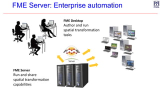
  • 35. FME Server: Enterprise automation FME Desktop Author and run spatial transformation tasks FME Server Run and share spatial transformation capabilities
  • 36. Federate GIS data EndUsers/Applications Consume GIS data Transform GIS data (on the fly) Create GIS data Internet / Intranet Internet/ Intranet Spatial Data Sharing: FME Desktop and Server Disseminate data in over 400+ formats
  • 37. EndUsers/Applications Disseminate data in over 400+ formats ISO OGC Discovery Service WMS WFS WCS Viewer Geoportal GIS data Internet/ Intranet Internet/ Intranet Spatial Data Sharing: FME and GIS data portal Federate GIS data Transform GIS data (on the fly) Create GIS data Consume GIS data
  • 38. FME Desktop & FME Server