Geospatial Enhancements in MongoDB 2.4
4 likes4,253 views

This document summarizes MongoDB's geospatial features including 2d and 2dsphere indexing, GeoJSON support for lines and polygons, and geospatial aggregation. It provides examples of querying points and geometries within regions, near points, and intersecting geometries. Future plans include additional geospatial predicates and indexing composite shapes.


![[ from Jpatokal at wikimedia.org ]
https://secure.wikimedia.org/wikipedia/commons/wiki/File:World-airline-routemap-2009.png](https://image.slidesharecdn.com/studerpresentation-130625132628-phpapp01/85/Geospatial-Enhancements-in-MongoDB-2-4-4-320.jpg)
![[ from Jpatokal at wikimedia.org ]
https://secure.wikimedia.org/wikipedia/commons/wiki/File:World-airline-routemap-2009.png](https://image.slidesharecdn.com/studerpresentation-130625132628-phpapp01/85/Geospatial-Enhancements-in-MongoDB-2-4-5-320.jpg)


![// Make a flat 2d index [-180 -> 180)
> db.coll.ensureIndex(
{ location : "2d", type : 1 } )
// Insert some point data
> db.coll.insert({ name : "Shake Shack",
type : "rest",
location : [ -73.9881353, 40.7415064 ]
})
> db.coll.insert({ name : "Park Avenue
Tavern", type : "bar",
location : [ -73.9786924, 40.7502231 ]
})](https://image.slidesharecdn.com/studerpresentation-130625132628-phpapp01/85/Geospatial-Enhancements-in-MongoDB-2-4-9-320.jpg)
![// Find in Manhattan Mall
> db.coll.find({ location : { $geoWithin : {
$polygon : [[ -73.9884761, 40.7491204 ],
[ -73.988829, 40.7486387 ],
[ -73.9901297, 40.7491856 ],
[ -73.9897768, 40.7496673 ],
[ -73.9884761, 40.7491204 ]] }}},
type : "rest" })
// Find near Washington Square (center)
> db.coll.find({ location : {
$geoNear : [ -73.7695467, 42.6622728 ] },
type : "rest" });](https://image.slidesharecdn.com/studerpresentation-130625132628-phpapp01/85/Geospatial-Enhancements-in-MongoDB-2-4-10-320.jpg)

![GeoJSON
● Widely supported open JSON standard
http://www.geojson.org/
● Simple language:
{ type : 'Point',
coordinates : [<lon>, <lat>] }
{ type : 'LineString',
coordinates : [[<lon>, <lat>],...] }
{ type : 'Polygon',
coordinates : [[[<lon>,<lat>],...],...]}
+ other MultiXXX types (future) ...](https://image.slidesharecdn.com/studerpresentation-130625132628-phpapp01/85/Geospatial-Enhancements-in-MongoDB-2-4-13-320.jpg)
![// Make a spherical 2d compound index
> db.coll.ensureIndex(
{ type : 1, location : "2dsphere" } )
// Insert Park Avenue
> db.coll.insert(
{ name : "Park Avenue", type : "road",
location : { type : 'LineString',
coordinates : [
[ -73.9359712600708, 40.80942429324451],
[ -73.93676519393921, 40.80820620367037],
... ]} });](https://image.slidesharecdn.com/studerpresentation-130625132628-phpapp01/85/Geospatial-Enhancements-in-MongoDB-2-4-14-320.jpg)
![// Insert Great Hill
> db.coll.insert(
{ name : "Great Hill", type : "park",
location : { type : 'Polygon',
coordinates : [[
[ -73.95841598510742, 40.79724239132546],
[ -73.95817995071411, 40.79691751000055],
... ]]} });](https://image.slidesharecdn.com/studerpresentation-130625132628-phpapp01/85/Geospatial-Enhancements-in-MongoDB-2-4-15-320.jpg)
![// Find docs with geometry that intersects
// a route
> db.coll.find({ location :
{ $geoIntersects : { $geometry :
{ type : 'LineString',
// Run coordinates
coordinates : [
[ -73.95586252212524, 40.77964777966238 ],
[ -73.95886659622192, 40.78091513739611 ],
... ]} }}})](https://image.slidesharecdn.com/studerpresentation-130625132628-phpapp01/85/Geospatial-Enhancements-in-MongoDB-2-4-16-320.jpg)


![> db.ny.aggregate([
// Find everything in MidTown/Hell's Kitchen
{ $match : { geo: { $geoWithin: { $geometry:
{ type: "Polygon", coordinates: [[
// Midtown/Hell's Kitchen
[ -73.9984130859375, 40.78028146155187 ],
[ -73.95240783691406, 40.76182096906601 ],
[ -73.96888732910156, 40.73945350425846 ],
[ -74.01420593261719, 40.75531957477602 ],
[ -73.9984130859375, 40.78028146155187 ]
]] } } } } },
...](https://image.slidesharecdn.com/studerpresentation-130625132628-phpapp01/85/Geospatial-Enhancements-in-MongoDB-2-4-24-320.jpg)
![...
// Organize stuff we want
{ $project :
{ tags : 1,
info : { name : "$name",
lonLat : "$geo.coordinates" }} },
{ $unwind : "$tags" },
// Count by tag types
{ $group : { _id : "$tags",
total : { $sum : 1 },
locs : { $push : "$info" } }}
]); // end](https://image.slidesharecdn.com/studerpresentation-130625132628-phpapp01/85/Geospatial-Enhancements-in-MongoDB-2-4-25-320.jpg)
![{ "result" : [
{ "_id" : "park", "total" : 18,
"locs" : [{
"name" : "Hells Kitchen Park",
"lonLat" : [ -73.9925, 40.7630556 ] },
...
{ "_id" : "bar", "total" : 28,
"locs" : [
{ "name" : "Landmark Tavern",
"lonLat" : [ -73.9963261, 40.7631922 ] },
{ "name" : "Pony Bar",
"lonLat" : [ -73.994236, 40.761723 ] },
...
...](https://image.slidesharecdn.com/studerpresentation-130625132628-phpapp01/85/Geospatial-Enhancements-in-MongoDB-2-4-26-320.jpg)
![> db.ny.aggregate([
// Find near Times Square
{ $geoNear : {
near : {
type: "Point",
// Times Square
coordinates: [ -73.98508787155151,
40.75905795418586 ] },
distanceField : "distance",
spherical : true, // 2dsphere
num : 1000 } },
...](https://image.slidesharecdn.com/studerpresentation-130625132628-phpapp01/85/Geospatial-Enhancements-in-MongoDB-2-4-27-320.jpg)
![...
// Organize stuff we want
{ $project :
{ tags : 1,
info : { name : "$name",
distance : "$distance",
lonLat : "$geo.coordinates" }} },
{ $unwind : "$tags" },
// Count by tag types
{ $group : { _id : "$tags",
total : { $sum : 1 },
locs : { $push : "$info" } }}
]); // end
...](https://image.slidesharecdn.com/studerpresentation-130625132628-phpapp01/85/Geospatial-Enhancements-in-MongoDB-2-4-28-320.jpg)
![{ "result" : [
{ "_id" : "park", "total" : 11,
"locs" : [{
"name" : "Ramone Aponte Park",
"distance" : 449.7417003854033, // m
"lonLat" : [ -73.9894444, 40.7613889 ]},
...
{ "_id" : "bar", "total" : 24,
"locs" : [{
"name" : "The Lambs Club",
"distance" : 275.0270424641914, // m
"lonLat" : [ -73.9963261, 40.7631922 ]},
...
...](https://image.slidesharecdn.com/studerpresentation-130625132628-phpapp01/85/Geospatial-Enhancements-in-MongoDB-2-4-29-320.jpg)
![[ from Jpatokal at wikimedia.org ]
https://secure.wikimedia.org/wikipedia/commons/wiki/File:World-airline-routemap-2009.png](https://image.slidesharecdn.com/studerpresentation-130625132628-phpapp01/85/Geospatial-Enhancements-in-MongoDB-2-4-30-320.jpg)


Geospatial Enhancements in MongoDB 2.4
- 1. Map the Globe, simply Polygon indexing and GeoJSON support in MongoDB Greg Studer [email protected] mongoNYC 2013
- 2. ● 2d vs 2dsphere ● (Quick) overview of previous geospatial features in MongoDB ● New line/polygon indexing on spherical globe GeoJSON - lines and polygons ● Geo in aggregation ● Future Roadmap
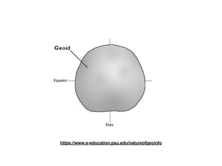
- 3. Why use (2dsphere) geospatial indexing? 1. Have earth-like coordinates and regions tagged to other data over large areas 2. Want to query this data based on location 3. Don't necessarily want to think a lot about the fact that the earth is round
- 4. [ from Jpatokal at wikimedia.org ] https://secure.wikimedia.org/wikipedia/commons/wiki/File:World-airline-routemap-2009.png
- 5. [ from Jpatokal at wikimedia.org ] https://secure.wikimedia.org/wikipedia/commons/wiki/File:World-airline-routemap-2009.png
- 7. Why use (2d) geospatial indexing? 1. Have regional or virtual world coordinates embedded in other data 2. (For now) Only indexing locations 3. Don't want spherical overhead
- 8. Overview of geo features ● 2.2 - "2d" Index only (multi-)points Query near points or within simple polygons
- 9. // Make a flat 2d index [-180 -> 180) > db.coll.ensureIndex( { location : "2d", type : 1 } ) // Insert some point data > db.coll.insert({ name : "Shake Shack", type : "rest", location : [ -73.9881353, 40.7415064 ] }) > db.coll.insert({ name : "Park Avenue Tavern", type : "bar", location : [ -73.9786924, 40.7502231 ] })
- 10. // Find in Manhattan Mall > db.coll.find({ location : { $geoWithin : { $polygon : [[ -73.9884761, 40.7491204 ], [ -73.988829, 40.7486387 ], [ -73.9901297, 40.7491856 ], [ -73.9897768, 40.7496673 ], [ -73.9884761, 40.7491204 ]] }}}, type : "rest" }) // Find near Washington Square (center) > db.coll.find({ location : { $geoNear : [ -73.7695467, 42.6622728 ] }, type : "rest" });
- 11. Overview of geo features ● 2.2 - "2d" DEMO - NYC OpenStreetMaps data github.com/mongodb/mongo-snippets/tree/master/2dsphere
- 12. Overview of geo features ● Current 2.4 - "2dsphere" Index points, lines, and polygons (on sphere) Understands simple GeoJSON Query with points, lines, and polygons Within-region, Intersect-region, Near-point queries
- 13. GeoJSON ● Widely supported open JSON standard http://www.geojson.org/ ● Simple language: { type : 'Point', coordinates : [<lon>, <lat>] } { type : 'LineString', coordinates : [[<lon>, <lat>],...] } { type : 'Polygon', coordinates : [[[<lon>,<lat>],...],...]} + other MultiXXX types (future) ...
- 14. // Make a spherical 2d compound index > db.coll.ensureIndex( { type : 1, location : "2dsphere" } ) // Insert Park Avenue > db.coll.insert( { name : "Park Avenue", type : "road", location : { type : 'LineString', coordinates : [ [ -73.9359712600708, 40.80942429324451], [ -73.93676519393921, 40.80820620367037], ... ]} });
- 15. // Insert Great Hill > db.coll.insert( { name : "Great Hill", type : "park", location : { type : 'Polygon', coordinates : [[ [ -73.95841598510742, 40.79724239132546], [ -73.95817995071411, 40.79691751000055], ... ]]} });
- 16. // Find docs with geometry that intersects // a route > db.coll.find({ location : { $geoIntersects : { $geometry : { type : 'LineString', // Run coordinates coordinates : [ [ -73.95586252212524, 40.77964777966238 ], [ -73.95886659622192, 40.78091513739611 ], ... ]} }}})
- 17. Overview of geo features ● Current 2.4 - "2dsphere" DEMO - NYC OpenStreetMaps data github.com/mongodb/mongo-snippets/tree/master/2dsphere
- 18. Overview of geo features ● Current 2.4 - "2dsphere" Reduced shape distortion DEMO - NYC OpenStreetMaps data github.com/mongodb/mongo-snippets/tree/master/2dsphere
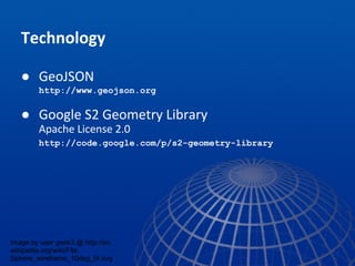
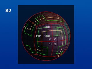
- 19. Technology ● GeoJSON http://www.geojson.org ● Google S2 Geometry Library Apache License 2.0 http://code.google.com/p/s2-geometry-library image by user geek3 @ http://en. wikipedia.org/wiki/File: Sphere_wireframe_10deg_6r.svg
- 20. S2
- 22. ● 2d vs 2dsphere ● (Quick) overview of previous geospatial features in MongoDB ● New line/polygon indexing on spherical globe GeoJSON - lines and polygons ● Geo in aggregation ● Future Roadmap
- 23. Overview of geo features ● Current 2.4 - aggregation support Geospatial predicates in aggregation Near sorting in aggregation, custom output fields
- 24. > db.ny.aggregate([ // Find everything in MidTown/Hell's Kitchen { $match : { geo: { $geoWithin: { $geometry: { type: "Polygon", coordinates: [[ // Midtown/Hell's Kitchen [ -73.9984130859375, 40.78028146155187 ], [ -73.95240783691406, 40.76182096906601 ], [ -73.96888732910156, 40.73945350425846 ], [ -74.01420593261719, 40.75531957477602 ], [ -73.9984130859375, 40.78028146155187 ] ]] } } } } }, ...
- 25. ... // Organize stuff we want { $project : { tags : 1, info : { name : "$name", lonLat : "$geo.coordinates" }} }, { $unwind : "$tags" }, // Count by tag types { $group : { _id : "$tags", total : { $sum : 1 }, locs : { $push : "$info" } }} ]); // end
- 26. { "result" : [ { "_id" : "park", "total" : 18, "locs" : [{ "name" : "Hells Kitchen Park", "lonLat" : [ -73.9925, 40.7630556 ] }, ... { "_id" : "bar", "total" : 28, "locs" : [ { "name" : "Landmark Tavern", "lonLat" : [ -73.9963261, 40.7631922 ] }, { "name" : "Pony Bar", "lonLat" : [ -73.994236, 40.761723 ] }, ... ...
- 27. > db.ny.aggregate([ // Find near Times Square { $geoNear : { near : { type: "Point", // Times Square coordinates: [ -73.98508787155151, 40.75905795418586 ] }, distanceField : "distance", spherical : true, // 2dsphere num : 1000 } }, ...
- 28. ... // Organize stuff we want { $project : { tags : 1, info : { name : "$name", distance : "$distance", lonLat : "$geo.coordinates" }} }, { $unwind : "$tags" }, // Count by tag types { $group : { _id : "$tags", total : { $sum : 1 }, locs : { $push : "$info" } }} ]); // end ...
- 29. { "result" : [ { "_id" : "park", "total" : 11, "locs" : [{ "name" : "Ramone Aponte Park", "distance" : 449.7417003854033, // m "lonLat" : [ -73.9894444, 40.7613889 ]}, ... { "_id" : "bar", "total" : 24, "locs" : [{ "name" : "The Lambs Club", "distance" : 275.0270424641914, // m "lonLat" : [ -73.9963261, 40.7631922 ]}, ... ...
- 30. [ from Jpatokal at wikimedia.org ] https://secure.wikimedia.org/wikipedia/commons/wiki/File:World-airline-routemap-2009.png
- 31. Future ● Further support for other predicates OGC Simple Features ● GeoJSON composite shapes ● Indexing API to allow similar enhancements for "flat plane" work ● Space open for non-default CRSes