Getting Started with Geospatial Data in MongoDB
Download as PPTX, PDF17 likes9,734 views

The document presents an overview of geospatial data capabilities in MongoDB, highlighting features such as the ability to store, query, and index geographical data using the GeoJSON format. It covers MongoDB's flexible data model, various indexing options, and use cases that demonstrate its effectiveness in geospatial analysis. Additionally, it compares MongoDB's approach to geospatial capabilities with that of the Open Geospatial Consortium (OGC) standards.


![3
MongoDB:
The Post-Relational General Purpose Database
Document
Data Model
Open-
Source
Fully Featured
High Performance
Scalable
{
name: “John Smith”,
pfxs: [“Dr.”,”Mr.”],
address: “10 3rd St.”,
phone: {
home: 1234567890,
mobile: 1234568138 }
}](https://image.slidesharecdn.com/orig-170517171400/85/Getting-Started-with-Geospatial-Data-in-MongoDB-3-320.jpg)


![17
Legacy: 2D points
{
name: {f: “Buzz”, l: “Moschetti”},
favoritePets: [ “dog”, “cat” ],
house: [ -95.12345, 43.23423 ]
}](https://image.slidesharecdn.com/orig-170517171400/85/Getting-Started-with-Geospatial-Data-in-MongoDB-17-320.jpg)
![18
Better: GeoJSON
{
name: {f: “Buzz”, l: “Moschetti”},
favoritePets: [ “dog”, “cat” ],
house: {
type: “Point”,
coordinates: [ -95.12345, 43.23423 ]
}
}](https://image.slidesharecdn.com/orig-170517171400/85/Getting-Started-with-Geospatial-Data-in-MongoDB-18-320.jpg)
![19
Better: GeoJSON
{
name: “Superfund132”,
location: {
type: “Polygon”,
coordinates: [
[ [-95.12345, 43.2342],[-95.12456,43.2351],…]
[ [-92.8381, 43.75], … ] // “hole”
]
}
}](https://image.slidesharecdn.com/orig-170517171400/85/Getting-Started-with-Geospatial-Data-in-MongoDB-19-320.jpg)
![20
The GeoJSON Family
{
type: “Point”, “MultiPoint”, “LineString”,”MultiLineString”, “Polygon”,
“MultiPolygon”
coordinates: [ specific to type ]
}
{
type: “GeometryCollection”
geometries: [
{ type: (one of above),
coordinates: [ . . . ]
}
]
NO COMPUTED SHAPES
(Circle, Arc, Box, etc.)
We use the WGS84 standard:
http://spatialreference.org/ref/epsg/4326/](https://image.slidesharecdn.com/orig-170517171400/85/Getting-Started-with-Geospatial-Data-in-MongoDB-20-320.jpg)
![21
MongoDB Data Types are Geo-friendly
var poly = [
[ [-95.12345,43.2342],[-95.12345,43.2351],
[-95.12211,43.2351],[-95.12211,43.2342],
[-95.12345,43.2342] // close the loop!
]
];
db.myCollection.insert(
{name: {f: "Buzz", l: "Moschetti"},
favoritePets: ["dog", "cat"],
geo: { type: "Polygon“, coordinates: poly }
}));](https://image.slidesharecdn.com/orig-170517171400/85/Getting-Started-with-Geospatial-Data-in-MongoDB-21-320.jpg)


![27
Indexing
collection.createIndex({loc:”2d”})
When to use:
• Your database has legacy location data from MongoDB 2.2 or earlier
• You do not intend to store any location data as GeoJSON objects
• “Special Use Cases” e.g. arbitrary two numeric dimension indexing
collection.createIndex({loc:”2dsphere”})
When to use:
• Supports all GeoJSON objects and legacy [x,y] pairs
collection.createIndex({loc:”geoHaystack”})
When to use:
• Special small area flat (planar) lookup optimization](https://image.slidesharecdn.com/orig-170517171400/85/Getting-Started-with-Geospatial-Data-in-MongoDB-27-320.jpg)
![28
Indexing
collection.createIndex({loc:”2d”})
When to use:
• Your database has legacy location data from MongoDB 2.2 or earlier
• You do not intend to store any location data as GeoJSON objects
• “Special Use Cases” e.g. arbitrary two numeric dimension indexing
collection.createIndex({loc:”2dsphere”})
When to use:
• Supports all GeoJSON objects and legacy [x,y] pairs
collection.createIndex({loc:”geoHaystack”})
When to use:
• Special small area flat (planar) lookup optimization](https://image.slidesharecdn.com/orig-170517171400/85/Getting-Started-with-Geospatial-Data-in-MongoDB-28-320.jpg)
![29
find()/$match and Indexing
Operator Geometry Arg Type 2d 2dsphere
$geoWithin $box,$center,$polygon Y N
$geometry: { type, coordinates } N Y
$centerSphere: [ [x,y], radians ] Y Y
$geoIntersects $geometry only N Y
$near,$nearSphere [x,y] R -
(output sorted by distance) $geometry: {type, coordinates} - R
+ $minDistance N Y
+ $maxDistance Y Y
Y = will assist
N = will not assist
R = REQUIRED
Syntax helper:
find(“loc”:{$geoWithin: {$box: [ [x0,y0], [x1,y2] }});
find(“loc”:{$geoWithin: {$geometry: { type: “Polygon”, coordinates: [ …. ] }}} );](https://image.slidesharecdn.com/orig-170517171400/85/Getting-Started-with-Geospatial-Data-in-MongoDB-29-320.jpg)
![30
Aggregation Framework: $geoNear
Option 2D 2dsphere
$geoNear
(output sorted by distance)
near: { type: “Point”, coordinates } - R - and
spherical:true
near: [ x, y ] R (or) R
query: { expression INCL geo find()
on previous page EXCEPT $near}
N N
Y = will assist
N = will not assist
R = REQUIRED
Important Considerations:
1. You can only use $geoNear as the first stage of a pipeline.
2. You must include the distanceField option.
3. The collection must have only one geospatial index: one 2d index or one 2dsphere index.
4. You do not need to specify which field in the documents hold the coordinate pair or point.
Because $geoNear requires that the collection have a single geospatial index, $geoNear
implicitly uses the indexed field.](https://image.slidesharecdn.com/orig-170517171400/85/Getting-Started-with-Geospatial-Data-in-MongoDB-30-320.jpg)

![32
Case #1: Find Things in a Given Area + More
• Docs contain Points (or possibly “small” polygons)
• $geoWithin
db.site.aggregate([
{$match: { "loc": { $geoWithin: { $geometry:
{ type: "Polygon", coordinates: [ coords ] }}}
,"portfolio_id": portid
,“insuredValue“: {$gt: 1000000}
,“insuredDate“: {$gt: new ISODate(„2016-01-01“) }}
,{$bucket: {groupBy: „$insuredValue“,
boundaries: [ 1000000, 2000000, 5000000, 10000000,
20000000, Infinity] }}
. . .](https://image.slidesharecdn.com/orig-170517171400/85/Getting-Started-with-Geospatial-Data-in-MongoDB-32-320.jpg)


![35
Case #3.5: Find Things Closest to where I am but
within some bounds
• db.buildingSites.aggregate([
{$geoNear: {
query: { “loc”: {$geoWithin:
{$centerSphere: … }} }
(or)
query: { “loc”: {$geoWithin: {$geometry:
GeoJSON }} }
}} ])](https://image.slidesharecdn.com/orig-170517171400/85/Getting-Started-with-Geospatial-Data-in-MongoDB-35-320.jpg)


![39
com.vividsolutions.jts
Map m = (Map) dbo.get("loc"); // get a GeoJSON object from MongoDB
List coords = (List) m.get("coordinates");
List outerRing = (List) coords.get(0); // polygon is array of array of pts
CoordinateSequence pseq = new CoordinateGeoJSONSequence(outerRing, true);
LinearRing outerlr = new LinearRing(pseq, gf);
int numHoles = coords.size() - 1; // -1 to skip outer ring;
LinearRing[] holes = null;
if(numHoles > 0) {
holes = new LinearRing[numHoles];
for(int k = 0; k < numHoles; k++) {
List innerRing = (List) coords.get(k+1); // +1 adj for outer ring
CoordinateSequence psx = new CoordinateGeoJSONSequence(innerRing, true);
holes[k] = new LinearRing(psx, gf);
}
}
Polygon poly1 = new Polygon(outerlr, holes, gf); // ok if holes was null
Point pt1 = new Point(pseq2, gf);
boolean a = pt1.intersects(poly1);
Geometry simplified = TopologyPreservingSimplifier.simplify(poly1, tolerance);](https://image.slidesharecdn.com/orig-170517171400/85/Getting-Started-with-Geospatial-Data-in-MongoDB-39-320.jpg)


![(StartDate,EndDate) Range Type using Geo
LineString “Query”
longitude = t
Lat=“quantized”variable
0
1
2
{
who: ‘john’
where: ‘mongodb’
what: ‘lightning talk’
start: ISODate(“2016-06-30T15:00:00”)
end: ISODate(“2016-06-30T15:05:00”)
se_equiv: { type: “LineString”,
coordinates: [[ -123.1232, 1], [-121.6253, 1]]
}](https://image.slidesharecdn.com/orig-170517171400/85/Getting-Started-with-Geospatial-Data-in-MongoDB-44-320.jpg)
![45
Over 10X performance improvement!
start2 = (((start / yearsecs) - 45) *90) – 90
end2 = (((end / yearsecs) - 45) *90) – 90
event = { type: "LineString", coordinates: [ [ start2, 1 ], [end2, 1 ] ] }
// dx = is the LineString “query”
query = {
g: {
$geoIntersects: {
$geometry: { type: "LineString",
coordinates: [ [ dx, 0 ], [dx, 2 ] ] }
}
}
} 45ms!
](https://image.slidesharecdn.com/orig-170517171400/85/Getting-Started-with-Geospatial-Data-in-MongoDB-45-320.jpg)
![46
Mr. Smiley
db.participatingVendors.aggregate([
// Stage 1: The Bounding Box
{$match: { "loc": { $geoWithin: { $geometry:
{ type: "Polygon", coordinates: mapBoundingBox}}}
}}
// Stage 2: Compute distance from Mr. Smiley to the points: Pythagorean theorem:
,{$addFields: {dist: {$sqrt: {$add: [
{$pow:[ {$subtract: [ {$arrayElemAt:[ "$loc.coordinates",0]}, mslng]} , 2]}
,{$pow:[ {$subtract:[ {$arrayElemAt:[ "$loc.coordinates", 1]}, mslat]} , 2]}
]}
}}}
// Stage 3: If the distance between points is LTE the sum of the radii, then
// Mr. Smiley's circle intersects that of the participant:
// Project 0 (no touch) or 1 (touch)
,{$addFields: {"touch": {$cond: [
{$lte: [ {$add: [ "$promoRadius", msr ]}, "$dist" ]}, 0, 1
]}}}
,{$match: {"touch": 1}}
]);
// Assume Mr. Smiley has these params:
var mslng = -90.00;
var mslat = 42.00;
var msr = 0.005; // ~1500 ft radius around him](https://image.slidesharecdn.com/orig-170517171400/85/Getting-Started-with-Geospatial-Data-in-MongoDB-46-320.jpg)
![47
The Pusher
var pts = [ [-74.01,40.70], [-73.99,40.71], . . .];
db.foo.insert({_id:1,
loc: { type:"LineString", coordinates: [ pts[0], pts[1] ]}});
// Push points onto LineString to "extend it” in an index optimized way!
for(i = 2; i < pts.length; i++) {
db.foo.update({_id:1},{$push: {"loc.coordinates”: pts[i]}});
// Perform other functions, e.g.
c=db.foo.find({loc: {$geoIntersects:
{$geometry: { type: ”Polygon", coordinates: … } } });
}](https://image.slidesharecdn.com/orig-170517171400/85/Getting-Started-with-Geospatial-Data-in-MongoDB-47-320.jpg)
![48
Perimeter of Simple Polygon
> db.foo.insert({_id:1, "poly": [ [0,0], [2,12], [4,0], [2,5], [0,0] ] });
> db.foo.insert({_id:2, "poly": [ [2,2], [5,8], [6,0], [3,1], [2,2] ] });
> db.foo.aggregate([
{$project: {"conv": {$map: { input: "$poly", as: "z", in: {
x: {$arrayElemAt: ["$$z”,0]}, y: {$arrayElemAt: ["$$z”,1]}
,len: {$literal: 0} }}}}}
,{$addFields: {first: {$arrayElemAt: [ "$conv", 0 ]} }}
,{$project: {"qqq":
{$reduce: { input: "$conv", initialValue: "$first", in: {
x: "$$this.x”, y: "$$this.y"
,len: {$add: ["$$value.len", // len = oldlen + newLen
{$sqrt: {$add: [
{$pow:[ {$subtract:["$$value.x","$$this.x"]}, 2]}
,{$pow:[ {$subtract:["$$value.y","$$this.y"]}, 2]}
] }} ] } }}
,{$project: {"len": "$qqq.len"}}
{ "_id" : 1, “len" : 35.10137973546188 }
{ "_id" : 2, "len" : 19.346952903339393 }](https://image.slidesharecdn.com/orig-170517171400/85/Getting-Started-with-Geospatial-Data-in-MongoDB-48-320.jpg)
![49
Geospatial = 2D Numeric Indexable Space
Find all branches close to my location:
target = [ someLatitude, someLongitude ];
radians = 10 / 3963.2; // 10 miles
db.coll.find({"location": { $geoWithin :
{ $center : [ target, radians ] }}});
Find nearest investments on efficient frontier:
target = [ risk, reward ];
closeness = someFunction(risk, reward);
db.coll.find({”investmentValue": { $geoWithin :
{ $center : [ target, closeness]}}});](https://image.slidesharecdn.com/orig-170517171400/85/Getting-Started-with-Geospatial-Data-in-MongoDB-49-320.jpg)
![50
Basic Tips & Tricks
• We use [long,lat], not [lat,long] like Google Maps
• Use 2dsphere for geo; avoid legacy $box/$circle/$polygon
• Use 2d for true 2d numeric hacks
• 5 digits beyond decimal is accurate to 1.1m:
• var loc = [ -92.12345, 42.56789] // FINE
• var loc = [ -92.123459261145, 42.567891378902] // ABSURD
• $geoWithin and $geoIntersects do not REQUIRE index
• Remember to close loops (it’s GeoJSON!)](https://image.slidesharecdn.com/orig-170517171400/85/Getting-Started-with-Geospatial-Data-in-MongoDB-50-320.jpg)
![51
esri-related Tips & Tricks
• Shapefiles are everywhere; google shapefile <whatever>
• Crack shapefiles to GeoJSON with python pyshp module
import shapefile
import sys
from json import dumps
reader = shapefile.Reader(sys.argv[1])
field_names = [field[0] for field in reader.fields[1:] ]
buffer = []
for sr in reader.shapeRecords():
buffer.append(dict(geometry=sr.shape.__geo_interface__,
properties=dict(zip(field_names, sr.record))))
sys.stdout.write(dumps({"type": "FeatureCollection”, "features": buffer},
indent=2) + "n”)](https://image.slidesharecdn.com/orig-170517171400/85/Getting-Started-with-Geospatial-Data-in-MongoDB-51-320.jpg)


Getting Started with Geospatial Data in MongoDB
- 1. Getting Started with Geospatial Data in MongoDB Buzz Moschetti Enterprise Architect [email protected] @buzzmoschetti
- 2. 2 Agenda • What is MongoDB? • What does “geospatial capabilities” mean? • GeoJSON • Combining GeoJSON with non-geo data • APIs and Use Cases • Comparison to OGC (Open Geospatial Consortium) • Indexing • Using Geo Capabilities for non-Geo Things • Esri and shapefiles
- 3. 3 MongoDB: The Post-Relational General Purpose Database Document Data Model Open- Source Fully Featured High Performance Scalable { name: “John Smith”, pfxs: [“Dr.”,”Mr.”], address: “10 3rd St.”, phone: { home: 1234567890, mobile: 1234568138 } }
- 4. Nexus Architecture Scalability & Performance Always On, Global Deployments Flexibility Expressive Query Language & Secondary Indexes Strong Consistency Enterprise Management & Integrations
- 5. 5 MongoDB Company Overview ~800 employees 2500+ customers Over $311 million in funding Offices in NY & Palo Alto and across EMEA, and APAC
- 6. 6 What is “Geo”? At least 4 levels of capability
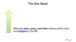
- 7. 7 The Geo Stack Efficiently store, query, and index arbitrary points, lines and polygons in the DB
- 8. 8 The Geo Stack Platform for data analysis of peer data (trades/house value/population/sales/widgets) grouped by geo data Efficiently store, query, and index arbitrary points, lines and polygons in the DB
- 9. 9 The Geo Stack Graphical rendering of geo shapes on a map Platform for data analysis of peer data (trades/house value/population/sales/widgets) grouped by geo data Efficiently store, query, and index arbitrary points, lines and polygons in the DB
- 10. 10 The Geo Stack Application(s) to browse and manipulate all the data Graphical rendering of geo shapes on a map Platform for data analysis of peer data (trades/house value/population/sales/widgets) grouped by geo data Efficiently store, query, and index arbitrary points, lines and polygons in the DB
- 11. 11 Important: Sometimes there is NO Map • Geo stack must support geo functions WITHOUT a Map • Offline reporting • “Nightly fleet management report” • “Distributor loss by assigned area” • Compute/analytical processing • Dynamic polygon generation • Weather catastrophe simulation • Other geo-filtering as input to analytics
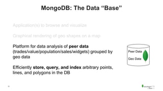
- 12. 12 MongoDB: The Data “Base” Application(s) to browse and visualize Graphical rendering of geo shapes on a map Platform for data analysis of peer data (trades/value/population/sales/widgets) grouped by geo data Efficiently store, query, and index arbitrary points, lines, and polygons in the DB Peer Data Geo Data
- 13. 13 One Persistor for All Applications & Use Cases Google Map APIs Browser / Mobile Other Javascript Peer Data Geo Data MongoDB node.js Driver MongoDB python Driver Quant / Analytics with pandas Web Service Code MongoDB Java Driver Nightly Reporting Enterprise Integration MongoDB BI Connector Tableau ClickView PowerBI Talend Mule Informatica
- 14. 14 Balanced Reporting • Most other NoSQL DBs do not have this capability • Oracle, Postgres, MySQL, SQLServer do offer it and subscribe to Open GeoS Consortium (OGC) standards
- 15. 15 MongoDB data model is the major difference MongoDB: Simple, parse-free, type-correct APIs and data to manipulate and interrogate geo shapes a.k.a. arrays (of arrays (of arrays)) OpenGIS: Piles of “ST_” functions: http://postgis.net/docs/reference.html#Geometry_Accessors SELECT ST_MakePolygon( ST_GeomFromText( 'LINESTRING(75.15 29.53,77 29,77.6 29.5, 75.15 29.53)'));
- 16. 16 Data & APIs
- 17. 17 Legacy: 2D points { name: {f: “Buzz”, l: “Moschetti”}, favoritePets: [ “dog”, “cat” ], house: [ -95.12345, 43.23423 ] }
- 18. 18 Better: GeoJSON { name: {f: “Buzz”, l: “Moschetti”}, favoritePets: [ “dog”, “cat” ], house: { type: “Point”, coordinates: [ -95.12345, 43.23423 ] } }
- 19. 19 Better: GeoJSON { name: “Superfund132”, location: { type: “Polygon”, coordinates: [ [ [-95.12345, 43.2342],[-95.12456,43.2351],…] [ [-92.8381, 43.75], … ] // “hole” ] } }
- 20. 20 The GeoJSON Family { type: “Point”, “MultiPoint”, “LineString”,”MultiLineString”, “Polygon”, “MultiPolygon” coordinates: [ specific to type ] } { type: “GeometryCollection” geometries: [ { type: (one of above), coordinates: [ . . . ] } ] NO COMPUTED SHAPES (Circle, Arc, Box, etc.) We use the WGS84 standard: http://spatialreference.org/ref/epsg/4326/
- 21. 21 MongoDB Data Types are Geo-friendly var poly = [ [ [-95.12345,43.2342],[-95.12345,43.2351], [-95.12211,43.2351],[-95.12211,43.2342], [-95.12345,43.2342] // close the loop! ] ]; db.myCollection.insert( {name: {f: "Buzz", l: "Moschetti"}, favoritePets: ["dog", "cat"], geo: { type: "Polygon“, coordinates: poly } }));
- 22. 22 … even with Java Document doc = new Document(); doc.put("name", ”Superfund132"); List ring = new ArrayList(); addPoint(ring, -95.12345, 43.2342); addPoint(ring, -95.12345, 43.2351); addPoint(ring, -95.12211, 43.2351); addPoint(ring, -95.12211, 43.2342); addPoint(ring, -95.12345, 43.2342); List poly = new ArrayList(); poly.add(ring); Map mm = new HashMap(); mm.put("type", "Polygon"); mm.put("coordinates", poly); doc.put("geo", mm); coll.insertOne(doc); static void addPoint(List ll, double lng, double lat) { List pt = new ArrayList(); pt.add(lng); pt.add(lat); ll.add(pt); }
- 23. 23 All Types Are Preserved Correctly Document doc = coll.find().first(); recursiveWalk(doc); name: java.lang.String: Superfund132 geo: com.mongodb.BasicDBObject type: java.lang.String: Polygon coordinates: com.mongodb.BasicDBList 0: com.mongodb.BasicDBList 0: com.mongodb.BasicDBList 0: java.lang.Double: -95.12345 1: java.lang.Double: 43.2342 1: com.mongodb.BasicDBList 0: java.lang.Double: -95.12345 1: java.lang.Double: 43.2351 2: com.mongodb.BasicDBList 0: java.lang.Double: -95.12211 1: java.lang.Double: 43.2351
- 24. 24 Comparison to “Good” PostGIS import org.postgis.PGgeometry; // extended from org.postgresql.util.PGobject ((org.postgresql.Connection)conn).addDataType("geometry","org.postgis.PGgeometry" ) String sql = "select geom from someTable”; ResultSet r = stmt.executeQuery(sql); while( r.next() ) { PGgeometry geom = (PGgeometry)r.getObject(1); if( geom.getType() = Geometry.POLYGON ) { Polygon pl = (Polygon)geom.getGeometry(); for( int r = 0; r < pl.numRings(); r++) { LinearRing rng = pl.getRing(r); . . . } }
- 25. 25 Comparison to most OpenGIS String sql = "select ST_AsText(geom) from someTable”; ResultSet r = stmt.executeQuery(sql); while( r.next() ) { String wkt = r.getString(1); // wkt is ”POLYGON((0 0,0 1,1 1,1 0,0 0))” // http://en.wikipedia.org/wiki/Well-known_text // Now we have to parse the string into // an array of array of doubles. // Don’t want to introduce a 3rd party dependency… // So . . . We write our own parser. }
- 26. 26 Checkpoint We have data in and out of the DB using basic operations (insert and find) Now we need to make it performant!
- 27. 27 Indexing collection.createIndex({loc:”2d”}) When to use: • Your database has legacy location data from MongoDB 2.2 or earlier • You do not intend to store any location data as GeoJSON objects • “Special Use Cases” e.g. arbitrary two numeric dimension indexing collection.createIndex({loc:”2dsphere”}) When to use: • Supports all GeoJSON objects and legacy [x,y] pairs collection.createIndex({loc:”geoHaystack”}) When to use: • Special small area flat (planar) lookup optimization
- 28. 28 Indexing collection.createIndex({loc:”2d”}) When to use: • Your database has legacy location data from MongoDB 2.2 or earlier • You do not intend to store any location data as GeoJSON objects • “Special Use Cases” e.g. arbitrary two numeric dimension indexing collection.createIndex({loc:”2dsphere”}) When to use: • Supports all GeoJSON objects and legacy [x,y] pairs collection.createIndex({loc:”geoHaystack”}) When to use: • Special small area flat (planar) lookup optimization
- 29. 29 find()/$match and Indexing Operator Geometry Arg Type 2d 2dsphere $geoWithin $box,$center,$polygon Y N $geometry: { type, coordinates } N Y $centerSphere: [ [x,y], radians ] Y Y $geoIntersects $geometry only N Y $near,$nearSphere [x,y] R - (output sorted by distance) $geometry: {type, coordinates} - R + $minDistance N Y + $maxDistance Y Y Y = will assist N = will not assist R = REQUIRED Syntax helper: find(“loc”:{$geoWithin: {$box: [ [x0,y0], [x1,y2] }}); find(“loc”:{$geoWithin: {$geometry: { type: “Polygon”, coordinates: [ …. ] }}} );
- 30. 30 Aggregation Framework: $geoNear Option 2D 2dsphere $geoNear (output sorted by distance) near: { type: “Point”, coordinates } - R - and spherical:true near: [ x, y ] R (or) R query: { expression INCL geo find() on previous page EXCEPT $near} N N Y = will assist N = will not assist R = REQUIRED Important Considerations: 1. You can only use $geoNear as the first stage of a pipeline. 2. You must include the distanceField option. 3. The collection must have only one geospatial index: one 2d index or one 2dsphere index. 4. You do not need to specify which field in the documents hold the coordinate pair or point. Because $geoNear requires that the collection have a single geospatial index, $geoNear implicitly uses the indexed field.
- 31. 31 Use Cases How do we bring data representation, fast lookup, and . . .
- 32. 32 Case #1: Find Things in a Given Area + More • Docs contain Points (or possibly “small” polygons) • $geoWithin db.site.aggregate([ {$match: { "loc": { $geoWithin: { $geometry: { type: "Polygon", coordinates: [ coords ] }}} ,"portfolio_id": portid ,“insuredValue“: {$gt: 1000000} ,“insuredDate“: {$gt: new ISODate(„2016-01-01“) }} ,{$bucket: {groupBy: „$insuredValue“, boundaries: [ 1000000, 2000000, 5000000, 10000000, 20000000, Infinity] }} . . .
- 33. 33 Case #2: Find Things in an Area Stored in DB • Get the shape from the “shapes” collection via query: db.shapes.findOne({predicate},{theShape:1}); • Turn around and query the target collection, e.g. buildingSites with shape: db.buildingSites.find({loc:{$geoWithin: theShape}})
- 34. 34 Case #3: Find Things Closest to where I am db.buildingSites.aggregate([{$geoNear: { point … }}); • Results returned already in sorted order by closeness
- 35. 35 Case #3.5: Find Things Closest to where I am but within some bounds • db.buildingSites.aggregate([ {$geoNear: { query: { “loc”: {$geoWithin: {$centerSphere: … }} } (or) query: { “loc”: {$geoWithin: {$geometry: GeoJSON }} } }} ])
- 36. 36 When the Database isn’t enough
- 37. 37 When the Database isn’t enough • VERY fast intersection/within for many objects given probes at high velocity (10000s/sec). • Geo manipulation: unions, deltas, layering • Dynamic/programmatic geo construction • Advanced features: smoothing, simplifiers, centroids, …
- 38. 38 You Need Three Things • Basic geo objects • Geo operators like intersects, within, etc. • Algos and smoothers, etc.
- 39. 39 com.vividsolutions.jts Map m = (Map) dbo.get("loc"); // get a GeoJSON object from MongoDB List coords = (List) m.get("coordinates"); List outerRing = (List) coords.get(0); // polygon is array of array of pts CoordinateSequence pseq = new CoordinateGeoJSONSequence(outerRing, true); LinearRing outerlr = new LinearRing(pseq, gf); int numHoles = coords.size() - 1; // -1 to skip outer ring; LinearRing[] holes = null; if(numHoles > 0) { holes = new LinearRing[numHoles]; for(int k = 0; k < numHoles; k++) { List innerRing = (List) coords.get(k+1); // +1 adj for outer ring CoordinateSequence psx = new CoordinateGeoJSONSequence(innerRing, true); holes[k] = new LinearRing(psx, gf); } } Polygon poly1 = new Polygon(outerlr, holes, gf); // ok if holes was null Point pt1 = new Point(pseq2, gf); boolean a = pt1.intersects(poly1); Geometry simplified = TopologyPreservingSimplifier.simplify(poly1, tolerance);
- 40. 40 The Ecosystem • OpenGeo runs over MongoDB! http://suite.opengeo.org/docs/latest/dataadmin/mongodb/index.html • BoundlessGeo: Commerical support for OpenGeo over MongoDB * Provides top 2 tiers (viz, analysis) * https://boundlessgeo.com
- 41. 41 Geo Capabilities beyond “Simple Geo”
- 42. 42 Geo as Date Range { who: ‘john’ where: ‘mongodb’ what: ‘lightning talk’ start: ISODate(“2016-06-30T15:00:00”) end: ISODate(“2016-06-30T15:05:00”) } What events were happening at 15:03? collection.find({ start : { $lte:ISODate(“2016-06-30T15:05:03”)}, end: { $gte:ISODate(“2016-06-30T15:05:03”)} })
- 43. 43 Geo as Date Range • Ranges on 2 attributes – Two BTree walks (intersection) • Assuming time can be anywhere in range of records, index walk is average 50% of index • Test: Macbook Pro, i5, 16GB RAM, data fits in WT Cache easily. Warmed up. Average of 100 runs 694ms /query using index 487ms /query – COLLSCAN!
- 44. (StartDate,EndDate) Range Type using Geo LineString “Query” longitude = t Lat=“quantized”variable 0 1 2 { who: ‘john’ where: ‘mongodb’ what: ‘lightning talk’ start: ISODate(“2016-06-30T15:00:00”) end: ISODate(“2016-06-30T15:05:00”) se_equiv: { type: “LineString”, coordinates: [[ -123.1232, 1], [-121.6253, 1]] }
- 45. 45 Over 10X performance improvement! start2 = (((start / yearsecs) - 45) *90) – 90 end2 = (((end / yearsecs) - 45) *90) – 90 event = { type: "LineString", coordinates: [ [ start2, 1 ], [end2, 1 ] ] } // dx = is the LineString “query” query = { g: { $geoIntersects: { $geometry: { type: "LineString", coordinates: [ [ dx, 0 ], [dx, 2 ] ] } } } } 45ms!
- 46. 46 Mr. Smiley db.participatingVendors.aggregate([ // Stage 1: The Bounding Box {$match: { "loc": { $geoWithin: { $geometry: { type: "Polygon", coordinates: mapBoundingBox}}} }} // Stage 2: Compute distance from Mr. Smiley to the points: Pythagorean theorem: ,{$addFields: {dist: {$sqrt: {$add: [ {$pow:[ {$subtract: [ {$arrayElemAt:[ "$loc.coordinates",0]}, mslng]} , 2]} ,{$pow:[ {$subtract:[ {$arrayElemAt:[ "$loc.coordinates", 1]}, mslat]} , 2]} ]} }}} // Stage 3: If the distance between points is LTE the sum of the radii, then // Mr. Smiley's circle intersects that of the participant: // Project 0 (no touch) or 1 (touch) ,{$addFields: {"touch": {$cond: [ {$lte: [ {$add: [ "$promoRadius", msr ]}, "$dist" ]}, 0, 1 ]}}} ,{$match: {"touch": 1}} ]); // Assume Mr. Smiley has these params: var mslng = -90.00; var mslat = 42.00; var msr = 0.005; // ~1500 ft radius around him
- 47. 47 The Pusher var pts = [ [-74.01,40.70], [-73.99,40.71], . . .]; db.foo.insert({_id:1, loc: { type:"LineString", coordinates: [ pts[0], pts[1] ]}}); // Push points onto LineString to "extend it” in an index optimized way! for(i = 2; i < pts.length; i++) { db.foo.update({_id:1},{$push: {"loc.coordinates”: pts[i]}}); // Perform other functions, e.g. c=db.foo.find({loc: {$geoIntersects: {$geometry: { type: ”Polygon", coordinates: … } } }); }
- 48. 48 Perimeter of Simple Polygon > db.foo.insert({_id:1, "poly": [ [0,0], [2,12], [4,0], [2,5], [0,0] ] }); > db.foo.insert({_id:2, "poly": [ [2,2], [5,8], [6,0], [3,1], [2,2] ] }); > db.foo.aggregate([ {$project: {"conv": {$map: { input: "$poly", as: "z", in: { x: {$arrayElemAt: ["$$z”,0]}, y: {$arrayElemAt: ["$$z”,1]} ,len: {$literal: 0} }}}}} ,{$addFields: {first: {$arrayElemAt: [ "$conv", 0 ]} }} ,{$project: {"qqq": {$reduce: { input: "$conv", initialValue: "$first", in: { x: "$$this.x”, y: "$$this.y" ,len: {$add: ["$$value.len", // len = oldlen + newLen {$sqrt: {$add: [ {$pow:[ {$subtract:["$$value.x","$$this.x"]}, 2]} ,{$pow:[ {$subtract:["$$value.y","$$this.y"]}, 2]} ] }} ] } }} ,{$project: {"len": "$qqq.len"}} { "_id" : 1, “len" : 35.10137973546188 } { "_id" : 2, "len" : 19.346952903339393 }
- 49. 49 Geospatial = 2D Numeric Indexable Space Find all branches close to my location: target = [ someLatitude, someLongitude ]; radians = 10 / 3963.2; // 10 miles db.coll.find({"location": { $geoWithin : { $center : [ target, radians ] }}}); Find nearest investments on efficient frontier: target = [ risk, reward ]; closeness = someFunction(risk, reward); db.coll.find({”investmentValue": { $geoWithin : { $center : [ target, closeness]}}});
- 50. 50 Basic Tips & Tricks • We use [long,lat], not [lat,long] like Google Maps • Use 2dsphere for geo; avoid legacy $box/$circle/$polygon • Use 2d for true 2d numeric hacks • 5 digits beyond decimal is accurate to 1.1m: • var loc = [ -92.12345, 42.56789] // FINE • var loc = [ -92.123459261145, 42.567891378902] // ABSURD • $geoWithin and $geoIntersects do not REQUIRE index • Remember to close loops (it’s GeoJSON!)
- 51. 51 esri-related Tips & Tricks • Shapefiles are everywhere; google shapefile <whatever> • Crack shapefiles to GeoJSON with python pyshp module import shapefile import sys from json import dumps reader = shapefile.Reader(sys.argv[1]) field_names = [field[0] for field in reader.fields[1:] ] buffer = [] for sr in reader.shapeRecords(): buffer.append(dict(geometry=sr.shape.__geo_interface__, properties=dict(zip(field_names, sr.record)))) sys.stdout.write(dumps({"type": "FeatureCollection”, "features": buffer}, indent=2) + "n”)
- 52. Q & A
- 53. Thank You! Buzz Moschetti Enterprise Architect [email protected] @buzzmoschetti
- 54. 54 Agenda • What does geospatial capabilities mean? • The "levels": DB with geo types, rendering, analytics • MongoDB brings together geo AND non-geo data • Geo Data model • GeoJSON • Combining GeoJSON with non-geo data • APIs and Use Cases • Looking up things contained in a polygon • Finding things near a point • Summary of geo ops e.g. $center • $geoNear and the agg framework • The power of the document model and MongoDB APIs • Arrays and rich shapes as first class types • Comparison to Postgres (PostGIS) Indexing • Geospatial queries do not necessarily require an index • 2d vs. 2dsphere • Geo stacks and the Ecosystem • MongoDB and OpenGIS and OpenGEO • Google Maps • MEAN • A Sampling of Geo Solutions • Mr. Smiley, etc. • Integration with esri and shapefiles • esri shapefile cracking
- 55. 55 Clever Hacks • John Page date thing • Mr. Smiley • Wildfire • Push pts on a LineString and check for intersects • Perimeter & Area of simple polygon • makeNgon
- 56. 56 MongoDB handles your data + geo Google handles the maps Our Drivers Google Map APIs Chrome Other Javascript Your Data GeoJSON • Organization unit is document, then collection • Geo data can contain arbitrary peer data or higher scope within doc • Proper handling of int, long, double, and decimal128 • Dates are REAL datetimes • Uniform indexability and querability across geo and “regular” data Your Server-side code