Location Analytics - Real-Time Geofencing using Kafka
1 like•1,042 views

The document discusses geofencing technology and its applications, particularly in real-time location analytics using Apache Kafka and KSQL. It outlines various use cases such as transportation management, retail guidance, and property security, alongside a detailed explanation of geofencing implementation with examples and code snippets. Additionally, it covers advanced concepts like geo-hashing and custom user-defined functions to enhance geofencing capabilities.


![3) Geofences aggregated in one group
• CREATE STREAM a03_geo_fence_status_s
• AS
• SELECT vehp.id, vehp.latitude, vehp.longitude,
geo_fence_bulk(vehp.latitude, vehp.longitude,
geofaggid_geometry_wkt_list) AS geofence_status
• FROM a03_vehicle_position_by_group_s vehp
• LEFT JOIN a03_geo_fence_aggby_group_t geofagg
• ON vehp.group_id = geofagg.group_id;
ksql> SELECT * FROM a03_geo_fence_status_s;
46 | 52.47546 | 13.34851 | [1:OUTSIDE, 3:INSIDE]
46 | 52.47521 | 13.34881 | [1:OUTSIDE, 3:INSIDE]
...
As many as there are geo-fences](https://image.slidesharecdn.com/geo-analytics-with-kafka-v1-190925093725/85/Location-Analytics-Real-Time-Geofencing-using-Kafka-19-320.jpg)
![Geo Hash Custom UDF
ksql> SELECT latitude, longitude, geo_hash(latitude, longitude, 3)
>FROM test_geo_udf_s;
38.484769753492536 | -90.23345947265625 | 9yz
public String geohash(final double latitude,
final double longitude, int length)
public List<String> neighbours(String geohash)
public String adjacentHash(String geohash, String directionString)
public List<String> coverBoundingBox(String geometryWKT, int length)
ksql> SELECT geometry_wkt, geo_hash(geometry_wkt, 5)
>FROM test_geo_udf_s;
POLYGON ((-90.23345947265625 38.484769753492536, -90.25886535644531
38.47455675836861, ...)) | [9yzf6, 9yzf7, 9yzfd, 9yzfe, 9yzff, 9yzfg, 9yzfk,
9yzfs, 9yzfu]](https://image.slidesharecdn.com/geo-analytics-with-kafka-v1-190925093725/85/Location-Analytics-Real-Time-Geofencing-using-Kafka-21-320.jpg)

![4) Geofences aggregated by GeoHash
CREATE STREAM a04_geo_fence_by_geohash_s
AS
SELECT geo_hash(geometry_wkt, 3)[0] geo_hash, id, name, geometry_wkt
FROM a04_geo_fence_s
PARTITION by geo_hash;
INSERT INTO a04_geo_fence_by_geohash_s
SELECT geo_hash(geometry_wkt, 3)[1] geo_hash, id, name, geometry_wkt
FROM a04_geo_fence_s
WHERE geo_hash(geometry_wkt, 3)[1] IS NOT NULL
PARTITION BY geo_hash;s
INSERT INTO a04_geo_fence_by_geohash_s
SELECT ...
There is no explode()
functionality in KSQL! https://github.com/confluentinc/ksql/issues/527](https://image.slidesharecdn.com/geo-analytics-with-kafka-v1-190925093725/85/Location-Analytics-Real-Time-Geofencing-using-Kafka-23-320.jpg)

![4) Geofences aggregated by GeoHash
CREATE STREAM a04_geo_fence_status_s
AS
SELECT vp.geo_hash, vp.id, vp.latitude, vp.longitude,
geo_fence_bulk (vp.latitude, vp.longitude, gf.id_geometry_wkt_list)
AS fence_status
FROM a04_vehicle_position_by_geohash_s vp
LEFT JOIN a04_geo_fence_by_geohash_t gf
ON (vp.geo_hash = gf.geo_hash);
ksql> SELECT * FROM a04_geo_fence_status_s;
u33 | 46 | 52.3906 | 13.1599 | [3:OUTSIDE]
u33 | 46 | 52.3906 | 13.1599 | [3:OUTSIDE]
9yz | 12 | 38.34409 | -90.15034 | [2:OUTSIDE, 1:OUTSIDE]
...
As many as there are geo-fences in
geohash](https://image.slidesharecdn.com/geo-analytics-with-kafka-v1-190925093725/85/Location-Analytics-Real-Time-Geofencing-using-Kafka-25-320.jpg)


![4b) Geofences aggregated by GeoHash
CREATE STREAM a04b_geofence_udf_status_s
AS
SELECT id, latitude, longitude, id_list[0] AS geofence_id,
geo_fence(latitude, longitude, geometry_wkt_list[0]) AS geofence_status
FROM a04_vehicle_position_by_geohash_s vp
LEFT JOIN a04_geo_fence_by_geohash_t gf
ON (vp.geo_hash = gf.geo_hash);
INSERT INTO a04b_geofence_udf_status_s
SELECT id, latitude, longitude, id_list[1] geofence_id,
geo_fence(latitude, longitude, geometry_wkt_list[1]) AS geofence_status
FROM a04_vehicle_position_by_geohash_s vp
LEFT JOIN a04_geo_fence_by_geohash_t gf
ON (vp.geo_hash = gf.geo_hash)
WHERE id_list[1] IS NOT NULL;](https://image.slidesharecdn.com/geo-analytics-with-kafka-v1-190925093725/85/Location-Analytics-Real-Time-Geofencing-using-Kafka-28-320.jpg)


![Geo-Fencing with Kafka Streams and Global KTable
Enrich Position with GeoHash
& Join with Geofences
Global
KTable
{ "geohash":u33", "name":"Potsdam",
"geometry_wkt":"POLYGON ((5.668945
51.416016, …))",
"last_update":1560607149015}
{"vehicle_id":10", "name":"Berlin",
"geometry_wkt":"POLYGON ((-
90.23345947265625
38.484769753492536,…))",
"last_update":1560607149015}
geofence
KTable
vehicle
position
{ "geohash":u33", "name":"Potsdam",
"geometry_wkt":"POLYGON ((5.668945
51.416016, …))",
"last_update":1560607149015}
{ "group":u33", "name":"Berlin",
"geometry_wkt":"POLYGON ((-
90.23345947265625
38.484769753492536,…))",
"last_update":1560607149015}
Enricht and Group
by GeoHash
matched
geofences
Detect Geo
Event
geofece_sa
tus
high low
low high
low high
Scalable
Latency
"Code Smell"
medium
medium
medium
geofence
by geohash
{"id":"10", "latitude" : 52.3924,
"longitude" : 13.0514, [
{"name":"Berlin"} ] }
{ "geohash":"u33", "id" : "10", "latitude" : 52.3924, "longitude" : 13.0514}
{"id":"10", "status" : "ENTER", "geofenceName":"Berlin"} }
position &
geohash](https://image.slidesharecdn.com/geo-analytics-with-kafka-v1-190925093725/85/Location-Analytics-Real-Time-Geofencing-using-Kafka-31-320.jpg)
![Geo-Fencing with Kafka Streams and Global KTable
KStream<String, GeoFence> geoFence = builder.stream(GEO_FENCE);
KStream<String, GeoFence> geoFenceByGeoHash =
geoFence.map((k,v) -> KeyValue.<GeoFence, List<String>> pair(v,
GeoHashUtil.coverBoundingBox(v.getWkt().toString(), 5)))
.flatMapValues(v -> v)
.map((k,v) -> KeyValue.<String,GeoFence>pair(v, createFrom(k, v)));
KTable<String, GeoFenceList> geofencesByGeohash =
geoFenceByGeoHash.groupByKey().aggregate(
() -> new GeoFenceList(new ArrayList<GeoFenceItem>()),
(aggKey, newValue, aggValue) -> {
GeoFenceItem geoFenceItem = new
GeoFenceItem(newValue.getId(), newValue.getName(),
newValue.getWkt(), "");
if (!aggValue.getGeoFences().contains(geoFenceItem))
aggValue.getGeoFences().add(geoFenceItem);
return aggValue;
},
Materialized.<String, GeoFenceList,
KeyValueStore<Bytes,byte[]>>as("geofences-by-geohash-store"));
geofencesByGeohash.toStream().to(GEO_FENCES_KEYEDBY_GEOHASH,
Produced.<String, GeoFenceList> keySerde(stringSerde));](https://image.slidesharecdn.com/geo-analytics-with-kafka-v1-190925093725/85/Location-Analytics-Real-Time-Geofencing-using-Kafka-32-320.jpg)


![Tile38 – How does it work?
> SETCHAN berlin WITHIN vehicle FENCE OBJECT
{"type":"Polygon","coordinates":[[[13.297920227050781,52.56195151687443],[1
3.2440185546875,52.530216577830124],[13.267364501953125,52.45998421679598],
[13.35113525390625,52.44826791583386],[13.405036926269531,52.44952338289473
],[13.501167297363281,52.47148826410652], ...]]}
> SUBSCRIBE berlin
{"ok":true,"command":"subscribe","channel":"berlin","num":1,"elapsed":"5.85
µs"}
.
.
.
{"command":"set","group":"5d07581689807d000193ac33","detect":"outside","hoo
k":"berlin","key":"vehicle","time":"2019-06-
17T09:06:30.624923584Z","id":"10","object":{"type":"Point","coordinates":[1
3.3096,52.4497]}}
SET vehicle 10 POINT 52.4497 13.3096](https://image.slidesharecdn.com/geo-analytics-with-kafka-v1-190925093725/85/Location-Analytics-Real-Time-Geofencing-using-Kafka-37-320.jpg)
![Tile38 – How does it work?
> SETHOOK berlin_hook kafka://broker-1:9092/tile38_geofence_status WITHIN
vehicle FENCE OBJECT
{"type":"Polygon","coordinates":[[[13.297920227050781,52.56195151687443],[1
3.2440185546875,52.530216577830124],[13.267364501953125,52.45998421679598],
[13.35113525390625,52.44826791583386],[13.405036926269531,52.44952338289473
],[13.501167297363281,52.47148826410652], ...]]}
bigdata@bigdata:~$ kafkacat -b localhost -t tile38_geofence_status
% Auto-selecting Consumer mode (use -P or -C to override)
{"command":"set","group":"5d07581689807d000193ac34","detect":"outside","hoo
k":"berlin_hook","key":"vehicle","time":"2019-06-
17T09:12:00.488599119Z","id":"10","object":{"type":"Point","coordinates":[1
3.3096,52.4497]}}
SET vehicle 10 POINT 52.4497 13.3096](https://image.slidesharecdn.com/geo-analytics-with-kafka-v1-190925093725/85/Location-Analytics-Real-Time-Geofencing-using-Kafka-38-320.jpg)


Location Analytics - Real-Time Geofencing using Kafka
- 1. BASEL | BERN | BRUGG | BUCHAREST | DÜSSELDORF | FRANKFURT A.M. | FREIBURG I.BR. | GENEVA HAMBURG | COPENHAGEN | LAUSANNE | MANNHEIM | MUNICH | STUTTGART | VIENNA | ZURICH http://guidoschmutz.wordpress.com@gschmutz Location Analytics Real-Time Geofencing using Kafka Guido Schmutz
- 2. Guido Schmutz Working at Trivadis for more than 22 years Consultant, Trainer Software Architect for Java, Oracle, SOA and Big Data / Fast Data Oracle Groundbreaker Ambassador & Oracle ACE Director Head of Trivadis Architecture Board Technology Manager @ Trivadis More than 30 years of software development experience Contact: [email protected] Blog: http://guidoschmutz.wordpress.com Slideshare: http://www.slideshare.net/gschmutz Twitter: gschmutz 167th edition
- 3. Agenda 1. Introduction & Motivation 2. Using KSQL 3. Using Kafka Streams 4. Using Tile38 5. Visualization using ArcadiaData 6. Summary
- 4. Guido Schmutz Working at Trivadis for more than 22 years Oracle Groundbreaker Ambassador & Oracle ACE Director Consultant, Trainer, Software Architect for Java, AWS, Azure, Oracle Cloud, SOA and Big Data / Fast Data Platform Architect & Head of Trivadis Architecture Board More than 30 years of software development experience Contact: [email protected] Blog: http://guidoschmutz.wordpress.com Slideshare: http://www.slideshare.net/gschmutz Twitter: gschmutz 155th edition
- 5. Introduction
- 6. Geofencing – What is it? • the use of GPS or RFID technology to create a virtual geographic boundary, enabling software to trigger a response when a object/device enters or leaves a particular area • Possible Events • OUTSIDE • lNSIDE • ENTER • EXIT Source: https://tile38.com
- 7. Geofencing – What can we do with it? • On-Demand and Delivery Services - assign orders to an area's designated service provider • On-Demand Transportation - track Electronic Transportation Devices and their distance from charging stations • Transportation Management - track flow of people using public transport systems • Commercial Real Estate - Identify how many people drive or walk by a specific location • Retail Shopper Guidance - Guide customer to a specific product once they are in your store • Property Security - Open or lock doors as individuals with designated devices approach or leave a building or vehicle. • Property Control - restrict vehicles to be operational only inside a geofenced area – like drones or construction equipment
- 8. Geo-Processing • Well-known text (WKT) is a text markup language for representing vector geometry objects on a map • GeoTools is a free software GIS toolkit for developing standards compliant solutions
- 9. Apache Kafka – A Streaming Platform Source Connector Sink Connector trucking_ driver KSQL Engine Kafka Streams Kafka Broker
- 10. Dash board High Level Overview of Use Case geofence Join Position & Geofences Vehicle Position object position pos & geofences Geo fencing geofence status key=10 { "id" : "10", "latitude" : 38.35821, "longitude" : -90.15311} key=3 {"id":3,"name":"Berlin, Germany","geometry_wkt":"POLYGON ((13.297920227050781 52.56195151687443, …))","last_update":1560607149015} Geofence Mgmt Vehicle Position Weather Service
- 11. Using KSQL
- 12. KSQL – Streams and Tabless geofence Table vehicle position Stream CREATE STREAM vehicle_position_s (id VARCHAR, latitude DOUBLE, longitude DOUBLE) WITH (KAFKA_TOPIC='vehicle_position', VALUE_FORMAT='DELIMITED'); CREATE TABLE geo_fence_t (id BIGINT, name VARCHAR, geometry_wkt VARCHAR) WITH (KAFKA_TOPIC='geo_fence', VALUE_FORMAT='JSON', KEY = 'id');KSQL Geofencing
- 13. How to determine "inside" or "outside" geofence? Only one standard UDF for geo processing in KSQL: GEO_DISTANCE Implement custom UDF using functionality from GeoTools Java library public String geo_fence(final double latitude, final double longitude, final String geometryWKT){ .. } public List<String> geo_fence_bulk(final double latitude , final double longitude, List<String> idGeometryListWKT) { .. } ksql> SELECT geo_fence(latitude, longitude, ' POLYGON ((13.297920227050781 52.56195151687443, 13.2440185546875 52.530216577830124, ...))') FROM test_geo_udf_s; 52.4497 | 13.3096 | OUTSIDE 52.4556 | 13.3178 | INSIDE
- 14. Custom UDF to determine if Point is inside a geometry @Udf(description = "determines if a lat/long is inside or outside the geometry passed as the 3rd parameter as WKT encoded ...") public String geo_fence(final double latitude, final double longitude, final String geometryWKT) { String status = ""; GeometryFactory geometryFactory = JTSFactoryFinder.getGeometryFactory(); WKTReader reader = new WKTReader(geometryFactory); Polygon polygon = (Polygon) reader.read(geometryWKT); Coordinate coord = new Coordinate(longitude, latitude); Point point = geometryFactory.createPoint(coord); if (point.within(polygon)) { status = "INSIDE"; } else { status = "OUTSIDE"; } return status; }
- 15. 1) Using Cross Join geofence Table Join Position & Geofences vehicle position Stream Stream pos & geofences CREATE STREAM vp_join_gf_s AS SELECT vp.id, vp.latitude, vp.longitude, gf.geometry_wkt FROM vehicle_position_s AS vp CROSS JOIN geo_fence_t AS gf There is no Cross Join in KSQL!
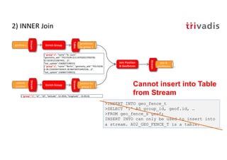
- 16. 2) INNER Join geofence Stream Join Position & Geofences vehicle position Stream Stream pos & geofences { "group":1", "name":"St. Louis", "geometry_wkt":"POLYGON ((13.297920227050781 52.56195151687443, …))", "last_update":1560607149015} { "group":1", "name":"Berlin", "geometry_wkt":"POLYGON ((-90.23345947265625 38.484769753492536,…))", "last_update":1560607149015} Enrich Group Table geofences by group 1 Enrich Group Stream postion by group 1 Cannot insert into Table from Stream >INSERT INTO geo_fence_t >SELECT '1' AS group_id, geof.id, … >FROM geo_fence_s geof; INSERT INTO can only be used to insert into a stream. A02_GEO_FENCE_T is a table. { "group":"1", "id" : "10", "latitude" : 52.3924, "longitude" : 13.0514}
- 17. 3) Geofences aggregated in one group Join Position & Geofences Stream geofence status Geofences aggby group Table { "group":1", "name":"St. Louis", "geometry_wkt":"POLYGON ((13.297920227050781 52.56195151687443, …))", "last_update":1560607149015} {"vehicle_id":10", "name":"Berlin", "geometry_wkt":"POLYGON ((-90.23345947265625 38.484769753492536,…))", "last_update":1560607149015} geo_fence_bulk geofence Stream vehicle position Stream { "group":1", "name":"St. Louis", "geometry_wkt":"POLYGON ((13.297920227050781 52.56195151687443, …))", "last_update":1560607149015} { "group":1", "name":"Berlin", "geometry_wkt":"POLYGON ((-90.23345947265625 38.484769753492536,…))", "last_update":1560607149015} Enrich With Group-1 Stream geofences by group 1 Enrich With Group-1 Stream postion by group 1 geofences by group 1 high low low high low high Scalable Latency "Code Smell" medium medium medium { "group":"1", "id" : "10", "latitude" : 52.3924, "longitude" : 13.0514}
- 18. 3) Geofences aggregated in one group CREATE TABLE a03_geo_fence_aggby_group_t AS SELECT group_id , collect_set(id + ':' + geometry_wkt) AS id_geometry_wkt_list FROM a03_geo_fence_by_group_s geof GROUP BY group_id; CREATE STREAM a03_vehicle_position_by_group_s AS SELECT '1' group_id, vehp.id, vehp.latitude, vehp.longitude FROM vehicle_position_s vehp PARTITION BY group_id;
- 19. 3) Geofences aggregated in one group • CREATE STREAM a03_geo_fence_status_s • AS • SELECT vehp.id, vehp.latitude, vehp.longitude, geo_fence_bulk(vehp.latitude, vehp.longitude, geofaggid_geometry_wkt_list) AS geofence_status • FROM a03_vehicle_position_by_group_s vehp • LEFT JOIN a03_geo_fence_aggby_group_t geofagg • ON vehp.group_id = geofagg.group_id; ksql> SELECT * FROM a03_geo_fence_status_s; 46 | 52.47546 | 13.34851 | [1:OUTSIDE, 3:INSIDE] 46 | 52.47521 | 13.34881 | [1:OUTSIDE, 3:INSIDE] ... As many as there are geo-fences
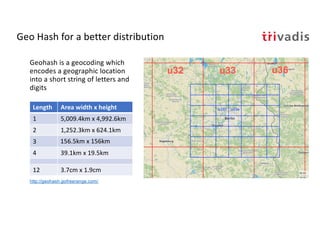
- 20. Geo Hash for a better distribution Geohash is a geocoding which encodes a geographic location into a short string of letters and digits Length Area width x height 1 5,009.4km x 4,992.6km 2 1,252.3km x 624.1km 3 156.5km x 156km 4 39.1km x 19.5km 12 3.7cm x 1.9cm http://geohash.gofreerange.com/
- 21. Geo Hash Custom UDF ksql> SELECT latitude, longitude, geo_hash(latitude, longitude, 3) >FROM test_geo_udf_s; 38.484769753492536 | -90.23345947265625 | 9yz public String geohash(final double latitude, final double longitude, int length) public List<String> neighbours(String geohash) public String adjacentHash(String geohash, String directionString) public List<String> coverBoundingBox(String geometryWKT, int length) ksql> SELECT geometry_wkt, geo_hash(geometry_wkt, 5) >FROM test_geo_udf_s; POLYGON ((-90.23345947265625 38.484769753492536, -90.25886535644531 38.47455675836861, ...)) | [9yzf6, 9yzf7, 9yzfd, 9yzfe, 9yzff, 9yzfg, 9yzfk, 9yzfs, 9yzfu]
- 22. 4) Geofences aggregated by GeoHash Join Position & Geofences Stream geofence status Geofences gpby geohash Table { "geohash":"u33", "name":"Postdam", "geometry_wkt":"POLYGON ((13.297920227050781 52.56195151687443, …))", "last_update":1560607149015} {"geohash":"u33", "name":"Berlin", "geometry_wkt":"POLYGON ((-90.23345947265625 38.484769753492536,…))", "last_update":1560607149015} geo_fence_bulk() geofence Table vehicle position Stream { "geohash":"u33", "name":"Potsam", "geometry_wkt":"POLYGON ((13.297920227050781 52.56195151687443, …))", "last_update":1560607149015} { "group":"u33", "name":"Berlin", "geometry_wkt":"POLYGON ((-90.23345947265625 38.484769753492536,…))", "last_update":1560607149015} Enrich with GeoHash Stream geofences & geohash Enrich with GeoHash Stream position & geohash geofences by geohash geo_hash() geo_hash() high low low high low high Scalable Latency "Code Smell" medium medium medium { "geohash":"u33", "id" : "10", "latitude" : 52.3924, "longitude" : 13.0514}
- 23. 4) Geofences aggregated by GeoHash CREATE STREAM a04_geo_fence_by_geohash_s AS SELECT geo_hash(geometry_wkt, 3)[0] geo_hash, id, name, geometry_wkt FROM a04_geo_fence_s PARTITION by geo_hash; INSERT INTO a04_geo_fence_by_geohash_s SELECT geo_hash(geometry_wkt, 3)[1] geo_hash, id, name, geometry_wkt FROM a04_geo_fence_s WHERE geo_hash(geometry_wkt, 3)[1] IS NOT NULL PARTITION BY geo_hash;s INSERT INTO a04_geo_fence_by_geohash_s SELECT ... There is no explode() functionality in KSQL! https://github.com/confluentinc/ksql/issues/527
- 24. 4) Geofences aggregated by GeoHash CREATE TABLE a04_geo_fence_by_geohash_t AS SELECT geo_hash, COLLECT_SET(id + ':' + geometry_wkt) AS id_geometry_wkt_list, COLLECT_SET(id) id_list FROM a04_geo_fence_by_geohash_s GROUP BY geo_hash; CREATE STREAM a04_vehicle_position_by_geohash_s AS SELECT vp.id, vp.latitude, vp.longitude, geo_hash(vp.latitude, vp.longitude, 3) geo_hash FROM vehicle_position_s vp PARTITION BY geo_hash;
- 25. 4) Geofences aggregated by GeoHash CREATE STREAM a04_geo_fence_status_s AS SELECT vp.geo_hash, vp.id, vp.latitude, vp.longitude, geo_fence_bulk (vp.latitude, vp.longitude, gf.id_geometry_wkt_list) AS fence_status FROM a04_vehicle_position_by_geohash_s vp LEFT JOIN a04_geo_fence_by_geohash_t gf ON (vp.geo_hash = gf.geo_hash); ksql> SELECT * FROM a04_geo_fence_status_s; u33 | 46 | 52.3906 | 13.1599 | [3:OUTSIDE] u33 | 46 | 52.3906 | 13.1599 | [3:OUTSIDE] 9yz | 12 | 38.34409 | -90.15034 | [2:OUTSIDE, 1:OUTSIDE] ... As many as there are geo-fences in geohash
- 26. 4a) Geofences aggregated by GeoHash Join Position & Geofences Geofences gpby geohash Table { "group":"u33", "name":" Potsdam", "geometry_wkt":"POLYGON ((5.668945 51.416016, …))", "last_update":1560607149015} {"vehicle_id":10", "name":"Berlin", "geometry_wkt":"POLYGON ((-90.23345947265625 38.484769753492536,…))", "last_update":1560607149015} geo_fence_bulk() geofence Table vehicle position Stream { "geohash":u33", "name":"Postsdam", "geometry_wkt":"POLYGON ((5.668945 51.416016, …))", "last_update":1560607149015} { "geohash":"u33", "name":"Berlin", "geometry_wkt":"POLYGON ((-90.23345947265625 38.484769753492536,…))", "last_update":1560607149015} Enrich with GeoHash Stream geofences & geohash Enrich with GeoHash Stream position & geohash geofences by geohash geo_hash() geo_hash() Stream udf status geofence status high low low high low high Scalable Latency "Code Smell" medium medium medium { "geohash":"u33", "id" : "10", "latitude" : 52.3924, "longitude" : 13.0514}
- 27. 4b) Geofences aggregated by GeoHash Join Position & Geofences Geofences gpby geohash Table { "geohash":"u33", "name":"Potsdam", "geometry_wkt":"POLYGON ((5.668945 51.416016, …))", "last_update":1560607149015} {"vehicle_id":10", "name":"Berlin", "geometry_wkt":"POLYGON ((-90.23345947265625 38.484769753492536,…))", "last_update":1560607149015} geo_fence() geofence Table vehicle position Stream { "geohash":"u33", "name":"Potsdam", "geometry_wkt":"POLYGON ((5.668945 51.416016, …))", "last_update":1560607149015} { "group":"u33", "name":"Berlin", "geometry_wkt":"POLYGON ((-90.23345947265625 38.484769753492536,…))", "last_update":1560607149015} Enrich with GeoHash Stream geofences & geohash Enrich with GeoHash Stream position & geohash geofences by geohash geo_hash() geo_hash() Stream position & geofence Explode Geofendes Stream geofence status high low low high low high Scalable Latency "Code Smell" medium medium medium { "geohash":"u33", "id" : "10", "latitude" : 52.3924, "longitude" : 13.0514}
- 28. 4b) Geofences aggregated by GeoHash CREATE STREAM a04b_geofence_udf_status_s AS SELECT id, latitude, longitude, id_list[0] AS geofence_id, geo_fence(latitude, longitude, geometry_wkt_list[0]) AS geofence_status FROM a04_vehicle_position_by_geohash_s vp LEFT JOIN a04_geo_fence_by_geohash_t gf ON (vp.geo_hash = gf.geo_hash); INSERT INTO a04b_geofence_udf_status_s SELECT id, latitude, longitude, id_list[1] geofence_id, geo_fence(latitude, longitude, geometry_wkt_list[1]) AS geofence_status FROM a04_vehicle_position_by_geohash_s vp LEFT JOIN a04_geo_fence_by_geohash_t gf ON (vp.geo_hash = gf.geo_hash) WHERE id_list[1] IS NOT NULL;
- 29. Berne Fribourg It works …. but …. • By re-partitioning by geohash we lose the guaranteed order for a given vehicle • Can be problematic, if there is a backlog in one of the topics/partitions u0m5 u0m4 u0m7 u0m6 Consumer 1 Consumer 2
- 31. Geo-Fencing with Kafka Streams and Global KTable Enrich Position with GeoHash & Join with Geofences Global KTable { "geohash":u33", "name":"Potsdam", "geometry_wkt":"POLYGON ((5.668945 51.416016, …))", "last_update":1560607149015} {"vehicle_id":10", "name":"Berlin", "geometry_wkt":"POLYGON ((- 90.23345947265625 38.484769753492536,…))", "last_update":1560607149015} geofence KTable vehicle position { "geohash":u33", "name":"Potsdam", "geometry_wkt":"POLYGON ((5.668945 51.416016, …))", "last_update":1560607149015} { "group":u33", "name":"Berlin", "geometry_wkt":"POLYGON ((- 90.23345947265625 38.484769753492536,…))", "last_update":1560607149015} Enricht and Group by GeoHash matched geofences Detect Geo Event geofece_sa tus high low low high low high Scalable Latency "Code Smell" medium medium medium geofence by geohash {"id":"10", "latitude" : 52.3924, "longitude" : 13.0514, [ {"name":"Berlin"} ] } { "geohash":"u33", "id" : "10", "latitude" : 52.3924, "longitude" : 13.0514} {"id":"10", "status" : "ENTER", "geofenceName":"Berlin"} } position & geohash
- 32. Geo-Fencing with Kafka Streams and Global KTable KStream<String, GeoFence> geoFence = builder.stream(GEO_FENCE); KStream<String, GeoFence> geoFenceByGeoHash = geoFence.map((k,v) -> KeyValue.<GeoFence, List<String>> pair(v, GeoHashUtil.coverBoundingBox(v.getWkt().toString(), 5))) .flatMapValues(v -> v) .map((k,v) -> KeyValue.<String,GeoFence>pair(v, createFrom(k, v))); KTable<String, GeoFenceList> geofencesByGeohash = geoFenceByGeoHash.groupByKey().aggregate( () -> new GeoFenceList(new ArrayList<GeoFenceItem>()), (aggKey, newValue, aggValue) -> { GeoFenceItem geoFenceItem = new GeoFenceItem(newValue.getId(), newValue.getName(), newValue.getWkt(), ""); if (!aggValue.getGeoFences().contains(geoFenceItem)) aggValue.getGeoFences().add(geoFenceItem); return aggValue; }, Materialized.<String, GeoFenceList, KeyValueStore<Bytes,byte[]>>as("geofences-by-geohash-store")); geofencesByGeohash.toStream().to(GEO_FENCES_KEYEDBY_GEOHASH, Produced.<String, GeoFenceList> keySerde(stringSerde));
- 33. Geo-Fencing with Kafka Streams and Global KTable final GlobalKTable<String, GeoFenceList> geofences = builder.globalTable(GEO_FENCES_KEYEDBY_GEOHASH); KStream<String, VehiclePositionWithMatchedGeoFences> positionWithMatchedGeoFences = vehiclePositionsWithGeoHash.leftJoin(geofences, (k, pos) -> pos.getGeohash().toString(), (pos, geofenceList) -> { List<MatchedGeoFence> matchedGeofences = new ArrayList<MatchedGeoFence>(); if(geofenceList != null) { for (GeoFenceItem geoFenceItem : geofenceList.getGeoFences()) { boolean geofenceStatus = GeoFenceUtil.geofence(pos.getLatitude(), pos.getLongitude(), geoFenceItem.getWkt().toString()); if(geofenceStatus) matchedGeofences.add(new MatchedGeoFence(geoFenceItem.getId(), geoFenceItem.getName(), null)); } } return new VehiclePositionWithMatchedGeoFences(pos.getVehicleId(), 0L, pos.getLatitude(), pos.getLongitude(), pos.getEventTime(), matchedGeofences); });
- 34. Geo-Fencing with Kafka Streams and Global KTable final KStream<String, VehiclePositionWithMatchedGeoFences> positionWithMatchedGeoFences = builder.stream(MATCHED_FENCE_STREAM); final StoreBuilder<KeyValueStore<String, VehiclePositionWithMatchedGeoFences>> vehicleGeoFenceStatusStore = Stores .keyValueStoreBuilder(Stores.persistentKeyValueStore("GeoFenceSnapshotStore"), Serdes.String(), positionWithMatchedGeoFencesSerde) .withCachingEnabled(); builder.addStateStore(bargeGeoFenceStatusStore); KStream<String, List<GeoEvent>> geoEvents = positionWithMatchedGeoFences.transformValues( () -> new GeoEventEmitter (bargeGeoFenceStatusStore.name()) ,vehicleGeoFenceStatusStore.name()); KStream<String, GeoEvent> geoEvent = geoEvents.flatMapValues(v -> v); KStream<String, GeoEvent> geoEventByVehicleId = geoEvent.selectKey((k, v) -> v.getVehicleId().toString()); geoEventByVechicleId.to(GEO_EVENT_STREAM);
- 35. Using Tile38
- 36. Tile38 • https://tile38.com • Open Source Geospatial Database & Geofencing Server • Real Time Geofencing • Roaming Geofencing • Fast Spatial Indices • Pluggable Event Notifications
- 37. Tile38 – How does it work? > SETCHAN berlin WITHIN vehicle FENCE OBJECT {"type":"Polygon","coordinates":[[[13.297920227050781,52.56195151687443],[1 3.2440185546875,52.530216577830124],[13.267364501953125,52.45998421679598], [13.35113525390625,52.44826791583386],[13.405036926269531,52.44952338289473 ],[13.501167297363281,52.47148826410652], ...]]} > SUBSCRIBE berlin {"ok":true,"command":"subscribe","channel":"berlin","num":1,"elapsed":"5.85 µs"} . . . {"command":"set","group":"5d07581689807d000193ac33","detect":"outside","hoo k":"berlin","key":"vehicle","time":"2019-06- 17T09:06:30.624923584Z","id":"10","object":{"type":"Point","coordinates":[1 3.3096,52.4497]}} SET vehicle 10 POINT 52.4497 13.3096
- 38. Tile38 – How does it work? > SETHOOK berlin_hook kafka://broker-1:9092/tile38_geofence_status WITHIN vehicle FENCE OBJECT {"type":"Polygon","coordinates":[[[13.297920227050781,52.56195151687443],[1 3.2440185546875,52.530216577830124],[13.267364501953125,52.45998421679598], [13.35113525390625,52.44826791583386],[13.405036926269531,52.44952338289473 ],[13.501167297363281,52.47148826410652], ...]]} bigdata@bigdata:~$ kafkacat -b localhost -t tile38_geofence_status % Auto-selecting Consumer mode (use -P or -C to override) {"command":"set","group":"5d07581689807d000193ac34","detect":"outside","hoo k":"berlin_hook","key":"vehicle","time":"2019-06- 17T09:12:00.488599119Z","id":"10","object":{"type":"Point","coordinates":[1 3.3096,52.4497]}} SET vehicle 10 POINT 52.4497 13.3096
- 39. 1) Enrich with GeoFences – aggregated by geohash geofence Stream vehicle position Stream Invoke UDF {"vehicle_id":10", "name":"St. Louis", "geometry_wkt":"POLYGON ((13.297920227050781 52.56195151687443, …))", "last_update":1560607149015} {"vehicle_id":10", "name":"Berlin", "geometry_wkt":"POLYGON ((- 90.23345947265625 38.484769753492536,…))", "last_update":1560607149015} { "id" : "10", "latitude" : 38.35821, "longitude" : -90.15311} Invoke UDF Geofence Service geofence status set_pos() set_fence() Stream udf status high low low high low high Scalable Latency "Code Smell" medium medium medium
- 40. 2) Using Custom Kafka Connector for Tile38 geofence vehicle position {"vehicle_id":10", "name":"St. Louis", "geometry_wkt":"POLYGON ((13.297920227050781 52.56195151687443, …))", "last_update":1560607149015} {"vehicle_id":10", "name":"Berlin", "geometry_wkt":"POLYGON ((- 90.23345947265625 38.484769753492536,…))", "last_update":1560607149015} { "id" : "10", "latitude" : 38.35821, "longitude" : -90.15311} Geofence Service kafka-to- tile38 kafka-to- tile38 geofence status high low low high low high Scalable Latency "Code Smell" medium medium medium
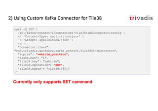
- 41. 2) Using Custom Kafka Connector for Tile38 curl -X PUT /api/kafka-connect-1/connectors/Tile38SinkConnector/config -H 'Content-Type: application/json' -H 'Accept: application/json' -d '{ "connector.class": "com.trivadis.geofence.kafka.connect.Tile38SinkConnector", "topics": "vehicle_position", "tasks.max": "1", "tile38.key": "vehicle", "tile38.operation": "SET", "tile38.hosts": "tile38:9851" }' Currently only supports SET command
- 44. Summary
- 45. Summary & Outlook • Summary • Geo Fencing is doable using Kafka and KSQL • KSQL is similar to SQL, but don't think relational • UDF and UDAF's is a powerful way to extend KSQL • Use Geo Hashes to partition work • Outlook • Performance Tests • Cleanup code of UDFs and UDAFs • Implement Kafka Source Connector for Tile 38
- 46. Technology on its own won't help you. You need to know how to use it properly.