SlideShare a Scribd company logo
Self-organization Simulation over Geographical Information System (GIS)  based on Multi-Agent Platform Presented by Anas Amjad Obeidat
Outlines Introduction Geographic Information System GIS Applications GIS Conceptual Model Layers Individual-based Model (IBM) Mixing IBM AND GIS The Chsaracteristics and Advantages of IBM Recreation Behavior Simulator (RBSim) SCHELLING'S SELF-ORGANIZED SEGREGATION MODEL Happiness Schelling's Rules Mixing Agent-based Simulation and GIS Model Support to Implement Self-organized Segregation Model Agent Analyst  General Architecture Agent-GIS Mixing after Agent Analyst Agent Analyst simulation in P2P Conclusion and Perspectives References
Introduction The challenge of the simulation of complex systems modelling based on Geographical Information System (GIS) is to propose: Future decision making supports for urban planning's or environmental. Social-politic development   Geographers manage today a great amount of geographical data and need innovative methodologies to analyse them in a applicable way.   A complex vision of the current world is strongly needed in order to face nowadays challenges in understanding, modelling and simulating The increasing of intensive communications, allowed by high technologies, leads to develop in efficient way .
Geographic Information System A geographic information system (GIS), or geographical information system, captures, stores, analyzes, manages, and presents data that is linked to location. In the strictest sense, the term describes any information system that integrates, stores, edits, analyzes, shares, and displays geographic information.  In a more generic sense, GIS applications are tools that allow users to create interactive queries (user created searches), analyze spatial information, edit data, maps, and present the results of all these operations.  Geographic Information Science is the science underlying the geographic concepts, applications and systems, taught in degree and GIS Certificate programs at many universities.
GIS Applications GIS technology can be used for  Scientific investigations Resource management Asset management Archaeology Environmental impact assessment Urban planning Cartography Criminology Geographic history Marketing Logistics Prospectively Mapping, and other purposes.  For example, GIS might allow emergency planners to easily calculate emergency response times in the event of a natural disaster, GIS might be used to find wetlands that need protection from pollution, or GIS can be used by a company to site a new business location to take advantage of a previously under-served market.
GIS Conceptual Model Layers  The actual GIS conceptual model is based on a layered structure (Goodchild et al., 1991). A layer allows gathering, in a same set, some objects corresponding to a specific thematic . Hydrological layer Building layer Road layer ...  Some new challenges for GIS future development, is to use the new conceptual models given by complexity theories to automatically identify some dynamical organizations and so to manage scenario of developments which can be used to determine automatically some social or urban re-organizations .
Individual-based Model (IBM)   IBM offers potential for studying complex system behaviours and human/landscape interactions within a spatial framework. Artificial intelligent agents introduce behaviour conditions and set communications or interactions between them and their environment as the major rule of the simulation evolution.  Agents have goals who lead their interactions or actions over the world.  Few researchers have mixed spatially explicit agents and GIS. After a non exhaustive review on that subject, we will focus our attention on Agent Analyst, based on Repast Multi-agent system.  Agent Analyst can be presented as a free extension to  ESRI's products like ArcGIS .
Mixing IBM AND GIS   The use of Individual-Based Model (IBM) is a promising approach to model spatially explicit ecological phenomena.  The successive efficient computer science concepts used for that purpose : Cellular automata theory which has demonstrated efficiency about modeling landscape dynamics by regular rules-based processes.   Object-oriented modeling (OOM) which has proved its power by representing the domain with concrete objects that have as much similarity with their real world counterparts as possible . The spatially explicit model mixed with object-based modeling lead to define the individual-based modeling (IBM).  Artificial intelligent agents (Wooldridge, 2002) introduce behavioral conditions and set communications or interactions between them and their environment as the major rule of the simulation evolution.  Agents have goals who lead their interactions or actions over their world.
The Characteristics and Advantages of IBM   A variety of types of differences among individuals in the population can be accommodated. Complex system decision making by an individual can be simulated. Local interactions in space and the effects of stochastic temporal and spatial variability are easily handled. The  first goal is to have a virtual laboratory to study the outcomes of various behavior on realistic landscapes.
Recreation Behavior Simulator (RBSim)   Itami and Gimblett have developed the Recreation Behavior Simulator (RBSim) to simulate the behavior of human individuals in natural environments . RBSim joins two computer technologies: GIS to represent environment  Autonomous Human Agents to simulate human behavior within geographic space   This tool can allow us  to investigate tourism management options. It tries to give answers to some questions like:  How different management options might affect the overall experience of tourists?  How schedule some visits and know the impact on the number and frequency of users?
(RBSim)  continue.. . Randy Gimblett develops studies about Colorado River through the Grand Canyon national park.  This natural site suffers from impacts of repeated recreational uses like campsites and the destruction of sensitive vegetation due to many visitors. A management plan has been established to protect the national resource.  RBSim is currently used to simulate the current use pattern of commercial tour operators in the Grand Canyon.  In addition, managers wish to test alternative management strategies including alternative timetables for starting trips, booking specific riverside campsites for different sized boating parties.  These strategies aimed of reducing conflicts between different boating parties, reducing environmental impact on river beaches, and increasing the number of river users.
Dynamical agents move across the landscape in RBSim (after Gimblett)
Schelling's Self-organized Segregation Model   Thomas Schelling received in October 2005, the  Nobel Price  in Economic Sciences. He contributed to enhance the understanding of conflict and cooperation about social institutions. His major work deals with game theory, he proposes a simple model of spatial segregation which can lead to self-organized phenomena.  Schelling’s city segregation model illustrates how spatial organizations can emerge from local rules, concerning the spatial distribution of people which belong to different classes.  In this model, people can move, depending on their own satisfaction to have neighbours of their  own class. Based on this model, a city can be highly segregated even if people have only a mild preference for living among people similar to them.
Schelling's  (continue…) In this model, each person is an agent placed on a 2D grid (in his original presentation, a chessboard was used by Thomas Schelling).  Each case can be considered like a house where the agent lives.  Each agent cares about the class of his immediate neighbours who are the occupants of the abutting squares of the chessboard.  Each agent has a maximum of eight possible neighbour.  Each agent has a “happiness rule” determining whether he is happy or not at his current house location. If unhappy, he either seeks an open square where his happiness rule can be satisfied or he exits the city.
Happiness Schelling's Rules  The rule-based system is described as following: An agent with only one neighbour will try to move if the neighbour is of a different class than his own. An  agent  with two neighbors will try to move unless at least one neighbor is of the same class as his own. An agent  with  from three to five neighbors will try to move unless two neighbors are of the same class as his own. An  agent  with from six to eight neighbors will try to move unless at least three neighbors are of the same class as his own.  The exact degree of segregation that emerges in the city depends strongly on the specification of the agents happiness rules
Results of Schelling's Model Computed on a Cellular Automaton
Schelling's Segregation Model Implemented by N. Gessler
Mixing Agent-based Simulation and GIS Model Support to Implement Self-organized Segregation Model Agent Analyst is an Agent-Based Modelling and Simulation (ABMS) extension for the ESRI's ArcGIS suite of products (Agent Analyst, 2006).  Agent Analysis Characteristic: Agent Analyst integrates and extends the functionalities of the open-source Repast modelling and simulation. The Recursive Porous Agent Simulation Toolkit (Repast) is an agent modelling toolkit (Repast, 2006).  It borrows many concepts from the Swarm agent-based modelling toolkit, but it  multiple pure implementations in several languages and built-in adaptive features such as genetic algorithms and regression.  Repast seeks to support the development of extremely flexible models of living social agents, but is not limited to modelling such entities.  Agent Analyst fully integrates ABMS with GIS. Through this integration, GIS experts gain the ability to model behaviours and processes as change and movement over time while ABMS modellers are able to incorporate detailed real-world environmental data, perform complex spatial processes, and study how behaviour is constrained by space and geography.  Furthermore, ABMS models can include real-time GIS data for situations such as disaster management, fire fighting, or resource management.
Agent Analyst  continue … The graphical Agent Analyst tools allow the user to create agents, schedule simulations, establish mappings to ArcGIS layers, and specify the behaviour and interactions of the agents. In the following, we will show how using Agent Analyst for Schelling's problem. A sample will be given using GIS and agent model and develop the use to implement it.  In the following, the Schelling segregation model is applied on a GIS vector layer rather than a 2D grid (Lingman-Zielinska, 2005).  The implementation is made using Agent Analyst over ArcGIS. The model is composed of two main parts.  The first one is an  environment layer of zip code regions  from a GIS and  represented in Agent Analyst by a  non movable vector GIS agent. The other part is a  set of movable generic agents , which represent the city residents who make decisions of moving to a new location (zip region).
Agent Analyst  General Architecture
Agent-GIS Mixing after Agent Analyst   The basis of the resident agent displacements come from the local rules of preference described below and a segregation phenomenon emerges from the interplay of these individual choices.  The model assumptions are based on a twofold distinction,  red  and  green  resident identity. The model is equipped with a basic parameter threshold called  tolerance , which reflects agent preference level of neighboring agents that are alike (i.e. the same “color”).  For example, if the tolerance parameter is set to 30%, then it is assumed that the agent will be satisfied if the ratio of identity-different neighboring agents to total number of neighbors does not exceed 30%. If it does, then the agent is dissatisfied and moves out to another region that is currently unoccupied.
Agent Analyst Load the City Layer Shape   in ArcMap
Schelling Model is Loaded in the ArcToolbox defined for Agent   Analyst
Agent   Analyst Actions Editor Actions editor was designed to automate the process of programming model actions. It composes all the necessary elements that constitute  an action .  Since  an action  is a method in object-oriented programming language, which is here a variant of Python, need to define its name, import the necessary classes (modules) from outside the model (if we need any), use pre-existing variables, and finally write the code for action. Once all the elements are defined, we can compile and run the model. One possible issue of the schelling model in the initial map defined previously can be represented by following figure. In this figure we have the Repast toolbar which allows managing the simulation execution.
Agent Analyst simulation
Agent Analyst simulation in P2P   Even if segregation is an important problem to manage or to control the urban systems development, the schelling model can be used and generalized to many others problems, especially for  non structured networks .  A. Singh and M. Haahr have proposed an extension of Schelling model for managing  peer to peer (P2P)  networks.  P2P is a new way of decentralized organization for communication over networks.  Because of the increasing possibilities to share and to distribute efficient computers at low cost on many position on a network, the P2P way of communication could be one of the major in the future.  The robustness of such networks in any kind of critical situations can make them powerful and efficient.
Agent Analyst simulation in P2P cont.. In an unstructured decentralized network, the location of the peers is decided randomly and therefore peers with high bandwidth may be adjacent to peers with low bandwidth introducing undesired low bottleneck bandwidth in the network.  Schelling method is based on local displacement, which change the peers connections of the considered computer over the whole connection graph.  Schelling method is also based on satisfaction criteria which is the fact that the neighbors have similar bandwidth than the considered computer.  This  demonstrate of  Schelling’s model can be used effectively for adapting P2P network topology and so to improve bandwidth usage. We can generalize this study to any kind of unstructured networks such as  mobile telecom infrastructures distribution over an urban system area.
Conclusion and Perspectives   Implementation of the Schelling's segregation model over a Geographical Information System, using mixing with Agent Based Modelling and Simulation.  Extension can be find to P2P network management but also more generally, to interaction network management.  The mixed GIS-ABMS platform is intended now to be connected to ant systems (Bertelle et al., 2006) and automata models to allow to represent evaluative negotiation processes (Ghnemat et al., 2006).  Applications to economy and urban development are well-suited to this fore coming studies.
References Agent Analyst web site (2006)  http://www.institute.redlands.edu/agentanalyst/ Aziz-Alaoui M.A. and Bertelle C. (2006) “Emergent Properties in Natural and Artificial Dynamical Systems”, Understanding Complex Systems, Springer. Bertelle, C., Dutot, A., Guinand, F. and Olivier, D. (2006)  "Organization Detection using Emergent Computing".  Int. Transactions on Systems Science and Applications ,  Special Issue  "Self-Organizing, Self-Managing Computing and Communications". Gessler, N. (2006) “”Building Complex Artificial Worlds” web site. Ghnemat, R., Oqeili, S., Bertelle, C. and Duchamp, G.H.E. (2006) “Automata-Based Adaptive Behavior for Economic Modeling Using Game Theory” in M.A. Aziz-Alaoui and C. Bertelle (eds) “Emergent Properties in Natural and Artificial Dynamic Systems”, Understanding Complex Systems, Springer. Gimblett, H.R ed. (2002) “”Integrating Geographic Information Systems and Agent-based Modeling Techniques”, Santa Fe Institute studies in the sciences of complexity, Oxford University Press. Goodchild, M.F., Rhind, D. and Maguire, D.J. (1991) “Geographical Information Systems: Principles and Applications”, Longman, New York Ligman-Zielinska, A. (2005) “Agent Analyst tutorial – Schelling GIS”, San Diego University. Repast web site (2006)  http://repast.sourceforge.net/ Singh, A. and Haar, M. (2004) “Topology adaptation in P2P Networks  using Schelling's model”, Workshop on Emergent Behavior and Distributed Computing, PPSN-VIII Wooldridge, M. (2002) “An introduction to Multi-Agent Systems”, John Wiley & Sons.

More Related Content

Viewers also liked (9)

PPTX
Military Game/Simulation Scenario/Story Development @IISTEC 2014
Marie Broyles
 
PDF
Thomas Schelling Segregation Model - An Exercise in Mapping the Dependencies ...
Daniel Katz
 
PDF
GIS and Agent-based modeling: Part 1
crooksAndrew
 
PPT
Genetic Algorithms
anas_elf
 
PDF
Agent-Based Modeling & Python @ PyData DC 2016
Jacqueline Kazil
 
PPTX
Applications of simulation in Business with Example
Pratima Ray
 
PPT
Chp. 2 simulation examples
Pravesh Negi
 
PPTX
Modelling and simulation
stjulians school
 
PPT
Simulation Powerpoint- Lecture Notes
Kesavartinii Bala Krisnain
 
Military Game/Simulation Scenario/Story Development @IISTEC 2014
Marie Broyles
 
Thomas Schelling Segregation Model - An Exercise in Mapping the Dependencies ...
Daniel Katz
 
GIS and Agent-based modeling: Part 1
crooksAndrew
 
Genetic Algorithms
anas_elf
 
Agent-Based Modeling & Python @ PyData DC 2016
Jacqueline Kazil
 
Applications of simulation in Business with Example
Pratima Ray
 
Chp. 2 simulation examples
Pravesh Negi
 
Modelling and simulation
stjulians school
 
Simulation Powerpoint- Lecture Notes
Kesavartinii Bala Krisnain
 

Similar to Self Organization Simulation Over Gis Based On Multi Agent Platform (20)

PPT
GIS Lecture Note.ppt
warkisafile1
 
DOCX
Gis
bacalan
 
PDF
Geographic information systems (gis) for libraries
Seti Keshmiripour
 
PPT
Gis basic-2
RJRANJEET1
 
PDF
GIS and Remote Sensing Training at Pitney Bowes Software
Nishant Sinha
 
PPT
Netspeed-GIS (1).ppt
Rajashekhar L
 
PPTX
Geographic Information Systems (GIS).pptx
EllenGracePorras
 
PDF
gis.pdf
RamMishra65
 
PDF
Principles of GIS unit 1
SanjanaKhemka1
 
PDF
Mike Goodchild's keynote - GISRUK 2010
GISRUK conference
 
PDF
Basic Gis
esambale
 
PPTX
A Journey to the World of GIS
Nishant Sinha
 
PDF
ch1
amani abbaas
 
PPTX
Introduction to Geographic Information System.pptx
ElijahEmmanuel6
 
PDF
GIS in Civil Engineering
abhishek chougule
 
PPTX
Introduction to GIS and its Applications.pptx
alphamale15
 
PDF
URISA’s GIS Management Institute
Greg Babinski
 
PPT
Research Areas In Geomatics
Arup Dasgupta
 
PDF
Iirs - Overview of GIS
Tushar Dholakia
 
PDF
GIS Application Used in Urban Planning In India
IRJET Journal
 
GIS Lecture Note.ppt
warkisafile1
 
Gis
bacalan
 
Geographic information systems (gis) for libraries
Seti Keshmiripour
 
Gis basic-2
RJRANJEET1
 
GIS and Remote Sensing Training at Pitney Bowes Software
Nishant Sinha
 
Netspeed-GIS (1).ppt
Rajashekhar L
 
Geographic Information Systems (GIS).pptx
EllenGracePorras
 
gis.pdf
RamMishra65
 
Principles of GIS unit 1
SanjanaKhemka1
 
Mike Goodchild's keynote - GISRUK 2010
GISRUK conference
 
Basic Gis
esambale
 
A Journey to the World of GIS
Nishant Sinha
 
Introduction to Geographic Information System.pptx
ElijahEmmanuel6
 
GIS in Civil Engineering
abhishek chougule
 
Introduction to GIS and its Applications.pptx
alphamale15
 
URISA’s GIS Management Institute
Greg Babinski
 
Research Areas In Geomatics
Arup Dasgupta
 
Iirs - Overview of GIS
Tushar Dholakia
 
GIS Application Used in Urban Planning In India
IRJET Journal
 
Ad

Recently uploaded (20)

PPTX
Extensions Framework (XaaS) - Enabling Orchestrate Anything
ShapeBlue
 
PPT
Interview paper part 3, It is based on Interview Prep
SoumyadeepGhosh39
 
PDF
CloudStack GPU Integration - Rohit Yadav
ShapeBlue
 
PDF
How Startups Are Growing Faster with App Developers in Australia.pdf
India App Developer
 
PDF
Rethinking Security Operations - SOC Evolution Journey.pdf
Haris Chughtai
 
PDF
Predicting the unpredictable: re-engineering recommendation algorithms for fr...
Speck&Tech
 
PDF
Log-Based Anomaly Detection: Enhancing System Reliability with Machine Learning
Mohammed BEKKOUCHE
 
PDF
LLMs.txt: Easily Control How AI Crawls Your Site
Keploy
 
PDF
SWEBOK Guide and Software Services Engineering Education
Hironori Washizaki
 
PPTX
✨Unleashing Collaboration: Salesforce Channels & Community Power in Patna!✨
SanjeetMishra29
 
PDF
Human-centred design in online workplace learning and relationship to engagem...
Tracy Tang
 
PDF
Building Resilience with Digital Twins : Lessons from Korea
SANGHEE SHIN
 
PDF
Français Patch Tuesday - Juillet
Ivanti
 
PPTX
Building Search Using OpenSearch: Limitations and Workarounds
Sease
 
PPTX
Top Managed Service Providers in Los Angeles
Captain IT
 
PDF
HCIP-Data Center Facility Deployment V2.0 Training Material (Without Remarks ...
mcastillo49
 
PDF
Smart Air Quality Monitoring with Serrax AQM190 LITE
SERRAX TECHNOLOGIES LLP
 
PPTX
Building and Operating a Private Cloud with CloudStack and LINBIT CloudStack ...
ShapeBlue
 
PDF
TrustArc Webinar - Data Privacy Trends 2025: Mid-Year Insights & Program Stra...
TrustArc
 
PDF
Persuasive AI: risks and opportunities in the age of digital debate
Speck&Tech
 
Extensions Framework (XaaS) - Enabling Orchestrate Anything
ShapeBlue
 
Interview paper part 3, It is based on Interview Prep
SoumyadeepGhosh39
 
CloudStack GPU Integration - Rohit Yadav
ShapeBlue
 
How Startups Are Growing Faster with App Developers in Australia.pdf
India App Developer
 
Rethinking Security Operations - SOC Evolution Journey.pdf
Haris Chughtai
 
Predicting the unpredictable: re-engineering recommendation algorithms for fr...
Speck&Tech
 
Log-Based Anomaly Detection: Enhancing System Reliability with Machine Learning
Mohammed BEKKOUCHE
 
LLMs.txt: Easily Control How AI Crawls Your Site
Keploy
 
SWEBOK Guide and Software Services Engineering Education
Hironori Washizaki
 
✨Unleashing Collaboration: Salesforce Channels & Community Power in Patna!✨
SanjeetMishra29
 
Human-centred design in online workplace learning and relationship to engagem...
Tracy Tang
 
Building Resilience with Digital Twins : Lessons from Korea
SANGHEE SHIN
 
Français Patch Tuesday - Juillet
Ivanti
 
Building Search Using OpenSearch: Limitations and Workarounds
Sease
 
Top Managed Service Providers in Los Angeles
Captain IT
 
HCIP-Data Center Facility Deployment V2.0 Training Material (Without Remarks ...
mcastillo49
 
Smart Air Quality Monitoring with Serrax AQM190 LITE
SERRAX TECHNOLOGIES LLP
 
Building and Operating a Private Cloud with CloudStack and LINBIT CloudStack ...
ShapeBlue
 
TrustArc Webinar - Data Privacy Trends 2025: Mid-Year Insights & Program Stra...
TrustArc
 
Persuasive AI: risks and opportunities in the age of digital debate
Speck&Tech
 
Ad

Self Organization Simulation Over Gis Based On Multi Agent Platform

  • 1. Self-organization Simulation over Geographical Information System (GIS) based on Multi-Agent Platform Presented by Anas Amjad Obeidat
  • 2. Outlines Introduction Geographic Information System GIS Applications GIS Conceptual Model Layers Individual-based Model (IBM) Mixing IBM AND GIS The Chsaracteristics and Advantages of IBM Recreation Behavior Simulator (RBSim) SCHELLING'S SELF-ORGANIZED SEGREGATION MODEL Happiness Schelling's Rules Mixing Agent-based Simulation and GIS Model Support to Implement Self-organized Segregation Model Agent Analyst General Architecture Agent-GIS Mixing after Agent Analyst Agent Analyst simulation in P2P Conclusion and Perspectives References
  • 3. Introduction The challenge of the simulation of complex systems modelling based on Geographical Information System (GIS) is to propose: Future decision making supports for urban planning's or environmental. Social-politic development Geographers manage today a great amount of geographical data and need innovative methodologies to analyse them in a applicable way. A complex vision of the current world is strongly needed in order to face nowadays challenges in understanding, modelling and simulating The increasing of intensive communications, allowed by high technologies, leads to develop in efficient way .
  • 4. Geographic Information System A geographic information system (GIS), or geographical information system, captures, stores, analyzes, manages, and presents data that is linked to location. In the strictest sense, the term describes any information system that integrates, stores, edits, analyzes, shares, and displays geographic information. In a more generic sense, GIS applications are tools that allow users to create interactive queries (user created searches), analyze spatial information, edit data, maps, and present the results of all these operations. Geographic Information Science is the science underlying the geographic concepts, applications and systems, taught in degree and GIS Certificate programs at many universities.
  • 5. GIS Applications GIS technology can be used for Scientific investigations Resource management Asset management Archaeology Environmental impact assessment Urban planning Cartography Criminology Geographic history Marketing Logistics Prospectively Mapping, and other purposes. For example, GIS might allow emergency planners to easily calculate emergency response times in the event of a natural disaster, GIS might be used to find wetlands that need protection from pollution, or GIS can be used by a company to site a new business location to take advantage of a previously under-served market.
  • 6. GIS Conceptual Model Layers The actual GIS conceptual model is based on a layered structure (Goodchild et al., 1991). A layer allows gathering, in a same set, some objects corresponding to a specific thematic . Hydrological layer Building layer Road layer ... Some new challenges for GIS future development, is to use the new conceptual models given by complexity theories to automatically identify some dynamical organizations and so to manage scenario of developments which can be used to determine automatically some social or urban re-organizations .
  • 7. Individual-based Model (IBM) IBM offers potential for studying complex system behaviours and human/landscape interactions within a spatial framework. Artificial intelligent agents introduce behaviour conditions and set communications or interactions between them and their environment as the major rule of the simulation evolution. Agents have goals who lead their interactions or actions over the world. Few researchers have mixed spatially explicit agents and GIS. After a non exhaustive review on that subject, we will focus our attention on Agent Analyst, based on Repast Multi-agent system. Agent Analyst can be presented as a free extension to ESRI's products like ArcGIS .
  • 8. Mixing IBM AND GIS The use of Individual-Based Model (IBM) is a promising approach to model spatially explicit ecological phenomena. The successive efficient computer science concepts used for that purpose : Cellular automata theory which has demonstrated efficiency about modeling landscape dynamics by regular rules-based processes. Object-oriented modeling (OOM) which has proved its power by representing the domain with concrete objects that have as much similarity with their real world counterparts as possible . The spatially explicit model mixed with object-based modeling lead to define the individual-based modeling (IBM). Artificial intelligent agents (Wooldridge, 2002) introduce behavioral conditions and set communications or interactions between them and their environment as the major rule of the simulation evolution. Agents have goals who lead their interactions or actions over their world.
  • 9. The Characteristics and Advantages of IBM A variety of types of differences among individuals in the population can be accommodated. Complex system decision making by an individual can be simulated. Local interactions in space and the effects of stochastic temporal and spatial variability are easily handled. The first goal is to have a virtual laboratory to study the outcomes of various behavior on realistic landscapes.
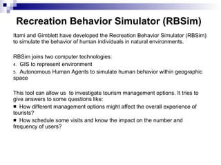
  • 10. Recreation Behavior Simulator (RBSim) Itami and Gimblett have developed the Recreation Behavior Simulator (RBSim) to simulate the behavior of human individuals in natural environments . RBSim joins two computer technologies: GIS to represent environment Autonomous Human Agents to simulate human behavior within geographic space This tool can allow us to investigate tourism management options. It tries to give answers to some questions like: How different management options might affect the overall experience of tourists? How schedule some visits and know the impact on the number and frequency of users?
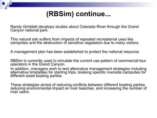
  • 11. (RBSim) continue.. . Randy Gimblett develops studies about Colorado River through the Grand Canyon national park. This natural site suffers from impacts of repeated recreational uses like campsites and the destruction of sensitive vegetation due to many visitors. A management plan has been established to protect the national resource. RBSim is currently used to simulate the current use pattern of commercial tour operators in the Grand Canyon. In addition, managers wish to test alternative management strategies including alternative timetables for starting trips, booking specific riverside campsites for different sized boating parties. These strategies aimed of reducing conflicts between different boating parties, reducing environmental impact on river beaches, and increasing the number of river users.
  • 12. Dynamical agents move across the landscape in RBSim (after Gimblett)
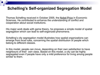
  • 13. Schelling's Self-organized Segregation Model Thomas Schelling received in October 2005, the Nobel Price in Economic Sciences. He contributed to enhance the understanding of conflict and cooperation about social institutions. His major work deals with game theory, he proposes a simple model of spatial segregation which can lead to self-organized phenomena. Schelling’s city segregation model illustrates how spatial organizations can emerge from local rules, concerning the spatial distribution of people which belong to different classes. In this model, people can move, depending on their own satisfaction to have neighbours of their own class. Based on this model, a city can be highly segregated even if people have only a mild preference for living among people similar to them.
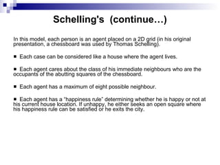
  • 14. Schelling's (continue…) In this model, each person is an agent placed on a 2D grid (in his original presentation, a chessboard was used by Thomas Schelling). Each case can be considered like a house where the agent lives. Each agent cares about the class of his immediate neighbours who are the occupants of the abutting squares of the chessboard. Each agent has a maximum of eight possible neighbour. Each agent has a “happiness rule” determining whether he is happy or not at his current house location. If unhappy, he either seeks an open square where his happiness rule can be satisfied or he exits the city.
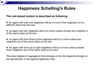
  • 15. Happiness Schelling's Rules The rule-based system is described as following: An agent with only one neighbour will try to move if the neighbour is of a different class than his own. An agent with two neighbors will try to move unless at least one neighbor is of the same class as his own. An agent with from three to five neighbors will try to move unless two neighbors are of the same class as his own. An agent with from six to eight neighbors will try to move unless at least three neighbors are of the same class as his own. The exact degree of segregation that emerges in the city depends strongly on the specification of the agents happiness rules
  • 16. Results of Schelling's Model Computed on a Cellular Automaton
  • 17. Schelling's Segregation Model Implemented by N. Gessler
  • 18. Mixing Agent-based Simulation and GIS Model Support to Implement Self-organized Segregation Model Agent Analyst is an Agent-Based Modelling and Simulation (ABMS) extension for the ESRI's ArcGIS suite of products (Agent Analyst, 2006). Agent Analysis Characteristic: Agent Analyst integrates and extends the functionalities of the open-source Repast modelling and simulation. The Recursive Porous Agent Simulation Toolkit (Repast) is an agent modelling toolkit (Repast, 2006). It borrows many concepts from the Swarm agent-based modelling toolkit, but it multiple pure implementations in several languages and built-in adaptive features such as genetic algorithms and regression. Repast seeks to support the development of extremely flexible models of living social agents, but is not limited to modelling such entities. Agent Analyst fully integrates ABMS with GIS. Through this integration, GIS experts gain the ability to model behaviours and processes as change and movement over time while ABMS modellers are able to incorporate detailed real-world environmental data, perform complex spatial processes, and study how behaviour is constrained by space and geography. Furthermore, ABMS models can include real-time GIS data for situations such as disaster management, fire fighting, or resource management.
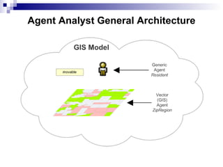
  • 19. Agent Analyst continue … The graphical Agent Analyst tools allow the user to create agents, schedule simulations, establish mappings to ArcGIS layers, and specify the behaviour and interactions of the agents. In the following, we will show how using Agent Analyst for Schelling's problem. A sample will be given using GIS and agent model and develop the use to implement it. In the following, the Schelling segregation model is applied on a GIS vector layer rather than a 2D grid (Lingman-Zielinska, 2005). The implementation is made using Agent Analyst over ArcGIS. The model is composed of two main parts. The first one is an environment layer of zip code regions from a GIS and represented in Agent Analyst by a non movable vector GIS agent. The other part is a set of movable generic agents , which represent the city residents who make decisions of moving to a new location (zip region).
  • 20. Agent Analyst General Architecture
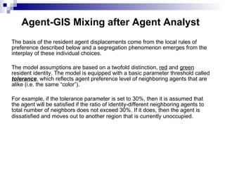
  • 21. Agent-GIS Mixing after Agent Analyst The basis of the resident agent displacements come from the local rules of preference described below and a segregation phenomenon emerges from the interplay of these individual choices. The model assumptions are based on a twofold distinction, red and green resident identity. The model is equipped with a basic parameter threshold called tolerance , which reflects agent preference level of neighboring agents that are alike (i.e. the same “color”). For example, if the tolerance parameter is set to 30%, then it is assumed that the agent will be satisfied if the ratio of identity-different neighboring agents to total number of neighbors does not exceed 30%. If it does, then the agent is dissatisfied and moves out to another region that is currently unoccupied.
  • 22. Agent Analyst Load the City Layer Shape in ArcMap
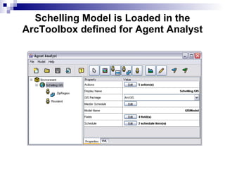
  • 23. Schelling Model is Loaded in the ArcToolbox defined for Agent Analyst
  • 24. Agent Analyst Actions Editor Actions editor was designed to automate the process of programming model actions. It composes all the necessary elements that constitute an action . Since an action is a method in object-oriented programming language, which is here a variant of Python, need to define its name, import the necessary classes (modules) from outside the model (if we need any), use pre-existing variables, and finally write the code for action. Once all the elements are defined, we can compile and run the model. One possible issue of the schelling model in the initial map defined previously can be represented by following figure. In this figure we have the Repast toolbar which allows managing the simulation execution.
  • 26. Agent Analyst simulation in P2P Even if segregation is an important problem to manage or to control the urban systems development, the schelling model can be used and generalized to many others problems, especially for non structured networks . A. Singh and M. Haahr have proposed an extension of Schelling model for managing peer to peer (P2P) networks. P2P is a new way of decentralized organization for communication over networks. Because of the increasing possibilities to share and to distribute efficient computers at low cost on many position on a network, the P2P way of communication could be one of the major in the future. The robustness of such networks in any kind of critical situations can make them powerful and efficient.
  • 27. Agent Analyst simulation in P2P cont.. In an unstructured decentralized network, the location of the peers is decided randomly and therefore peers with high bandwidth may be adjacent to peers with low bandwidth introducing undesired low bottleneck bandwidth in the network. Schelling method is based on local displacement, which change the peers connections of the considered computer over the whole connection graph. Schelling method is also based on satisfaction criteria which is the fact that the neighbors have similar bandwidth than the considered computer. This demonstrate of Schelling’s model can be used effectively for adapting P2P network topology and so to improve bandwidth usage. We can generalize this study to any kind of unstructured networks such as mobile telecom infrastructures distribution over an urban system area.
  • 28. Conclusion and Perspectives Implementation of the Schelling's segregation model over a Geographical Information System, using mixing with Agent Based Modelling and Simulation. Extension can be find to P2P network management but also more generally, to interaction network management. The mixed GIS-ABMS platform is intended now to be connected to ant systems (Bertelle et al., 2006) and automata models to allow to represent evaluative negotiation processes (Ghnemat et al., 2006). Applications to economy and urban development are well-suited to this fore coming studies.
  • 29. References Agent Analyst web site (2006) http://www.institute.redlands.edu/agentanalyst/ Aziz-Alaoui M.A. and Bertelle C. (2006) “Emergent Properties in Natural and Artificial Dynamical Systems”, Understanding Complex Systems, Springer. Bertelle, C., Dutot, A., Guinand, F. and Olivier, D. (2006) "Organization Detection using Emergent Computing". Int. Transactions on Systems Science and Applications , Special Issue "Self-Organizing, Self-Managing Computing and Communications". Gessler, N. (2006) “”Building Complex Artificial Worlds” web site. Ghnemat, R., Oqeili, S., Bertelle, C. and Duchamp, G.H.E. (2006) “Automata-Based Adaptive Behavior for Economic Modeling Using Game Theory” in M.A. Aziz-Alaoui and C. Bertelle (eds) “Emergent Properties in Natural and Artificial Dynamic Systems”, Understanding Complex Systems, Springer. Gimblett, H.R ed. (2002) “”Integrating Geographic Information Systems and Agent-based Modeling Techniques”, Santa Fe Institute studies in the sciences of complexity, Oxford University Press. Goodchild, M.F., Rhind, D. and Maguire, D.J. (1991) “Geographical Information Systems: Principles and Applications”, Longman, New York Ligman-Zielinska, A. (2005) “Agent Analyst tutorial – Schelling GIS”, San Diego University. Repast web site (2006) http://repast.sourceforge.net/ Singh, A. and Haar, M. (2004) “Topology adaptation in P2P Networks using Schelling's model”, Workshop on Emergent Behavior and Distributed Computing, PPSN-VIII Wooldridge, M. (2002) “An introduction to Multi-Agent Systems”, John Wiley & Sons.