4
Most read
5
Most read
12
Most read
Lecture 6.
Sources of errors in GNSS measurements
and dilution of precision (DOP) parameter
The position calculated by a satellite navigation receiver relies on three
measurements:
- time
- position of satellite
- range between satellite and receiver
precise time position of satellite range satellite-receiver
All measurements should be
performed in system time scale.
The clock of the receiver is out-of-
sync with the satellite’s clock (𝜏).
On-board clock of each satellite
also contains some drift (𝛿𝑡 𝑠).
Satellite’s coordinates in space are
applied in calculations of user’s
location. These coordinates are
result of ephemeris recalculation.
There is ephemeris error (𝛿𝜏 𝑒𝑝ℎ).
Receiver performs measurements
of range to navigation satellite.
All errors of this measurement
affect on accuracy of positioning.
𝑅 𝑚𝑒𝑎𝑠𝑢𝑟𝑒𝑑 = 𝑅 𝑡𝑟𝑢𝑒 + 𝑐𝜏 + 𝑐𝛿𝑡 𝑠 + 𝑐𝛿𝑡 𝑒𝑝ℎ
Further errors occur during signal propagation and in the user segment:
𝛿𝑡𝑖𝑜𝑛 − ionospheric error
𝑐𝛿𝑡𝑡𝑟𝑜𝑝 − tropospheric error
𝑐𝛿𝑡 𝑚 − multipath error
𝑐𝛿𝑡 𝑜𝑡ℎ𝑒𝑟 − other errors
These error terms also should be taken into account in the range equation.
The pseudo-distance equation
𝑅 𝑚𝑒𝑎𝑠𝑢𝑟𝑒𝑑 = 𝑅 𝑡𝑟𝑢𝑒 + 𝑐𝜏 + 𝑐𝛿𝑡 𝑠 + 𝑐𝛿𝑡 𝑒𝑝ℎ + 𝑐𝛿𝑡𝑖𝑜𝑛 + 𝑐𝛿𝑡𝑡𝑟𝑜𝑝 + 𝑐𝛿𝑡 𝑚 + 𝑐𝛿𝑡 𝑜𝑡ℎ𝑒𝑟
UERE (user equivalent range error) – difference between
true distance from a satellite to the receiver and its measured
pseudo-distance
UERE (user equivalent range error) – quantity that is obtained when we combine
receiver noise, satellite clock and ephemeris error, atmospheric error, multipath –
all expressed in units of distance.
UERE errors originate from different sources and thus are independent of each
other. The total UERE is the square root of the sum of the squares of the individual
errors.
𝜎𝑟𝑎𝑛𝑔𝑒
= 𝜎𝑖𝑜𝑛𝑜
2
+ 𝜎𝑡𝑟𝑜𝑝𝑜
2 + 𝜎𝑒𝑝ℎ𝑒𝑚
2 + 𝜎𝑐𝑙𝑜𝑐𝑘_𝑒𝑟𝑟𝑜𝑟𝑠
2 + 𝜎 𝑚𝑢𝑙𝑡𝑖𝑝𝑎𝑡ℎ
2
Satellite Clocks
The atomic clocks in the GNSS satellites are very accurate, but they do drift a small
amount. Unfortunately, a small inaccuracy in the satellite clock results in a significant
error in the position calculated by the receiver.
10−9 ∙ 3 ∙ 109 = 3 metres of position error.
The clock on the satellite is monitored by the GNSS ground control system and
compared to the even more accurate clock used in the ground control system. In the
downlink data, the satellite provides the user with an estimate of its clock offset.
Typically, the estimate has an accuracy of about ±2 meters, although the accuracy can
vary between different GNSS systems. To obtain a more accurate position, the GNSS
receiver needs to compensate for the clock error.
Orbit Errors
GNSS satellites travel in very precise, well known orbits. However the orbits do
vary a small amount. Also, like the satellite clocks, a small variation in the orbit
results in a significant error in the position calculated.
The GNSS ground control system continually monitors the satellite orbit. When the
satellite orbit changes, the ground control system sends a correction to the
satellites and the satellite ephemeris is updated. Even with the corrections from the
GNSS ground control system, there are still small errors in the orbit that can result
in up to ±2.5 meters of position error.
The ionosphere is the layer of atmosphere between 80 km and 800 km above
the earth. This layer contains electrically charged particles called ions.
These ions delay the satellite signals and can cause a significant amount
of satellite position error (typically ±5 meters,
but can be more during periods
of high ionospheric activity).
Ionospheric delay varies with solar
activity, time of year, season, time of day
and location. This makes it very difficult
to predict how much ionospheric delay
is impacting the calculated position.
Ionospheric delay
The troposphere is the layer of atmosphere closest to the surface of the Earth.
Variations in tropospheric delay are caused by the changing humidity, temperature
and atmospheric pressure in the troposphere.
Tropospheric Delay
Since tropospheric conditions are very
similar within a local area, the base station
and rover receivers experience very similar
tropospheric delay. Receivers can use
tropospheric models to estimate the amount
of error caused by tropospheric delay.
MultipathMultipath occurs when a GNSS signal is reflected off
an object, such as the wall of a building, to the GNSS
antenna. Because the reflected signal travels farther to
reach the antenna, the reflected signal arrives at the
receiver slightly delayed. This delayed signal can
cause the receiver to calculate an incorrect position.
The simplest way to reduce multipath
errors is to place the GNSS antenna in a
location that is away from the reflective
surface. When this is not possible, the
GNSS receiver and antenna must deal
with the multipath signals.
The influence of satellite geometry
The precision of positioning with GNSS navigation depends on the one hand
on the precision of individual pseudorange measurements and on the other
hand on the geometric configuration of the satellites used. This configuration
is expressed in terms of scalar value DOP (Dilution of Precision)
B range measurement
with error, green space -
area of user possible
location
A the measurement
error is the same, but
the error on their
position has grown
considerably due to the
arrangement of the
landmarks.
C the measurement error
is the same, but the error
on their position has
grown considerably due
to the arrangement of the
landmarks.
Dilution of Precision
In any ranging system, receiver-transmitter geometry influences position
precision. In (a), the position uncertainty is small (low dilution of precision).
In (b), transmitter 2 is moved closer to transmitter 1, and, although the
measurement error is the same, the position uncertainty is considerably
larger (high dilution of precision)
Sources of errors in GNSS measurements and dilution of precision (DOP) parameter (Lecture 6)

More Related Content

PPTX
GPS ERRORS
PPT
GPS-errors-1
PPTX
Errors and biases in gps
PPT
GPS-errors-2
PPT
How GPS Works
PPT
Global Positing System
PPTX
An Introduction to GNSS(Global Navigation Satellite Systems) .pptx
PPTX
GPS ERRORS
GPS-errors-1
Errors and biases in gps
GPS-errors-2
How GPS Works
Global Positing System
An Introduction to GNSS(Global Navigation Satellite Systems) .pptx

What's hot (20)

PPTX
GLOBAL POSITIONING SYSTEM
PDF
PPT
Introduction-of-GNSS-2
PPTX
Global positioning system (GPS)
PPTX
Glonass
PPT
Global Positioning system GPS - Dr. S. Balamurugan
PPT
Gps
PPT
Global Positioning System
PPT
GPS (Global Positioning System)
PPTX
How the gps system works
PPTX
Global positioning system (gps)
PDF
Introduction to GNSS (1)
PPT
Gps-signal
PPTX
Gps principle and working
PPTX
Global positioning system (gps)
PDF
PPT
Dgps seminar
PPTX
PPTX
Introduction of gps global navigation satellite systems
PPTX
Global Positioning System
GLOBAL POSITIONING SYSTEM
Introduction-of-GNSS-2
Global positioning system (GPS)
Glonass
Global Positioning system GPS - Dr. S. Balamurugan
Gps
Global Positioning System
GPS (Global Positioning System)
How the gps system works
Global positioning system (gps)
Introduction to GNSS (1)
Gps-signal
Gps principle and working
Global positioning system (gps)
Dgps seminar
Introduction of gps global navigation satellite systems
Global Positioning System
Ad

Similar to Sources of errors in GNSS measurements and dilution of precision (DOP) parameter (Lecture 6) (20)

PDF
Accuracy improvement of gnss and real time kinematic using egyptian network a...
PDF
Sources of GPS Errors in a Glance (2016)
PPTX
Critical factors affecting rtk accuracy
PDF
ANALYSIS OF GPS ERRORS DURING DIFFERENT TIMES IN A DAY
PDF
Differential gps (dgps) 09 04-12
PDF
Tower verticality for Tall Building using DGPS
DOCX
Gps final main
RTF
GPS Part Two - article
PPTX
#2 gnss errors,its sources & mitigation techniques
PPTX
Global Positioning System
PPT
PDF
Biases and Receivers (3)
PDF
Relativistic Effect in GPS Satellite and Computation of Time Error
PPTX
Errors and biasis
PPTX
Errors and biasis
PPT
The Gps Technology Paras
PPT
Global Positioning System
PPTX
term paper 2
DOCX
PDF
Global positioning system (GPS), components and its functions.pdf
Accuracy improvement of gnss and real time kinematic using egyptian network a...
Sources of GPS Errors in a Glance (2016)
Critical factors affecting rtk accuracy
ANALYSIS OF GPS ERRORS DURING DIFFERENT TIMES IN A DAY
Differential gps (dgps) 09 04-12
Tower verticality for Tall Building using DGPS
Gps final main
GPS Part Two - article
#2 gnss errors,its sources & mitigation techniques
Global Positioning System
Biases and Receivers (3)
Relativistic Effect in GPS Satellite and Computation of Time Error
Errors and biasis
Errors and biasis
The Gps Technology Paras
Global Positioning System
term paper 2
Global positioning system (GPS), components and its functions.pdf
Ad

More from Olexiy Pogurelskiy (6)

PPTX
Systems of time measurement (Lecture5)
PPTX
Theoretical background of satellite navigation systems functioning (Lecture 4)
PPT
Doc 9849 Global Navigation Satellite System
PPTX
Coordinate systems (Lecture 3)
PPTX
Keplerian orbital elements (lecture 2)
PPTX
Laws of artificial satellites motion (Lecture 1)
Systems of time measurement (Lecture5)
Theoretical background of satellite navigation systems functioning (Lecture 4)
Doc 9849 Global Navigation Satellite System
Coordinate systems (Lecture 3)
Keplerian orbital elements (lecture 2)
Laws of artificial satellites motion (Lecture 1)

Recently uploaded (20)

PPTX
PLASMA AND ITS CONSTITUENTS 123.pptx
PPTX
Neurology of Systemic disease all systems
PDF
Fun with Grammar (Communicative Activities for the Azar Grammar Series)
PPTX
Key-Features-of-the-SHS-Program-v4-Slides (3) PPT2.pptx
PPTX
ACFE CERTIFICATION TRAINING ON LAW.pptx
PDF
Health aspects of bilberry: A review on its general benefits
PPTX
Neurological complocations of systemic disease
PPTX
Power Point PR B.Inggris 12 Ed. 2019.pptx
PDF
African Communication Research: A review
PDF
0520_Scheme_of_Work_(for_examination_from_2021).pdf
PDF
Nurlina - Urban Planner Portfolio (english ver)
PPTX
Designing Adaptive Learning Paths in Virtual Learning Environments
PPTX
Why I Am A Baptist, History of the Baptist, The Baptist Distinctives, 1st Bap...
PDF
Diabetes Mellitus , types , clinical picture, investigation and managment
PDF
Everyday Spelling and Grammar by Kathi Wyldeck
PPTX
2025 High Blood Pressure Guideline Slide Set.pptx
PDF
Chevening Scholarship Application and Interview Preparation Guide
PDF
Laparoscopic Dissection Techniques at WLH
PPTX
principlesofmanagementsem1slides-131211060335-phpapp01 (1).ppt
PPT
Acidosis in Dairy Herds: Causes, Signs, Management, Prevention and Treatment
PLASMA AND ITS CONSTITUENTS 123.pptx
Neurology of Systemic disease all systems
Fun with Grammar (Communicative Activities for the Azar Grammar Series)
Key-Features-of-the-SHS-Program-v4-Slides (3) PPT2.pptx
ACFE CERTIFICATION TRAINING ON LAW.pptx
Health aspects of bilberry: A review on its general benefits
Neurological complocations of systemic disease
Power Point PR B.Inggris 12 Ed. 2019.pptx
African Communication Research: A review
0520_Scheme_of_Work_(for_examination_from_2021).pdf
Nurlina - Urban Planner Portfolio (english ver)
Designing Adaptive Learning Paths in Virtual Learning Environments
Why I Am A Baptist, History of the Baptist, The Baptist Distinctives, 1st Bap...
Diabetes Mellitus , types , clinical picture, investigation and managment
Everyday Spelling and Grammar by Kathi Wyldeck
2025 High Blood Pressure Guideline Slide Set.pptx
Chevening Scholarship Application and Interview Preparation Guide
Laparoscopic Dissection Techniques at WLH
principlesofmanagementsem1slides-131211060335-phpapp01 (1).ppt
Acidosis in Dairy Herds: Causes, Signs, Management, Prevention and Treatment

Sources of errors in GNSS measurements and dilution of precision (DOP) parameter (Lecture 6)

  • 1. Lecture 6. Sources of errors in GNSS measurements and dilution of precision (DOP) parameter
  • 2. The position calculated by a satellite navigation receiver relies on three measurements: - time - position of satellite - range between satellite and receiver precise time position of satellite range satellite-receiver All measurements should be performed in system time scale. The clock of the receiver is out-of- sync with the satellite’s clock (𝜏). On-board clock of each satellite also contains some drift (𝛿𝑡 𝑠). Satellite’s coordinates in space are applied in calculations of user’s location. These coordinates are result of ephemeris recalculation. There is ephemeris error (𝛿𝜏 𝑒𝑝ℎ). Receiver performs measurements of range to navigation satellite. All errors of this measurement affect on accuracy of positioning. 𝑅 𝑚𝑒𝑎𝑠𝑢𝑟𝑒𝑑 = 𝑅 𝑡𝑟𝑢𝑒 + 𝑐𝜏 + 𝑐𝛿𝑡 𝑠 + 𝑐𝛿𝑡 𝑒𝑝ℎ
  • 3. Further errors occur during signal propagation and in the user segment: 𝛿𝑡𝑖𝑜𝑛 − ionospheric error 𝑐𝛿𝑡𝑡𝑟𝑜𝑝 − tropospheric error 𝑐𝛿𝑡 𝑚 − multipath error 𝑐𝛿𝑡 𝑜𝑡ℎ𝑒𝑟 − other errors These error terms also should be taken into account in the range equation. The pseudo-distance equation 𝑅 𝑚𝑒𝑎𝑠𝑢𝑟𝑒𝑑 = 𝑅 𝑡𝑟𝑢𝑒 + 𝑐𝜏 + 𝑐𝛿𝑡 𝑠 + 𝑐𝛿𝑡 𝑒𝑝ℎ + 𝑐𝛿𝑡𝑖𝑜𝑛 + 𝑐𝛿𝑡𝑡𝑟𝑜𝑝 + 𝑐𝛿𝑡 𝑚 + 𝑐𝛿𝑡 𝑜𝑡ℎ𝑒𝑟 UERE (user equivalent range error) – difference between true distance from a satellite to the receiver and its measured pseudo-distance
  • 4. UERE (user equivalent range error) – quantity that is obtained when we combine receiver noise, satellite clock and ephemeris error, atmospheric error, multipath – all expressed in units of distance. UERE errors originate from different sources and thus are independent of each other. The total UERE is the square root of the sum of the squares of the individual errors. 𝜎𝑟𝑎𝑛𝑔𝑒 = 𝜎𝑖𝑜𝑛𝑜 2 + 𝜎𝑡𝑟𝑜𝑝𝑜 2 + 𝜎𝑒𝑝ℎ𝑒𝑚 2 + 𝜎𝑐𝑙𝑜𝑐𝑘_𝑒𝑟𝑟𝑜𝑟𝑠 2 + 𝜎 𝑚𝑢𝑙𝑡𝑖𝑝𝑎𝑡ℎ 2
  • 5. Satellite Clocks The atomic clocks in the GNSS satellites are very accurate, but they do drift a small amount. Unfortunately, a small inaccuracy in the satellite clock results in a significant error in the position calculated by the receiver. 10−9 ∙ 3 ∙ 109 = 3 metres of position error. The clock on the satellite is monitored by the GNSS ground control system and compared to the even more accurate clock used in the ground control system. In the downlink data, the satellite provides the user with an estimate of its clock offset. Typically, the estimate has an accuracy of about ±2 meters, although the accuracy can vary between different GNSS systems. To obtain a more accurate position, the GNSS receiver needs to compensate for the clock error.
  • 6. Orbit Errors GNSS satellites travel in very precise, well known orbits. However the orbits do vary a small amount. Also, like the satellite clocks, a small variation in the orbit results in a significant error in the position calculated. The GNSS ground control system continually monitors the satellite orbit. When the satellite orbit changes, the ground control system sends a correction to the satellites and the satellite ephemeris is updated. Even with the corrections from the GNSS ground control system, there are still small errors in the orbit that can result in up to ±2.5 meters of position error.
  • 7. The ionosphere is the layer of atmosphere between 80 km and 800 km above the earth. This layer contains electrically charged particles called ions. These ions delay the satellite signals and can cause a significant amount of satellite position error (typically ±5 meters, but can be more during periods of high ionospheric activity). Ionospheric delay varies with solar activity, time of year, season, time of day and location. This makes it very difficult to predict how much ionospheric delay is impacting the calculated position. Ionospheric delay
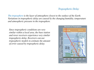
  • 8. The troposphere is the layer of atmosphere closest to the surface of the Earth. Variations in tropospheric delay are caused by the changing humidity, temperature and atmospheric pressure in the troposphere. Tropospheric Delay Since tropospheric conditions are very similar within a local area, the base station and rover receivers experience very similar tropospheric delay. Receivers can use tropospheric models to estimate the amount of error caused by tropospheric delay.
  • 9. MultipathMultipath occurs when a GNSS signal is reflected off an object, such as the wall of a building, to the GNSS antenna. Because the reflected signal travels farther to reach the antenna, the reflected signal arrives at the receiver slightly delayed. This delayed signal can cause the receiver to calculate an incorrect position. The simplest way to reduce multipath errors is to place the GNSS antenna in a location that is away from the reflective surface. When this is not possible, the GNSS receiver and antenna must deal with the multipath signals.
  • 10. The influence of satellite geometry The precision of positioning with GNSS navigation depends on the one hand on the precision of individual pseudorange measurements and on the other hand on the geometric configuration of the satellites used. This configuration is expressed in terms of scalar value DOP (Dilution of Precision) B range measurement with error, green space - area of user possible location A the measurement error is the same, but the error on their position has grown considerably due to the arrangement of the landmarks. C the measurement error is the same, but the error on their position has grown considerably due to the arrangement of the landmarks.
  • 11. Dilution of Precision In any ranging system, receiver-transmitter geometry influences position precision. In (a), the position uncertainty is small (low dilution of precision). In (b), transmitter 2 is moved closer to transmitter 1, and, although the measurement error is the same, the position uncertainty is considerably larger (high dilution of precision)