State of the Art Web Mapping with Open Source
7 likes6,057 views

This document discusses the importance of open source tools and data for web mapping. It begins by providing background on TileMill and Mapbox, which provide open source tools for making maps. It then discusses key concepts in web mapping like geospatial data formats, tile rendering, and minimal code examples. Modern approaches to web mapping involve preprocessing data, using tile renderers and caches, and gradually rendering more client-side. Upcoming improvements may optimize tiled formats and storage. TileMill is demonstrated as an open source tool for making maps. The talk concludes by emphasizing other open mapping tools like CartoDB, Stamen, and CartoDB that build on these concepts.


![CartoCSS
@motorway: #90BFE0;
.highway[TYPE='motorway'] {
.line[zoom>=0] {
line-color: spin(darken(@motorway,36),-10);
line-cap:round;
line-join:round;
}
.fill[zoom>=10] {
line-color:@motorway;
line-cap:round;
line-join:round;}}](https://image.slidesharecdn.com/stateoftheartwebmappingosconspringmeyer-120717194145-phpapp02/85/State-of-the-Art-Web-Mapping-with-Open-Source-23-320.jpg)


![geojson
{ "type": "FeatureCollection",
"features": [
{ "type": "Feature",
"properties": { "name": "PDX" },
"geometry" : { "type": "Point",
"coordinates": [ -122.6, 45.5 ]
}
}]}
Works everywhere: e.g QGIS, TileMill, Web clients](https://image.slidesharecdn.com/stateoftheartwebmappingosconspringmeyer-120717194145-phpapp02/85/State-of-the-Art-Web-Mapping-with-Open-Source-28-320.jpg)


![Leaflet
<html>
<head>
<link rel="stylesheet" href="http://cdn.leafletjs.com/leaflet-0.3.1/leaflet.css" />
<script src="http://cdn.leafletjs.com/leaflet-0.3.1/leaflet.js"></script>
</head>
<body>
! <div id="map" style="width: 100%; height: 100%"></div>
<script>
var map = new L.Map('map');
var osm = new L.TileLayer('http://tile.osm.org/{z}/{x}/{y}.png');
map.setView(new L.LatLng(45.5, -122.65), 12).addLayer(osm);
var pdx = { "type": "FeatureCollection", "features": [ { "type": "Feature",
"properties": { "name": "PDX" },
"geometry" : { "type": "Point","coordinates": [ -122.65, 45.5 ]}}]
};
map.addLayer(new L.GeoJSON(pdx));
</script>
</body>
</html>](https://image.slidesharecdn.com/stateoftheartwebmappingosconspringmeyer-120717194145-phpapp02/85/State-of-the-Art-Web-Mapping-with-Open-Source-33-320.jpg)


State of the Art Web Mapping with Open Source
- 1. State of the Art Web Mapping with Open Source OSCON 2012 | Dane Springmeyer
- 2. @springmeyer github / twitter
- 3. see also: Justin Miller Building a mobile, offline mapping stack using open tools & data 5pm Wednesday, F150
- 4. Background Engineer @ MapBox Building TileMill and Mapnik Web performance / rendering
- 7. We provide services & open source tools
- 8. open source tools to cover
- 13. CartoDB
- 16. TileMill
- 17. •
- 18. maps are simple (a primer)
- 19. geodata as just another data field / type
- 20. cartography as just a sexy form of data visualization
- 21. location: lat/lon, x/y attributes: name, type, value
- 22. styles separate from data akin to css/html
- 23. CartoCSS @motorway: #90BFE0; .highway[TYPE='motorway'] { .line[zoom>=0] { line-color: spin(darken(@motorway,36),-10); line-cap:round; line-join:round; } .fill[zoom>=10] { line-color:@motorway; line-cap:round; line-join:round;}}
- 24. spatial types point: • line: ----------- polygon: _____ |_____|
- 25. Multi* types many to one geometries feature
- 26. tabular geo-csv latitude longitude name 45.5 -122.6 PDX
- 27. tabular geo-csv (multipoint) WKT Name MULTIPOINT ((10 40), (40 30), (20 20), (30 10)) Group of Cities
- 28. geojson { "type": "FeatureCollection", "features": [ { "type": "Feature", "properties": { "name": "PDX" }, "geometry" : { "type": "Point", "coordinates": [ -122.6, 45.5 ] } }]} Works everywhere: e.g QGIS, TileMill, Web clients
- 29. postgis postgis=# select 'POINT(-122.6 45.5)'::geometry as geom,'PDX'::text as name; geom | name --------------------------------------------+------ 01010000006666666666A65EC00000000000C04640 | PDX (1 row) WKB (Well Known Binary)
- 30. postgis postgis=# select ST_Distance('POINT(-122.6 45.5)'::geography,'POINT(-122.3 47.6)'::geography)/1609.344 as dist_in_miles_from_pdx_to_sea; dist_in_miles_from_pdx_to_sea ------------------------------- 145.755555956692 (1 row)
- 31. minimal code for simple maps, both server and client
- 32. Mapnik var mapnik = require('mapnik'); var map = new mapnik.Map(256, 256); map.loadSync('map.xml'); map.zoomAll(); map.renderFileSync('map.png');
- 33. Leaflet <html> <head> <link rel="stylesheet" href="http://cdn.leafletjs.com/leaflet-0.3.1/leaflet.css" /> <script src="http://cdn.leafletjs.com/leaflet-0.3.1/leaflet.js"></script> </head> <body> ! <div id="map" style="width: 100%; height: 100%"></div> <script> var map = new L.Map('map'); var osm = new L.TileLayer('http://tile.osm.org/{z}/{x}/{y}.png'); map.setView(new L.LatLng(45.5, -122.65), 12).addLayer(osm); var pdx = { "type": "FeatureCollection", "features": [ { "type": "Feature", "properties": { "name": "PDX" }, "geometry" : { "type": "Point","coordinates": [ -122.65, 45.5 ]}}] }; map.addLayer(new L.GeoJSON(pdx)); </script> </body> </html>
- 34. •
- 35. but maps are hard
- 36. geodata can be messy and multi- resolution
- 37. geodata can be huge
- 38. geodata can be dynamic
- 39. data story takes too long
- 40. maps as the single lock-in point (google) or point of failure (Slow WMS, IE support, clashing design)
- 41. •
- 42. how modern web maps work
- 43. or, how to tell stories with maps quickly, ensure they are fast under load and work in IE
- 44. open data osm.org naturalearthdata.com us census (geo/www/tiger) local governments portals
- 46. gradually work clientside
- 47. tile renderers mapnik / mapserver
- 50. beautiful graphics Antigrain Geometry Cairo Graphics
- 51. standard formats geojson, wkt, csv, shapefile, postgis, geotiff
- 52. tiled data
- 53. bake big data bitmaps
- 54. pre-render where possible, but beware the world is big
- 60. coming... optimized tiled formats like msgpack, protobuf (not just bitmaps)
- 61. coming ... optimized tiled storage and indexing
- 62. coming ... more robust and configurable clientside renderers
- 63. UI: Browser JS client / Mobile Native client Render: Display: Hardware Vector <img> tiles Renderer Data Tiles: Image Tiles: Optimized vectors Software Vector Renderer Storage: Database / Flat file (Spatially Indexed) Data Processing: GIS Apps, Scripting
- 64. UI: Leaflet / ModestMaps / RouteMe Render: Display: Kothic.js / Vecnik all browers (Canvas/WebGL in support some browsers) Data Tiles: Image Tiles: TileStache / Mapnik via TileMill Kothic.js / or TileStache TileMill ? + UTFGrid interactivity Storage: Postgres-PostGIS / CSV / GeoJSON Data Processing: Qgis, R stats, Python, SQL
- 65. •
- 68. TileMill: Ubuntu sudo apt-add-repository ppa:developmentseed/mapbox sudo apt-get -y update sudo apt-get -y install tilemill sudo start tilemill
- 69. TileMill: Mac
- 70. TileMill: Basics Cross platform - Linux, Win, OS X Same code both desktop & web Outputs PNG, MBTiles, Mapnik XML Written in Javascript (Node.js) and C ++ (Mapnik)
- 71. Art of the possible
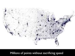
- 74. foursquare.com
- 77. Millions of points without sacrificing speed
- 78. TileMill: Live http://bit.ly/MFjLnG http://bit.ly/SFeBfJ Ec2 machines only available on July 17,2012 set one up yourself like: http://mapbox.com/tilemill/docs/ guides/ubuntu-service/
- 79. Demos... • TileMill: layer ordering, fonts, labeling, plugins, mbtiles export, mapnik xml export, svg/marker-transforms • TileMill: reinforce basics through demos: arc.js geojson, cartodb csv, etherpad csv • OSM-bright setup
- 80. Thanks! @springmeyer github / twitter [email protected]
- 81. •
- 82. Do not miss Stamen and Vizzuality (Cartodb)
- 93. IVE doi:10.1038/nature10836 pen computer programs m-Cumming3 idence that cannot be entirely included in publications, but the rise of layer of inaccessibility. Although it is now accepted that data should be made ons regarding the availability of software are inconsistent. We argue that, with elease of source programs is intolerable for results that depend on computation. nd natural language will always ensure that exact reproducibility remains es the chances that efforts to reproduce results will fail. d to unprecedented rerunning of the code on, say, a different combination of hardware and e powerful computers systems software, to detect the sort of numerical computation11,12 and were thought almost interpretation13 problems found in programming languages, which we gies allow data collec- discuss later. Without code, direct reproducibility is impossible. Indirect data are collected, and reproducibility refers to independent efforts to validate something other vailable with which to than the entire code package, for example a subset of equations or a par- ticular code module. Here, before time-consuming reprogramming of an y, by which we mean entire model, researchers may simply want to check that incorrect coding of ing, rather than exact previously published equations has not invalidated a paper’s result, to n to several decimal extract and check detailed assumptions, or to run their own code against (for an early attempt the original to check for statistical validity and explain any discrepancies. y available computer Any debate over the difficulties of reproducibility (which, as we will d the point that, with show, are non-trivial) must of course be tempered by recognizing the ual source code is an undeniable benefits afforded by the explosion of internet facilities and the depend on computa- rapid increase in raw computational speed and data-handling capability dless, and needlessly that has occurred as a result of major advances in computer technology14. Such advances have presented science with a great opportunity to address computer programs problems that would have been intractable in even the recent past. It is cies still ranging from our view, however, that the debate over code release should be resolved as ral language descrip- soon as possible to benefit fully from our novel technical capabilities. On program algorithms. their own, finer computational grids, longer and more complex compu- n computer program tations and larger data sets—although highly attractive to scientific e in the list of items researchers—do not resolve underlying computational uncertainties of