SlideShare a Scribd company logo
Martin  Christen,  Stephan  Nebiker
FHNW  – University  of Applied  Sciences and Arts  Northwestern Switzerland
Institute  of Geomatics Engineering
martin.christen@fhnw.ch
@MartinChristen
Visualisation  of  Complex  3D  City  Models  on  Mobile  
Webbrowsers Using  Cloud-­based   Image  Provisioning
• Virtual  Globe using WebGL
• Open  Source  Project  started in  
April  2011
• Based on  C++  version started
in  2005
• JavaScript  Library  for rapid  
development of web-­based
geospatial 3D  applications
22  October  2015 2
Previous Work
Institute  of  Geomatics  Engineering
2  October  2015Institute  of  Geomatics  Engineering 3
Demo http://world.openwebglobe.org
2  October  2015Institute  of  Geomatics  Engineering
Streaming  3D-­Geometry  Tiles
MapData  ©  OpenStreetMap  contributors
4
BTh Hürbi/Daetwyler,  MTh Lucas  Oertli,  2013
2  October  2015Institute  of  Geomatics  Engineering 5
Streaming  Example:  3D  Geometry  using  OSM  and  “BOI”  (worldwide   streaming)
MTh Lucas  Oertli,  2013
2  October  2015Institute  of  Geomatics  Engineering 6
Streaming  Example:  Osnabrück (local   streaming)
Created  by  Geoplex with  Plexmap,  based  on  OpenWebGlobe
2  October  2015Institute  of  Geomatics  Engineering 7
Some  Problems  I  have  with  (Web-­Based)  Virtual  Globes
• Unfortunately,  WebGL compatibility  is  still  an  issue…  a  “fallback”  is  required
• Most  people  still  prefer  2D  Maps
• Navigation  in  3D  is  too  complicated  for  many  users…
• In  the  “Geo-­World”,  3D  Models  are  usually  not  built  by  3D  game  designers:
• Often  there  are  “too  many”  &  “too  big”  textures  per  object
• Different  details  per  3D-­object
• Remember  “Google  3D  Warehouse”
• Level  of  Detail:  Generalization  in  2D  is  accepted,    but  not  in  3D!
• Limited  number  of  people  actually  do  have  data  of  the  whole  world…
• Most  virtual  globe  based  applications  I  know  are  limited  to  a  certain  region/country/…
• Too  slow  (bandwidth/3D  rendering)  on  mobile  devices
• Too  power  consuming  on  mobile  devices
2  October  2015Institute  of  Geomatics  Engineering 8
Bringing  together  2D  Maps  and  3D  Globes
Concept:   Prerender a  3D  Scene   using  a  high  quality  offline  3D  renderer   using  an  
orthographic   projection   and  create  “2D”  image   tiles.  
Constant,   minimal  bandwidth  
regardless   of  the  complexity   of  the  
3D  city  model
MTh Markus  Jung,  2014
(Similar  approaches  were  already  done  by  Döllner et  al.  and  also  go  back  to  some  concepts  by  Sutherland)
2  October  2015Institute  of  Geomatics  Engineering 9
Display  in  the  Webbrowser as  “2D  Map”
MTh Markus  Jung,  2014
2  October  2015Institute  of  Geomatics  Engineering 10
Display  in  the  Webbrowser as  Panorama
MTh Markus  Jung,  2014
2  October  2015Institute  of  Geomatics  Engineering 11
High  Resolution  Geometry  doesn’t  matter:  Same  download/render  speed
MTh Markus  Jung,  2014
2  October  2015Institute  of  Geomatics  Engineering 12
The  3dmaps.ch  Project:  Bringing  it  all  together!
3DPS  (3D  Portrayal  Service)
2  October  2015Institute  of  Geomatics  Engineering 13
Viewer  API
map3d.js   Library
var map = new map3d.map("mapcanvas");
var layer = new map3d.imageLayer([
"http://t1.3dmaps.ch/tiles/teatime",
"http://t2.3dmaps.ch/tiles/teatime",
"http://t3.3dmaps.ch/tiles/teatime",
"http://t4.3dmaps.ch/tiles/teatime"]) });
layer.addTo(map);
var teapot_marker = new map3d.marker("Green Teapot", [0,0,0]);
teapot_marker.addTo(map);
var cube_maker = new map3d.marker("Green Cube", [80.5, 11.5, 10.5]);
cube_maker.addTo(map);
2  October  2015Institute  of  Geomatics  Engineering 14
Different  prerenderings for  different  pitch/view  direction
Every  Prerendering needs  storage,  but  with  todays  cloud  storage  pricing  this  is  not  really  an  issue  anymore!  
2  October  2015Institute  of  Geomatics  Engineering 15
Why  a  teapot  if  we  have  (open)  Geo  Data  ?!!
Use  case  1:  Rotterdam  Dataset
90  CityGML files  with  a  total   size  of  2.72  GB
26'474   textures   with  a  size  of  1024x1024,   an  uncompressed   total   data  volume   of  around   77  GB
Orthophoto uncompressed   430  GB
2  October  2015Institute  of  Geomatics  Engineering 16
Use  case  2:  The  Roman  city  of  Augusta  Raurica
A  digital  reconstruction  of  the  historical  Roman  City  of  Augusta  Raurica,  created  at  
the  institute  of  Geomatics Engineering at  the  FHNW.  3D-­Printed  to  create  a  bronze  
model.  
2  October  2015Institute  of  Geomatics  Engineering 17
The  3D  Model
About  4000  geospatial  objects  (buildings,  roads,  vegetation  features,  terrain,  …)  
at  three  levels  of  detail.  
3D  Geometry:  172  MB
Textures:  350  MB  
2  October  2015Institute  of  Geomatics  Engineering 18
Prerendering the  Model:  Color  Map,  Normal  Map,  Id-­Map,  Depth  Map
Dynamic   Lighting
Normal   Map:   for  Object  Identification:  
Highlighting,   special  effects,   …
Depth   Map:   for  3D  Position,   special  effects,   …  
2  October  2015Institute  of  Geomatics  Engineering 19
3D  View  in  the  (mobile)  webbrowser with  dynamic  Lighting
2  October  2015Institute  of  Geomatics  Engineering 20
The  Viewer
• The  viewer  basically  uses  the  same  concepts  as  a  “2D  Map  Viewer”
• map3d.js  supports  WebGL
There  is  also  a  pure  canvas  version  available  as  fallback
• Operations  like  “highlighting”  are  highly  customizable.  Basically  it  is  an  image  
processing  operation  which  runs  on  the  GPU  (WebGL Version).  If  there  is  no  
WebGL available,  the  operation  is  done  using  JavaScript.
2  October  2015Institute  of  Geomatics  Engineering 21
Outlook  (1)
• Implement  more  effects  and  lighting  models,  
dynamic  snow/water/etc.  using  depth  map  &  normal  map
• Layer  management  (include  point  clouds,  mix  different  layers  using  depth  
map
• Add  realtime content  (“mix  real  3D  Object”)  using  depth-­map
• Release  map3d.js  as  Open  Source  (not  before  2016)
2  October  2015Institute  of  Geomatics  Engineering 22
Outlook  (2)
More  Rendering  Effects,  for  example  Screen  Space  Ambient  Occlusion  (SSAO)
BTh,  Daniel  Rettenmund 2015
2  October  2015Institute  of  Geomatics  Engineering 23
Outlook  (3)
• “isometric  maps”  will  be  one  of  many  features  of  OpenWebGlobe 2
• “isometric  maps”  will  be  the  default  3D  Viewer  in  OpenWebGlobe 2
• Switch  to  “real  3D”  anytime
• State  is  saved:  
• The  best  matching  viewpoint   is  selected  when  switching
• If  you  highlight  an  object  in  “isometric  mode”,  it  will  be  highlighted   in  
“Real  3D”  mode  too.
2  October  2015Institute  of  Geomatics  Engineering 24
Conclusion
• Using  Image  Provisioning  (“isometric  maps”)  we  have  a  “3D  Streaming”  with  
constant  speed,  no  matter  how  complex  the  geometry/textures  are.
• It  runs  on  nearly  every  mobile  phone  with  a  webbrowser
• Thanks  to  cloud  storage,  we  can  have  near  unlimited  number  of  views  with  
different  “look-­at-­angles”
• Navigation  is  really  easy!
Everyone  who  can  handle  2D  maps  can  handle  isometric  3D  Maps  (pan  &  
zoom)
• If  WebGL is  available  it  uses  WebGL
Otherwise:  fallback  to  HTML5  Canvas.
• No  limitation  in  numbers  of  users  (viewers)  at  the  same  time
2  October  2015Institute  of  Geomatics  Engineering 25
Questions

More Related Content

What's hot (20)

PDF
Act 00085 i towns, nouveau framework pour la visualisation 3d web
ACSG Section Montréal
 
PDF
Processing Landsat 8 Multi-Spectral Images with GRASS Tools & the potential o...
Shaun Lewis
 
PDF
Let's integrate CAD/BIM/GIS on the same platform: A practical approach in rea...
SANGHEE SHIN
 
PDF
Let’s Power the Analytics and 3D to the Web Based Military Geo-Portal using F...
SANGHEE SHIN
 
PDF
Introduction to mago3D: A web based GeoBIM platform on top of FOSS4G
SANGHEE SHIN
 
PDF
Mago3D - An innovative AEC/GIS integration platform that can service millions...
SANGHEE SHIN
 
PDF
Current State of mago3D, an Open Source Based Digital Twin Platform
SANGHEE SHIN
 
ODP
OSGeo: projects, incubation and infrastructure
Markus Neteler
 
PDF
How to Get the Most Out of LiDAR Data
Safe Software
 
PDF
Q-GIS-AN OPEN SOURCE SOFTWARE DEMONSTRATION
Bhupen Barman
 
PDF
Vector Tile for Sea Wind
SANGHEE SHIN
 
PDF
BIM/GIS Integration: A Practical Approach in Real Cases
SANGHEE SHIN
 
PDF
GRASS GIS e Sextante
Markus Neteler
 
PDF
mago3D - A Brand-New Live 3D Geo-Platform
SANGHEE SHIN
 
PDF
AGIT 2017: Cesium 1.35, WebGL Virtual Globe and Map Engine
Camptocamp
 
PDF
OpenLayers Feature Frenzy
Andreas Hocevar
 
PDF
mago3D Technical Workshop Material(New Version)
SANGHEE SHIN
 
PDF
Graph operations in Git version control system
Jakub Narębski
 
PDF
mago3D: A brand new Geo-BIM platform on top of Cesium & World Wind
SANGHEE SHIN
 
PDF
OL3-Cesium: 3D for OpenLayers maps
Andreas Hocevar
 
Act 00085 i towns, nouveau framework pour la visualisation 3d web
ACSG Section Montréal
 
Processing Landsat 8 Multi-Spectral Images with GRASS Tools & the potential o...
Shaun Lewis
 
Let's integrate CAD/BIM/GIS on the same platform: A practical approach in rea...
SANGHEE SHIN
 
Let’s Power the Analytics and 3D to the Web Based Military Geo-Portal using F...
SANGHEE SHIN
 
Introduction to mago3D: A web based GeoBIM platform on top of FOSS4G
SANGHEE SHIN
 
Mago3D - An innovative AEC/GIS integration platform that can service millions...
SANGHEE SHIN
 
Current State of mago3D, an Open Source Based Digital Twin Platform
SANGHEE SHIN
 
OSGeo: projects, incubation and infrastructure
Markus Neteler
 
How to Get the Most Out of LiDAR Data
Safe Software
 
Q-GIS-AN OPEN SOURCE SOFTWARE DEMONSTRATION
Bhupen Barman
 
Vector Tile for Sea Wind
SANGHEE SHIN
 
BIM/GIS Integration: A Practical Approach in Real Cases
SANGHEE SHIN
 
GRASS GIS e Sextante
Markus Neteler
 
mago3D - A Brand-New Live 3D Geo-Platform
SANGHEE SHIN
 
AGIT 2017: Cesium 1.35, WebGL Virtual Globe and Map Engine
Camptocamp
 
OpenLayers Feature Frenzy
Andreas Hocevar
 
mago3D Technical Workshop Material(New Version)
SANGHEE SHIN
 
Graph operations in Git version control system
Jakub Narębski
 
mago3D: A brand new Geo-BIM platform on top of Cesium & World Wind
SANGHEE SHIN
 
OL3-Cesium: 3D for OpenLayers maps
Andreas Hocevar
 

Viewers also liked (20)

PPTX
OpenStreetMap in 3D using Python
Martin Christen
 
PDF
GeoBeer July 3rd, 2013
Martin Christen
 
PPTX
3d mit Python (PythonCamp)
Martin Christen
 
PDF
Docker for Python Development
Martin Christen
 
PDF
Gettiing Started with IoT using Raspberry Pi and Python
Martin Christen
 
PDF
Putting Your Data on a Map
Shawn Day
 
PPTX
Augview presentation GE user conference bali 2014 - MIke Bundock
Geo AR Games
 
PDF
Best Web-based Data Visualization tools
Atchai
 
PPT
An Overview of Web GIS and Location Based Services
webmapsolutions
 
PDF
Standard_Digital_Cadastral_Maps_2015_Adopted
Michael Prestridge
 
PDF
3D Web Services And Models For The Web: Where Do We Stand?
Camptocamp
 
PPTX
Using unique and unusual archival records and data to illustrate and annotate...
ICARUS - International Centre for Archival Research
 
PPT
Tips for Manipulating Data in Esri Geodatabase using FME
Safe Software
 
PPTX
Curso de Geodatabase
Instituto Nacional de Tierras
 
PPT
Google Maps API
hchen1
 
PPT
Geospatial Web
hchen1
 
PDF
Introducción a la geodatabase del SIOSE (I)
Benito Zaragozí
 
PPT
Digital cadaster in Bulgaria. Information system of cadaster and property reg...
Geoskills+ Project
 
PDF
Introducción a la geodatabase del SIOSE (II)
Benito Zaragozí
 
PPTX
SportsDataViz using Plotly, Shiny and Flexdashboard - PlotCon 2016
Tanya Cashorali
 
OpenStreetMap in 3D using Python
Martin Christen
 
GeoBeer July 3rd, 2013
Martin Christen
 
3d mit Python (PythonCamp)
Martin Christen
 
Docker for Python Development
Martin Christen
 
Gettiing Started with IoT using Raspberry Pi and Python
Martin Christen
 
Putting Your Data on a Map
Shawn Day
 
Augview presentation GE user conference bali 2014 - MIke Bundock
Geo AR Games
 
Best Web-based Data Visualization tools
Atchai
 
An Overview of Web GIS and Location Based Services
webmapsolutions
 
Standard_Digital_Cadastral_Maps_2015_Adopted
Michael Prestridge
 
3D Web Services And Models For The Web: Where Do We Stand?
Camptocamp
 
Using unique and unusual archival records and data to illustrate and annotate...
ICARUS - International Centre for Archival Research
 
Tips for Manipulating Data in Esri Geodatabase using FME
Safe Software
 
Curso de Geodatabase
Instituto Nacional de Tierras
 
Google Maps API
hchen1
 
Geospatial Web
hchen1
 
Introducción a la geodatabase del SIOSE (I)
Benito Zaragozí
 
Digital cadaster in Bulgaria. Information system of cadaster and property reg...
Geoskills+ Project
 
Introducción a la geodatabase del SIOSE (II)
Benito Zaragozí
 
SportsDataViz using Plotly, Shiny and Flexdashboard - PlotCon 2016
Tanya Cashorali
 
Ad

Similar to Visualisation of Complex 3D City Models on Mobile Webbrowsers Using Cloud-based Image Provisioning (20)

PPTX
OpenStreetMap in 3D - current developments
virtualcitySYSTEMS GmbH
 
PDF
3D webservices - where do we stand? (ENG)
Camptocamp
 
PDF
Europeana goes 3D
Daniel Pletinckx
 
PDF
3D ICONS: Europeana goes 3D, Daniel Pletinckx, Visual Dimension Belgium
3D ICONS Project
 
PDF
Tools for Visualizing Geospatial Data in a Web Browser
Safe Software
 
PPTX
Introduction to 3D Data
John Reiser
 
PDF
Ta Lab Hour Feb9 2011 Bolin
chamberlinfaye
 
PDF
3D World Heritage at your fingertips: what to expect? Online solutions to the...
3D ICONS Project
 
PDF
High-Quality Server Side Rendering using the OGC’s 3D Portrayal Service – App...
Martin Christen
 
PPTX
Foss4g 2016 How to make a 3D web geoportal
geoportal of the federal authorities of the Swiss Confederation
 
PDF
Scianna & Sciortino - input2012
INPUT 2012
 
PPTX
Modelling - Third dimension.pptx
Aliya Fathima Ilyas
 
PDF
Web-based and Mobile Provisioning of Virtual 3D Reconstructions
Matthias Trapp
 
PDF
Embedding user generated content into oblique airborne photogrammetry based 3...
Jianming Liang
 
PPS
3D models: issues of accuracy
Rollo Home
 
PDF
ViziCities - Lessons Learnt Visualising Real-world Cities in 3D
Robin Hawkes
 
PPTX
Use of CityGML standard in the context of Smart City
i-SCOPE Project
 
PDF
Visualization and Level-of-detail of Metadata for Interactive Exploration of ...
Cybera Inc.
 
PDF
How 3D GIS connects the real world with virtual worlds
Niels van der Vaart
 
DOCX
09165566d individual
lsgi4321
 
OpenStreetMap in 3D - current developments
virtualcitySYSTEMS GmbH
 
3D webservices - where do we stand? (ENG)
Camptocamp
 
Europeana goes 3D
Daniel Pletinckx
 
3D ICONS: Europeana goes 3D, Daniel Pletinckx, Visual Dimension Belgium
3D ICONS Project
 
Tools for Visualizing Geospatial Data in a Web Browser
Safe Software
 
Introduction to 3D Data
John Reiser
 
Ta Lab Hour Feb9 2011 Bolin
chamberlinfaye
 
3D World Heritage at your fingertips: what to expect? Online solutions to the...
3D ICONS Project
 
High-Quality Server Side Rendering using the OGC’s 3D Portrayal Service – App...
Martin Christen
 
Foss4g 2016 How to make a 3D web geoportal
geoportal of the federal authorities of the Swiss Confederation
 
Scianna & Sciortino - input2012
INPUT 2012
 
Modelling - Third dimension.pptx
Aliya Fathima Ilyas
 
Web-based and Mobile Provisioning of Virtual 3D Reconstructions
Matthias Trapp
 
Embedding user generated content into oblique airborne photogrammetry based 3...
Jianming Liang
 
3D models: issues of accuracy
Rollo Home
 
ViziCities - Lessons Learnt Visualising Real-world Cities in 3D
Robin Hawkes
 
Use of CityGML standard in the context of Smart City
i-SCOPE Project
 
Visualization and Level-of-detail of Metadata for Interactive Exploration of ...
Cybera Inc.
 
How 3D GIS connects the real world with virtual worlds
Niels van der Vaart
 
09165566d individual
lsgi4321
 
Ad

More from Martin Christen (6)

PDF
Opening Session GeoPython & Python Machine Learning Conference
Martin Christen
 
PDF
EuroPython 2019: GeoSpatial Analysis using Python and JupyterHub
Martin Christen
 
PPTX
Lightning Talk GeoBeer #25
Martin Christen
 
PDF
Teaching with JupyterHub - lessons learned
Martin Christen
 
PDF
Mixed Reality Anwendungen mit 3D-Stadtmodellen
Martin Christen
 
PDF
3D Computer Graphics with Python
Martin Christen
 
Opening Session GeoPython & Python Machine Learning Conference
Martin Christen
 
EuroPython 2019: GeoSpatial Analysis using Python and JupyterHub
Martin Christen
 
Lightning Talk GeoBeer #25
Martin Christen
 
Teaching with JupyterHub - lessons learned
Martin Christen
 
Mixed Reality Anwendungen mit 3D-Stadtmodellen
Martin Christen
 
3D Computer Graphics with Python
Martin Christen
 

Recently uploaded (20)

PDF
[Newgen] NewgenONE Marvin Brochure 1.pdf
darshakparmar
 
PDF
Automating Feature Enrichment and Station Creation in Natural Gas Utility Net...
Safe Software
 
PPTX
The Project Compass - GDG on Campus MSIT
dscmsitkol
 
PPTX
Mastering ODC + Okta Configuration - Chennai OSUG
HathiMaryA
 
PPTX
New ThousandEyes Product Innovations: Cisco Live June 2025
ThousandEyes
 
PDF
The Rise of AI and IoT in Mobile App Tech.pdf
IMG Global Infotech
 
PPT
Ericsson LTE presentation SEMINAR 2010.ppt
npat3
 
PPTX
Agentforce World Tour Toronto '25 - MCP with MuleSoft
Alexandra N. Martinez
 
PPTX
From Sci-Fi to Reality: Exploring AI Evolution
Svetlana Meissner
 
PPTX
Designing_the_Future_AI_Driven_Product_Experiences_Across_Devices.pptx
presentifyai
 
PDF
What’s my job again? Slides from Mark Simos talk at 2025 Tampa BSides
Mark Simos
 
DOCX
Python coding for beginners !! Start now!#
Rajni Bhardwaj Grover
 
PDF
The 2025 InfraRed Report - Redpoint Ventures
Razin Mustafiz
 
PDF
CIFDAQ Market Wrap for the week of 4th July 2025
CIFDAQ
 
PPTX
Q2 FY26 Tableau User Group Leader Quarterly Call
lward7
 
PPTX
Seamless Tech Experiences Showcasing Cross-Platform App Design.pptx
presentifyai
 
DOCX
Cryptography Quiz: test your knowledge of this important security concept.
Rajni Bhardwaj Grover
 
PPTX
Digital Circuits, important subject in CS
contactparinay1
 
PDF
UiPath DevConnect 2025: Agentic Automation Community User Group Meeting
DianaGray10
 
PPTX
MuleSoft MCP Support (Model Context Protocol) and Use Case Demo
shyamraj55
 
[Newgen] NewgenONE Marvin Brochure 1.pdf
darshakparmar
 
Automating Feature Enrichment and Station Creation in Natural Gas Utility Net...
Safe Software
 
The Project Compass - GDG on Campus MSIT
dscmsitkol
 
Mastering ODC + Okta Configuration - Chennai OSUG
HathiMaryA
 
New ThousandEyes Product Innovations: Cisco Live June 2025
ThousandEyes
 
The Rise of AI and IoT in Mobile App Tech.pdf
IMG Global Infotech
 
Ericsson LTE presentation SEMINAR 2010.ppt
npat3
 
Agentforce World Tour Toronto '25 - MCP with MuleSoft
Alexandra N. Martinez
 
From Sci-Fi to Reality: Exploring AI Evolution
Svetlana Meissner
 
Designing_the_Future_AI_Driven_Product_Experiences_Across_Devices.pptx
presentifyai
 
What’s my job again? Slides from Mark Simos talk at 2025 Tampa BSides
Mark Simos
 
Python coding for beginners !! Start now!#
Rajni Bhardwaj Grover
 
The 2025 InfraRed Report - Redpoint Ventures
Razin Mustafiz
 
CIFDAQ Market Wrap for the week of 4th July 2025
CIFDAQ
 
Q2 FY26 Tableau User Group Leader Quarterly Call
lward7
 
Seamless Tech Experiences Showcasing Cross-Platform App Design.pptx
presentifyai
 
Cryptography Quiz: test your knowledge of this important security concept.
Rajni Bhardwaj Grover
 
Digital Circuits, important subject in CS
contactparinay1
 
UiPath DevConnect 2025: Agentic Automation Community User Group Meeting
DianaGray10
 
MuleSoft MCP Support (Model Context Protocol) and Use Case Demo
shyamraj55
 

Visualisation of Complex 3D City Models on Mobile Webbrowsers Using Cloud-based Image Provisioning

  • 1. Martin  Christen,  Stephan  Nebiker FHNW  – University  of Applied  Sciences and Arts  Northwestern Switzerland Institute  of Geomatics Engineering [email protected] @MartinChristen Visualisation  of  Complex  3D  City  Models  on  Mobile   Webbrowsers Using  Cloud-­based   Image  Provisioning
  • 2. • Virtual  Globe using WebGL • Open  Source  Project  started in   April  2011 • Based on  C++  version started in  2005 • JavaScript  Library  for rapid   development of web-­based geospatial 3D  applications 22  October  2015 2 Previous Work Institute  of  Geomatics  Engineering
  • 3. 2  October  2015Institute  of  Geomatics  Engineering 3 Demo http://world.openwebglobe.org
  • 4. 2  October  2015Institute  of  Geomatics  Engineering Streaming  3D-­Geometry  Tiles MapData  ©  OpenStreetMap  contributors 4 BTh Hürbi/Daetwyler,  MTh Lucas  Oertli,  2013
  • 5. 2  October  2015Institute  of  Geomatics  Engineering 5 Streaming  Example:  3D  Geometry  using  OSM  and  “BOI”  (worldwide   streaming) MTh Lucas  Oertli,  2013
  • 6. 2  October  2015Institute  of  Geomatics  Engineering 6 Streaming  Example:  Osnabrück (local   streaming) Created  by  Geoplex with  Plexmap,  based  on  OpenWebGlobe
  • 7. 2  October  2015Institute  of  Geomatics  Engineering 7 Some  Problems  I  have  with  (Web-­Based)  Virtual  Globes • Unfortunately,  WebGL compatibility  is  still  an  issue…  a  “fallback”  is  required • Most  people  still  prefer  2D  Maps • Navigation  in  3D  is  too  complicated  for  many  users… • In  the  “Geo-­World”,  3D  Models  are  usually  not  built  by  3D  game  designers: • Often  there  are  “too  many”  &  “too  big”  textures  per  object • Different  details  per  3D-­object • Remember  “Google  3D  Warehouse” • Level  of  Detail:  Generalization  in  2D  is  accepted,    but  not  in  3D! • Limited  number  of  people  actually  do  have  data  of  the  whole  world… • Most  virtual  globe  based  applications  I  know  are  limited  to  a  certain  region/country/… • Too  slow  (bandwidth/3D  rendering)  on  mobile  devices • Too  power  consuming  on  mobile  devices
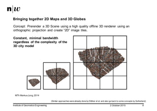
  • 8. 2  October  2015Institute  of  Geomatics  Engineering 8 Bringing  together  2D  Maps  and  3D  Globes Concept:   Prerender a  3D  Scene   using  a  high  quality  offline  3D  renderer   using  an   orthographic   projection   and  create  “2D”  image   tiles.   Constant,   minimal  bandwidth   regardless   of  the  complexity   of  the   3D  city  model MTh Markus  Jung,  2014 (Similar  approaches  were  already  done  by  Döllner et  al.  and  also  go  back  to  some  concepts  by  Sutherland)
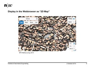
  • 9. 2  October  2015Institute  of  Geomatics  Engineering 9 Display  in  the  Webbrowser as  “2D  Map” MTh Markus  Jung,  2014
  • 10. 2  October  2015Institute  of  Geomatics  Engineering 10 Display  in  the  Webbrowser as  Panorama MTh Markus  Jung,  2014
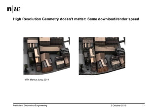
  • 11. 2  October  2015Institute  of  Geomatics  Engineering 11 High  Resolution  Geometry  doesn’t  matter:  Same  download/render  speed MTh Markus  Jung,  2014
  • 12. 2  October  2015Institute  of  Geomatics  Engineering 12 The  3dmaps.ch  Project:  Bringing  it  all  together! 3DPS  (3D  Portrayal  Service)
  • 13. 2  October  2015Institute  of  Geomatics  Engineering 13 Viewer  API map3d.js   Library var map = new map3d.map("mapcanvas"); var layer = new map3d.imageLayer([ "http://t1.3dmaps.ch/tiles/teatime", "http://t2.3dmaps.ch/tiles/teatime", "http://t3.3dmaps.ch/tiles/teatime", "http://t4.3dmaps.ch/tiles/teatime"]) }); layer.addTo(map); var teapot_marker = new map3d.marker("Green Teapot", [0,0,0]); teapot_marker.addTo(map); var cube_maker = new map3d.marker("Green Cube", [80.5, 11.5, 10.5]); cube_maker.addTo(map);
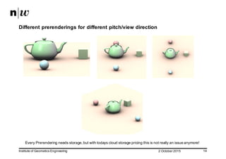
  • 14. 2  October  2015Institute  of  Geomatics  Engineering 14 Different  prerenderings for  different  pitch/view  direction Every  Prerendering needs  storage,  but  with  todays  cloud  storage  pricing  this  is  not  really  an  issue  anymore!  
  • 15. 2  October  2015Institute  of  Geomatics  Engineering 15 Why  a  teapot  if  we  have  (open)  Geo  Data  ?!! Use  case  1:  Rotterdam  Dataset 90  CityGML files  with  a  total   size  of  2.72  GB 26'474   textures   with  a  size  of  1024x1024,   an  uncompressed   total   data  volume   of  around   77  GB Orthophoto uncompressed   430  GB
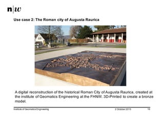
  • 16. 2  October  2015Institute  of  Geomatics  Engineering 16 Use  case  2:  The  Roman  city  of  Augusta  Raurica A  digital  reconstruction  of  the  historical  Roman  City  of  Augusta  Raurica,  created  at   the  institute  of  Geomatics Engineering at  the  FHNW.  3D-­Printed  to  create  a  bronze   model.  
  • 17. 2  October  2015Institute  of  Geomatics  Engineering 17 The  3D  Model About  4000  geospatial  objects  (buildings,  roads,  vegetation  features,  terrain,  …)   at  three  levels  of  detail.   3D  Geometry:  172  MB Textures:  350  MB  
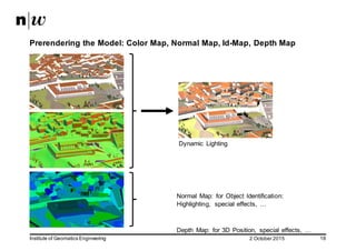
  • 18. 2  October  2015Institute  of  Geomatics  Engineering 18 Prerendering the  Model:  Color  Map,  Normal  Map,  Id-­Map,  Depth  Map Dynamic   Lighting Normal   Map:   for  Object  Identification:   Highlighting,   special  effects,   … Depth   Map:   for  3D  Position,   special  effects,   …  
  • 19. 2  October  2015Institute  of  Geomatics  Engineering 19 3D  View  in  the  (mobile)  webbrowser with  dynamic  Lighting
  • 20. 2  October  2015Institute  of  Geomatics  Engineering 20 The  Viewer • The  viewer  basically  uses  the  same  concepts  as  a  “2D  Map  Viewer” • map3d.js  supports  WebGL There  is  also  a  pure  canvas  version  available  as  fallback • Operations  like  “highlighting”  are  highly  customizable.  Basically  it  is  an  image   processing  operation  which  runs  on  the  GPU  (WebGL Version).  If  there  is  no   WebGL available,  the  operation  is  done  using  JavaScript.
  • 21. 2  October  2015Institute  of  Geomatics  Engineering 21 Outlook  (1) • Implement  more  effects  and  lighting  models,   dynamic  snow/water/etc.  using  depth  map  &  normal  map • Layer  management  (include  point  clouds,  mix  different  layers  using  depth   map • Add  realtime content  (“mix  real  3D  Object”)  using  depth-­map • Release  map3d.js  as  Open  Source  (not  before  2016)
  • 22. 2  October  2015Institute  of  Geomatics  Engineering 22 Outlook  (2) More  Rendering  Effects,  for  example  Screen  Space  Ambient  Occlusion  (SSAO) BTh,  Daniel  Rettenmund 2015
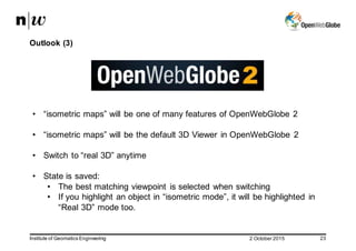
  • 23. 2  October  2015Institute  of  Geomatics  Engineering 23 Outlook  (3) • “isometric  maps”  will  be  one  of  many  features  of  OpenWebGlobe 2 • “isometric  maps”  will  be  the  default  3D  Viewer  in  OpenWebGlobe 2 • Switch  to  “real  3D”  anytime • State  is  saved:   • The  best  matching  viewpoint   is  selected  when  switching • If  you  highlight  an  object  in  “isometric  mode”,  it  will  be  highlighted   in   “Real  3D”  mode  too.
  • 24. 2  October  2015Institute  of  Geomatics  Engineering 24 Conclusion • Using  Image  Provisioning  (“isometric  maps”)  we  have  a  “3D  Streaming”  with   constant  speed,  no  matter  how  complex  the  geometry/textures  are. • It  runs  on  nearly  every  mobile  phone  with  a  webbrowser • Thanks  to  cloud  storage,  we  can  have  near  unlimited  number  of  views  with   different  “look-­at-­angles” • Navigation  is  really  easy! Everyone  who  can  handle  2D  maps  can  handle  isometric  3D  Maps  (pan  &   zoom) • If  WebGL is  available  it  uses  WebGL Otherwise:  fallback  to  HTML5  Canvas. • No  limitation  in  numbers  of  users  (viewers)  at  the  same  time
  • 25. 2  October  2015Institute  of  Geomatics  Engineering 25 Questions