Excessive Rainfall Discussion
NWS Weather Prediction Center College Park MD
408 AM EDT Thu Oct 29 2026
Day 1
Valid 12Z Thu Oct 29 2026 - 12Z Fri Oct 30 2026
...THERE IS A SLIGHT RISK OF EXCESSIVE RAINFALL FOR PORTIONS OF
WEST AND CENTRAL TEXAS AND SOUTHEASTERN NEW MEXICO...
...Texas and New Mexico...
Confidence remains high in a heavy rainfall event this afternoon
through tonight across portions of Texas and New Mexico as a mid-
level disturbance associated with the remnants of TC Vance move
into the region. Southeasterly low-level flow will prime the
atmosphere ahead of the system, increasing PWATs to 1.5-2 inches
across much of Texas, which is well above normal for this time of
year. As the mid-level wave moves across Texas this afternoon and
evening, an upper level southern stream jet will lift across the
southern Plains, placing Texas under the favorable right entrance
region with enhanced upper level divergence. This will create large
scale ascent across the region that should support widespread
convection across Texas and southern New Mexico. The limiting
factor will likely be CAPE, which is expected to be slightly
limited due to widespread cloud cover spreading across the region.
Global models show MUCAPE only reaching around 500-900 J/kg across
West and Central Texas this afternoon, with the higher MUCAPE
(above 1000 J/kg) located over the Texas Panhandle and Oklahoma,
well to the north of where the best synoptic forcing will be.
Models continue to show a corridor of higher rainfall totals (2-5
inches) on the eastern side of the mid-level circulation from the
Stockton and western Edwards Plateaus to southeastern New Mexico,
which is included in a Slight Risk of excessive rainfall area for
today. The Slight Risk area was expanded to include more sensitive
terrain in southeastern New Mexico that should help focus
convection this afternoon and evening. The highest event totals
should focus on the southern side of the Slight Risk area where the
highest moisture values are expected to pool and will likely
produce a high-end Slight Risk scenario. The 00Z HREF and REFS
neighborhood probabilities show high chances (70-90%) of exceeding
3 inches in 24 hours in this area, but only low to mid chances
(less than 30% from the HREF, 30-60% from the REFS) of exceeding 5
inches in 24 hours. Though not likely for most of the area, hi-res
guidance shows there could still be isolated areas with totals up
to 5-7 inches over 24 hours. The HREF and REFS also show low
probabilities of hourly rainfall rates exceeding FFGs, which is not
surprising given the lack of CAPE, but they do show moderate
chances of rainfall rates exceeding the 6 hour FFGs (2-4 inches for
much of the Slight Risk area). The more widespread risk of
flooding will come from the prolonged nature of this event, with
moderate to locally heavy rain expected across much of West and
Central Texas and into southeastern New Mexico through tonight and
into Friday morning.
Surrounding the Slight Risk area, there is a broader Marginal Risk
area that extends across southern New Mexico, which should also be
impacted by scattered showers and storms with this event. The
combination of Gulf and Pacific moisture will allow PWATs to rise
to 0.8-1 inches, and there should be sufficient CAPE (peaking at
900-1200 J/kg this afternoon) to allow for locally heavy rainfall
rates exceeding 1 inch per hour. Heavy rainfall over sensitive
terrain and burn scars could cause flash flooding, especially
considering how saturated soils are after recent heavy rains in
this region.
Dolan
Day 1 threat area:
www.wpc.ncep.noaa.gov/qpf/94epoints.txt
Excessive Rainfall Discussion
NWS Weather Prediction Center College Park MD
408 AM EDT Thu Oct 29 2026
Day 2
Valid 12Z Fri Oct 30 2026 - 12Z Sat Oct 31 2026
...THERE IS A SLIGHT RISK OF EXCESSIVE RAINFALL FOR PORTIONS OF
CENTRAL AND SOUTHERN ARIZONA...
...Southwest...
Broad troughing will develop over the West with embedded shortwave
energy moving across portions of the Southwest on Friday.
Meanwhile, a strong southern stream jet will approach Baja
California, placing Arizona under the favorable left exit region
with enhanced upper level divergence Friday afternoon. Southerly
low-level flow will direct Pacific moisture into the area as well,
bringing PWATs up to 1-1.4 inches across the southern half of
Arizona (2-3 standard deviations above normal). This warm, moist
air mass will also increase instability, with MUCAPE values
forecast to reach 700-1000 J/kg across much of southern Arizona.
With favorable conditions throughout the atmospheric column,
scattered to widespread convection is expected to develop with the
passing of the upper shortwave Friday afternoon and evening.
Deterministic and ensemble model guidance continues to show
elevated rainfall totals along and south of the Mogollon Rim where
there is a Slight Risk of excessive rainfall. Available hi-res and
global models forecast rainfall rates exceeding 3hr FFGs (1-2
inches) across central and southern Arizona on Friday afternoon and
evening. Both the HREF and REFS show moderate probabilities
(30-60%) of 6hr QPF exceeding 2 inches and precipitation exceeding
FFGs. Given the sensitive terrain in the area and relatively moist
soils across central and southern Arizona, this setup will likely
produce scattered instances of flash flooding. A broader Marginal
Risk area surrounds the Slight and includes portions of southern
Utah and New Mexico where there will also be scattered convection,
but the flash flood risk will be more isolated as rainfall rates
are less likely to exceed FFGs.
...Texas and Oklahoma...
Widespread moderate to locally heavy rainfall will continue into
Friday morning across portions of Texas and Oklahoma as the
remnants of TC Vance move northeast across the southern and central
Plains. The southern stream jet should shift north, maintaining
favorable conditions for convection over the area through Friday
afternoon. Anomalous moisture will remain in place across the
southern Plains, but cloud cover will once again limit instability.
With favorable dynamics, there should still be enough support for
locally heavy rainfall, but it will be tough to get rainfall rates
that exceed hourly FFGs. The flood risk will mainly be a function
of duration, with rainfall impacts compounding from Thursday into
Friday. The highest risk of flash flooding will likely materialize
over portions of Texas where the QPF footprints will have a bit of
overlap from Thursday to Friday, but the highest rainfall totals on
Friday should mainly be displaced to the northeast from the
heaviest rainfall on Thursday. The flash flood risk will be
relatively low, but enough for isolated instances of flash flooding
and a Marginal Risk of excessive rainfall.
Dolan
Day 2 threat area:
www.wpc.ncep.noaa.gov/qpf/98epoints.txt
Excessive Rainfall Discussion
NWS Weather Prediction Center College Park MD
408 AM EDT Thu Oct 29 2026
Day 3
Valid 12Z Sat Oct 31 2026 - 12Z Sun Nov 01 2026
...THERE IS A SLIGHT RISK OF EXCESSIVE RAINFALL FOR PORTIONS OF
CENTRAL AND SOUTHERN ARIZONA...
...Southwest...
A deep upper level trough/low will move over the West Coast on
Saturday, sweeping up a potent Pacific shortwave and directing it
into the Southwest by Saturday evening. This system will be
accompanied by an amplified southern stream jet that will enhance
divergence over portions of the Southwest Saturday evening into
Saturday night. Ahead of the system, a stream of subtropical
moisture will increase PWATs above 1 inch across southern
California, southern Nevada, and Arizona, and even above 1.5 inches
for portions of central and southern Arizona. These values are
highly anomalous (4-6 standard deviations above normal) for this
time of year and should support widespread precipitation as the
shortwave moves onshore.
CAPE will be the limiting factor in this scenario, with cloud
cover keeping MUCAPE to only a few hundred J/kg over portions of
central and southern Arizona with little to no CAPE elsewhere.
Given this setup, locally heavy rainfall will be possible across
much of the Southwest, but rainfall rates may be limited outside of
favorable locations in Arizona where there is a Slight Risk of
excessive rainfall. Portions of Arizona will also see heavy
rainfall on Friday, which may increase the sensitivity to flash
flooding with additional rainfall through Saturday night. There is
still some uncertainty in the timing of this system, the GFS is
notably slower than other deterministic (physical and AI) models,
but the WPC forecast favors a faster solution that is closer to the
general model consensus. This event will continue into Sunday, and
conditions are expected to become more conducive for a widespread
heavy rainfall event across the Southwest.
...Central Gulf Coast and Lower Mississippi Valley...
There is potential for locally heavy rainfall somewhere between
the Mid-Mississippi Valley and central Gulf Coast on Saturday, but
the risk of flash flooding is questionable at this time. Over the
Gulf Coast, an amplified jet will create upper level divergence and
southerly flow will increase moisture and instability across the
region. The problem will be that the main shortwave triggering
convection will be strongest to the north in the Midwest and Ohio
Valley. With these ingredients out of sync, it will be hard to get
heavy rainfall that exceeds FFGs. Global models have trended lower
with QPF, now showing a broad area of 0.5-2 inches over 24 hours,
with a high amount of uncertainty in location of the higher totals.
Soils from the Mid-Mississippi Valley to the Gulf Coast are
anomalously dry, resulting in high FFGs. Most of the area would
need over 3 inches of rainfall to cause flash flooding, which is
looking unlikely at this time, so the inherited Marginal Risk of
excessive rainfall was removed. It's possible a Marginal will be
needed for a portion of this area in future forecasts, but there
would need to be more agreement on the location of locally heavy
rainfall to support it.
Dolan
Day 3 threat area:
www.wpc.ncep.noaa.gov/qpf/99epoints.txt
Excessive Rainfall Discussion
NWS Weather Prediction Center College Park MD
408 AM EDT Thu Oct 29 2026
Day 4 and Day 5
Valid 12Z Sun Nov 01 2026 - 12Z Tue Nov 03 2026
...THERE IS A SLIGHT RISK OF EXCESSIVE RAINFALL FOR PORTIONS OF THE
SOUTHWEST SUNDAY...
...Southwest to Plains/Mississippi Valley...
A potentially high impact setup remains possible over the
Southwest on Sunday. A deep longwave upper trough will be located
over the West Coast early Sunday, while an anomalously far south
southern stream shortwave tracks toward/into southern
California/northern Mexico while carrying a surface low pressure
system, with these features merging later Sunday. The combining
features will bring strong forcing to the Southwest, including the
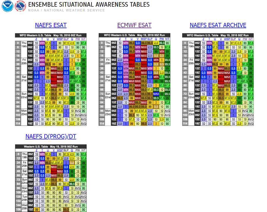
right entrance region of the upper jet. Moisture-wise, IVT
anomalies start to max out (for this time of year) in southern
Arizona and vicinity Sunday per the NAEFS Ensemble Situational
Awareness Tables, as strong and deep level Pacific moisture takes
aim at the region. Widespread moisture and cloud cover may limit
instability a bit, but at least a modest level of instability is
forecast to develop, given the strong troughing aloft should
steepen lapse rates. Soil moisture remains rather wet in most areas
due to heavy rain over the past days and weeks, increasing the
flooding threat hydrologically. All this, plus potential terrain
enhancements to rainfall, yields what is considered a higher-end
Slight Risk across the Southwest on Sunday. Moderate Risk level
impacts are possible and this potential will continue to be
monitored in future forecasts. A broader Marginal Risk expands west
through southern California and east across much of New Mexico.
The deep upper trough is forecast to track east across the
Intermountain West on Sunday night and Monday, with the southern
stream shortwave enhancing flow as it tracks northeast through the
eastern side of the broader trough. A strong southerly low level
jet will set up across the Plains Sunday night (tail end of Day 4)
and Monday ahead of a cold front anchored by a strengthening
surface low. Some instability will be pulled all the way north
across the Plains/Mississippi Valley toward the Upper Midwest,
allowing for some heavy rainfall rates. Will show a broad Marginal
Risk for this convective activity as a starting point for the Day 5
outlook. Thunderstorms look to have lower rain rates farther north
where there could be slower movement of convection, while higher
rates are possible farther south but could be more progressively
moving. Additionally, antecedent conditions are drier east of the
south-central High Plains for uncertainty in the impacts of heavy
rain. Do expect there could be a corridor of heavy rainfall that
could overcome drier soil conditions for flooding potential, for a
potential embedded Slight Risk in future issuances, but the
positioning is uncertain at this point.
...Florida...
Shortwave energy spilling into Florida on Sunday and Monday could
promote increased convective coverage. PWs should be 1.5-2 standard
deviations above average while global models show MUCAPE reaching
around 1500 J/kg at times. While much/all of Florida could see
scattered thunderstorms with locally heavy rain, will show Marginal
Risks for the east coast in particular, because of easterly low
level flow for increased convergence, and the urban centers that
are more sensitive to heavy rain. Sunday looks to be the primary
day for a flash flooding threat, but the AI models in particular
maintain some higher rain totals into Monday, so kept the Marginal
going through Day 5 as well.
Tate