
Welcome to the Washington Water Science Center
Washington Water Science Center
The USGS Washington Water Science Center provides water resource information. You’ll find information about Washington’s rivers and streams, as well as groundwater, water quality, and cutting-edge water research. We welcome you to explore our data and scientific research.
Current Washington Water Conditions
Current Washington Water Conditions

Explore real-time Washington streamflow, groundwater, and water-quality conditions and access data with our new interactive map application.
View current water conditions
View current water conditions
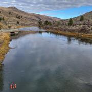
Uncrewed Aviation Systems Program
Uncrewed Aviation Systems Program

Data collection provided by uncrewed aviation systems (UAS) enhances the Washington Water Science Center’s (WAWSC) ability to monitor dynamic environmental systems, respond to natural hazards, analyze the impacts of climate change, and assess landscape change.
News
Sediment contaminants in Puget Sound: Implications for ecosystem health and remediation
Sediment contaminants in Puget Sound: Implications for ecosystem health and remediation
Washington Waters Newsletter - Spring 2025
Washington Waters Newsletter - Spring 2025
New data products now available in StreamStats
New data products now available in StreamStats
Publications
Urban heterogeneity drives dissolved organic matter sources, transport, and transformation from local to macro scales Urban heterogeneity drives dissolved organic matter sources, transport, and transformation from local to macro scales
Urbanization reshapes dissolved organic matter (DOM) sources, transport, and transformations through changes in vegetation, hydrology, and management of waste and water. Yet the impacts of urbanization on DOM are variable within and among cities. Predicting heterogeneous responses to urbanization is challenged by diverse human activities and underlying biophysical variation along stream...
Refining PAH and PCB bioavailability predictions in industrial sediments using source-fingerprinting, particle size, and bulk carbon, Puget Sound, Washington Refining PAH and PCB bioavailability predictions in industrial sediments using source-fingerprinting, particle size, and bulk carbon, Puget Sound, Washington
Nearshore marine sediments in a Puget Sound, Washington industrial embayment had elevated levels of PAHs, PCBs and DDTs. Chemical fingerprints implicated nearshore sources including creosote, industrial oil and tar waste, and a landfill. Elevated concentrations were confined to an approximate 300-m shoreline buffer in the industrial waterfront, suggesting high site fidelity and limited...
Relationships between water quality, stream metabolism, and water stargrass growth in the lower Yakima River, 2018 to 2020 Relationships between water quality, stream metabolism, and water stargrass growth in the lower Yakima River, 2018 to 2020
Since the early 2000s, water clarity on the lower Yakima River has improved. Changes in best management practices combined with a total maximum daily load for suspended sediment led to these improved conditions. As water clarity improved, so did conditions for aquatic plants; the clearer the water, the better the light penetration, and dramatic increases in plant biomass were observed...
Science

Carbon in Urban River Biogeochemistry Project
The Issue: In aquatic ecosystems, dissolved organic carbon represents the largest flux of carbon in streams and it is a primary energy source in aquatic food webs. There is limited understanding of how human activities related to urban development influence the timing and scale of carbon cycling in aquatic ecosystems. How USGS will help: The USGS is working with university partners to assess how...
Transboundary Water Quality Monitoring in Washington State
The USGS is monitoring the water quality of rivers that cross the U.S.-Canadian border. In Washington State, our focus is on the Upper Skagit and Similkameen watersheds. Intensive monitoring began in 2019, and the data we collect helps us understand current conditions and detect long-term changes in water quality.

Assessment of groundwater-surface water exchange to support Scatter Creek, Washington baseflow
Scatter Creek, a tributary to the Chehalis River, WA, experiences summer conditions that threaten native fish populations. Each year, parts of Scatter Creek go dry. Dry stretches of stream disconnect the habitat, so that fish can’t move upstream and downstream. Some of the water flowing through streams may seep into the ground and enter aquifers, meaning that the water is lost from the stream. The...