
Sediment contaminants in Puget Sound: Implications for ecosystem health and remediation
Seasonal erosion and accretion in a San Francisco Bay marsh
New seafloor mapping offshore Kodiak Island, Alaska, reveals extensive submarine landslides
Land-based nutrient flux to a fringing reef: insights from Ofu Island, American Samoa
Frequency and Intensity of Storm Surges Underestimated Nationally, Study Finds
USGS Coastal Storm Projection Data Inform Department of Defense Infrastructure Risk Assessments
Long-term Satellite Data Reveal How Climate Shapes West Coast Shorelines
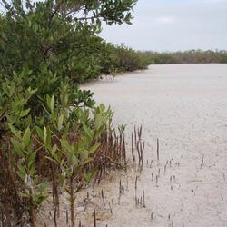
Ecological Thresholds, Abiotic Stress, and Climate Change: A Conceptual Framework
Nature-based "Horizontal Levees" Reduce Flood Risk in San Francisco Bay
A 700-year rupture sequence of great eastern Aleutian earthquakes from tsunami evidence and modeling
The Threat of Coastal Flooding from Cascadia Earthquake-Driven Land Subsidence
Pacific Coastal and Marine Science Center
PCMSC is one of three centers serving the mission of the USGS Coastal and Marine Hazards and Resources Program—the primary Federal marine geology and physical science research program responsible for the Nation’s entire coastal and marine landscape.
What We Do: Coastal and Marine Science at USGS Santa Cruz
What We Do: Coastal and Marine Science at USGS Santa Cruz

Get an overview of the coastal and marine research conducted by the USGS in Santa Cruz, California in our downloadable booklet.
Research Projects
Research Projects

Read about our science projects, find out where we are working, and discover the reasons why our research matters.
News
Modeling Flood-Mitigation Strategies in San Francisco Bay
Modeling Flood-Mitigation Strategies in San Francisco Bay
Meet the Autonomous MAPping CATaraft, or Autonomous MAPCAT
Meet the Autonomous MAPping CATaraft, or Autonomous MAPCAT
Sediment contaminants in Puget Sound: Implications for ecosystem health and remediation
Sediment contaminants in Puget Sound: Implications for ecosystem health and remediation
Publications
Bathymetric and acoustic-backscatter mapping of Lake Sammamish, Washington, during USGS field activity 2021-656-FA Bathymetric and acoustic-backscatter mapping of Lake Sammamish, Washington, during USGS field activity 2021-656-FA
In 2021, scientists from the U.S. Geological Survey (USGS) acquired bathymetric and acoustic-backscatter data within Lake Sammamish, Washington. Mapping was completed to find evidence of past earthquakes such as underwater landslides and is part of a larger USGS project to understand the overall geologic hazards history of the Cascadia Margin region. The survey was conducted using the...
Mineralization processes at Escanaba Trough Mineralization processes at Escanaba Trough
Escanaba Trough off northern California is the southernmost and only sediment covered segment of the Gorda Ridge. Hydrothermal mineralization was first discovered in Escanaba Trough in 1985, and subsequent investigations included the delineation of the NESCA (northern Escanaba) and SESCA (southern Escanaba) sections of Escanaba Trough, as well as drilling by Ocean Drilling Program (ODP)...
An exploration of the relative influence of physical models for Omori’s law An exploration of the relative influence of physical models for Omori’s law
Omori’s law states that the rate of aftershocks decays as a function of inverse time. There are multiple physical explanations that we reduce into a nonlinear mixed effects relation of three terms: (1) a Rate/State expression that can account for static/dynamic and viscoelastic triggering caused directly by the mainshock, (2) a fluid diffusion triggering term, and (3) a randomized...
Science

USGS research on coastal and nearshore ecosystems informs wildlife and fisheries management
Coastal ecosystems are where the land and sea meet. USGS coastal science plays a critical role in supporting effective, science-based management of coastal ecosystems. USGS helps decision-makers navigate complex ecosystem challenges.
By
Ecosystems Mission Area, Cooperative Research Units, Eastern Ecological Science Center, Forest and Rangeland Ecosystem Science Center, Lower Mississippi-Gulf Water Science Center, Pacific Coastal and Marine Science Center, Western Fisheries Research Center, Western Geographic Science Center, Wetland and Aquatic Research Center

Seafloor Benthic Mapping and Characterization: Enhancing our Understanding of Aleutian Islands’ Hazards, Potential Seabed Minerals and Deep Corals
A USGS-led expedition in the Aleutian Arc off Alaska will provide critical information on energy resources, underwater earthquakes and other hazards, seafloor habitats, and biological resources, including key fisheries, as well as potential seabed minerals.
By
Ecosystems Mission Area, Natural Hazards Mission Area, Coastal and Marine Hazards and Resources Program, Land Management Research Program, Species Management Research Program, Eastern Ecological Science Center, Pacific Coastal and Marine Science Center, St. Petersburg Coastal and Marine Science Center, Wetland and Aquatic Research Center , Woods Hole Coastal and Marine Science Center, Hawaiian Volcano Observatory, Deep Sea Exploration, Mapping and Characterization
Coastal Wetland Vulnerability to Climate Change and Sea-Level Rise: Understanding Ecological Thresholds and Ecosystem Transformations
Eighteen USGS coastal scientists from all four coasts of the conterminous United States are working together to advance the understanding of climate change and sea-level rise impacts to coastal wetlands.
By
California Water Science Center, Chesapeake Bay Activities, Eastern Ecological Science Center, Florence Bascom Geoscience Center, Great Lakes Science Center, Pacific Coastal and Marine Science Center, St. Petersburg Coastal and Marine Science Center, Western Ecological Research Center (WERC), Western Geographic Science Center, Wetland and Aquatic Research Center , Woods Hole Coastal and Marine Science Center