Log In


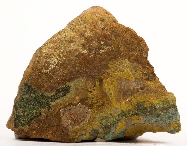
Delta Mine (Hidden Splendor), San Rafael Swell Mining District, Emery County, Utah, USAi
| Regional Level Types | |
|---|---|
| Delta Mine (Hidden Splendor) | Mine |
| San Rafael Swell Mining District | Mining District |
| Emery County | County |
| Utah | State |
| USA | Country |
This page is currently not sponsored. Click here to sponsor this page.
Latitude & Longitude (WGS84):
38° 33' 55'' North , 110° 56' 56'' West
Latitude & Longitude (decimal):
Type:
Köppen climate type:
Nearest Settlements:
| Place | Population | Distance |
|---|---|---|
| Hanksville | 212 (2017) | 29.6km |
| Emery | 272 (2017) | 47.5km |
| Torrey | 184 (2017) | 50.5km |
Other/historical names associated with this locality:
Delta-Hidden Splendor; Delta Uranium Mine; Pick's Mine
A former U-V-Cu-Pb-Zn occurrence/mine located in the SE¼SW¼NW¼ sec. 9, T26S, R9E, SLM, on Bureau of Land Management administered land. Discovered in 1952 by Mr. Vernon J. Pick. First produced in 1952. Owned by Central Oil and Minerals, Utah (1977). Operated by Hunt Mining (1977). USGS MRDS stated accuracy for this locality is 10 meters.
Mineralization is an U-V deposit hosted in Late Triassic mudstone and sandstone of the Chinle Formation-Monitor Butte Member. The ore body is a replacement tabular-blanket body that strikes N68E and dips 9SE at a thickness of 6.1 meters, width of 15.24 meters and a length of 45.72 meters and a depth-to-top of 45.72 meters and a depth-to-bottom of 213.36 meters. Primary ore control was lithology. Conflicting data regarding the ore body statistics are provided in MRDS file #10227306: strike = N75E, dip = 6S, thickness = 2.4 meters, width = 122 meters, length = 152 meters, depth-to-top = 0 meters, and, the area of coverage = 0.2 HA. Wallrock alteration is slight (carbonitization) and bleaching in the sandstone and mudstone. Local rocks include Triassic (1) sedimentary rocks in Salt southeastern Utah.
Regional geologic structures include the San Rafael Swell. Local structures include N-S-trending fractures. Relevant tectonic structures include a stable platform.
Workings include unspecified underground openings with a length of 1,524 meters and an overall depth of 213.36 meters.
Select Mineral List Type
Standard Detailed Gallery Strunz Chemical ElementsCommodity List
This is a list of exploitable or exploited mineral commodities recorded at this locality.Mineral List
12 valid minerals.
Rock Types Recorded
Note: data is currently VERY limited. Please bear with us while we work towards adding this information!
Select Rock List Type
Alphabetical List Tree DiagramDetailed Mineral List:
| ⓘ Boltwoodite Formula: (K,Na)(UO2)(SiO3OH) · 1.5H2O |
| ⓘ Carnotite Formula: K2(UO2)2(VO4)2 · 3H2O |
| ⓘ Goethite Formula: Fe3+O(OH) |
| ⓘ Gypsum Formula: CaSO4 · 2H2O |
| ⓘ Hematite Formula: Fe2O3 |
| ⓘ Malachite Formula: Cu2(CO3)(OH)2 |
| ⓘ Pyrite Formula: FeS2 |
| ⓘ Quartz Formula: SiO2 |
| ⓘ Sphalerite Formula: ZnS |
| ⓘ Torbernite Formula: Cu(UO2)2(PO4)2 · 12H2O |
| ⓘ Uraninite Formula: UO2 |
| ⓘ Zippeite Formula: K3(UO2)4(SO4)2O3(OH) · 3H2O |
Gallery:
List of minerals arranged by Strunz 10th Edition classification
| Group 2 - Sulphides and Sulfosalts | |||
|---|---|---|---|
| ⓘ | Sphalerite | 2.CB.05a | ZnS |
| ⓘ | Pyrite | 2.EB.05a | FeS2 |
| Group 4 - Oxides and Hydroxides | |||
| ⓘ | Goethite | 4.00. | Fe3+O(OH) |
| ⓘ | Hematite | 4.CB.05 | Fe2O3 |
| ⓘ | Quartz | 4.DA.05 | SiO2 |
| ⓘ | Uraninite | 4.DL.05 | UO2 |
| ⓘ | Carnotite | 4.HB.05 | K2(UO2)2(VO4)2 · 3H2O |
| Group 5 - Nitrates and Carbonates | |||
| ⓘ | Malachite | 5.BA.10 | Cu2(CO3)(OH)2 |
| Group 7 - Sulphates, Chromates, Molybdates and Tungstates | |||
| ⓘ | Gypsum | 7.CD.40 | CaSO4 · 2H2O |
| ⓘ | Zippeite | 7.EC.05 | K3(UO2)4(SO4)2O3(OH) · 3H2O |
| Group 8 - Phosphates, Arsenates and Vanadates | |||
| ⓘ | Torbernite | 8.EB.05 | Cu(UO2)2(PO4)2 · 12H2O |
| Group 9 - Silicates | |||
| ⓘ | Boltwoodite | 9.AK.15 | (K,Na)(UO2)(SiO3OH) · 1.5H2O |
List of minerals for each chemical element
| H | Hydrogen | |
|---|---|---|
| H | ⓘ Boltwoodite | (K,Na)(UO2)(SiO3OH) · 1.5H2O |
| H | ⓘ Carnotite | K2(UO2)2(VO4)2 · 3H2O |
| H | ⓘ Goethite | Fe3+O(OH) |
| H | ⓘ Gypsum | CaSO4 · 2H2O |
| H | ⓘ Malachite | Cu2(CO3)(OH)2 |
| H | ⓘ Torbernite | Cu(UO2)2(PO4)2 · 12H2O |
| H | ⓘ Zippeite | K3(UO2)4(SO4)2O3(OH) · 3H2O |
| C | Carbon | |
| C | ⓘ Malachite | Cu2(CO3)(OH)2 |
| O | Oxygen | |
| O | ⓘ Boltwoodite | (K,Na)(UO2)(SiO3OH) · 1.5H2O |
| O | ⓘ Carnotite | K2(UO2)2(VO4)2 · 3H2O |
| O | ⓘ Goethite | Fe3+O(OH) |
| O | ⓘ Gypsum | CaSO4 · 2H2O |
| O | ⓘ Hematite | Fe2O3 |
| O | ⓘ Malachite | Cu2(CO3)(OH)2 |
| O | ⓘ Quartz | SiO2 |
| O | ⓘ Torbernite | Cu(UO2)2(PO4)2 · 12H2O |
| O | ⓘ Uraninite | UO2 |
| O | ⓘ Zippeite | K3(UO2)4(SO4)2O3(OH) · 3H2O |
| Na | Sodium | |
| Na | ⓘ Boltwoodite | (K,Na)(UO2)(SiO3OH) · 1.5H2O |
| Si | Silicon | |
| Si | ⓘ Boltwoodite | (K,Na)(UO2)(SiO3OH) · 1.5H2O |
| Si | ⓘ Quartz | SiO2 |
| P | Phosphorus | |
| P | ⓘ Torbernite | Cu(UO2)2(PO4)2 · 12H2O |
| S | Sulfur | |
| S | ⓘ Gypsum | CaSO4 · 2H2O |
| S | ⓘ Pyrite | FeS2 |
| S | ⓘ Sphalerite | ZnS |
| S | ⓘ Zippeite | K3(UO2)4(SO4)2O3(OH) · 3H2O |
| K | Potassium | |
| K | ⓘ Boltwoodite | (K,Na)(UO2)(SiO3OH) · 1.5H2O |
| K | ⓘ Carnotite | K2(UO2)2(VO4)2 · 3H2O |
| K | ⓘ Zippeite | K3(UO2)4(SO4)2O3(OH) · 3H2O |
| Ca | Calcium | |
| Ca | ⓘ Gypsum | CaSO4 · 2H2O |
| V | Vanadium | |
| V | ⓘ Carnotite | K2(UO2)2(VO4)2 · 3H2O |
| Fe | Iron | |
| Fe | ⓘ Goethite | Fe3+O(OH) |
| Fe | ⓘ Hematite | Fe2O3 |
| Fe | ⓘ Pyrite | FeS2 |
| Cu | Copper | |
| Cu | ⓘ Malachite | Cu2(CO3)(OH)2 |
| Cu | ⓘ Torbernite | Cu(UO2)2(PO4)2 · 12H2O |
| Zn | Zinc | |
| Zn | ⓘ Sphalerite | ZnS |
| U | Uranium | |
| U | ⓘ Boltwoodite | (K,Na)(UO2)(SiO3OH) · 1.5H2O |
| U | ⓘ Carnotite | K2(UO2)2(VO4)2 · 3H2O |
| U | ⓘ Torbernite | Cu(UO2)2(PO4)2 · 12H2O |
| U | ⓘ Uraninite | UO2 |
| U | ⓘ Zippeite | K3(UO2)4(SO4)2O3(OH) · 3H2O |
Other Databases
| Link to USGS MRDS: | 10089343 |
|---|
Other Regions, Features and Areas containing this locality
North AmericaContinent
North America PlateTectonic Plate
- Chugar Group Area BasinBasin
- Colorado PlateauShield
- Mojave DomainDomain
USA
- Colorado PlateauPlateau
This page contains all mineral locality references listed on mindat.org. This does not claim to be a complete list. If you know of more minerals from this site, please register so you can add to our database. This locality information is for reference purposes only. You should never attempt to
visit any sites listed in mindat.org without first ensuring that you have the permission of the land and/or mineral rights holders
for access and that you are aware of all safety precautions necessary.
References
Page, Lincoln R., Stocking, Hobart E., Smith, Harriet B. (1956) Contributions to the geology of uranium and thorium by the United States Geological Survey and Atomic Energy Commission for the United Nations International Conference on Peaceful Uses of Atomic Energy, Geneva, Switzerland, 1955. Professional Paper 300. US Geological Survey doi:10.3133/pp300 pp.275-278
Delta Mine, San Rafael Swell Mining District, Emery County, Utah, USA